


Arnold, CA…It will be warming into the weekend and the National Weather Service has issued a Fire Weather Watch. The Detailed forecasts for the West Slope Northern Sierra Nevada, Mother Lode & Fire Weather Watch are below…
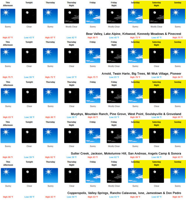
Today Haze in the morning. Sunny. Highs 62 to 77 higher elevations…74 to 84 lower elevations. Prevailing southeast winds up to 10 mph shifting to the southwest in the afternoon.
Tonight Clear. Lows 42 to 57 higher elevations…51 to 65 lower elevations. Prevailing southwest winds up to 10 mph shifting to the southeast after midnight. Gusts up to 25 mph.
Thursday Sunny. Highs 61 to 76 higher elevations…72 to 82 lower elevations. Prevailing southeast winds up to 10 mph shifting to the southwest in the afternoon.
Thursday Night Clear. Lows 41 to 56 higher elevations…50 to 64 lower elevations. Prevailing southwest winds up to 10 mph shifting to the southeast after midnight. Gusts up to 25 mph.
Friday Mostly sunny. Highs 64 to 79 higher elevations…73 to 83 lower elevations. Prevailing southeast winds up to 10 mph shifting to the west in the afternoon.
Friday Night Mostly clear. Lows 47 to 62.
Saturday Sunny, warmer. Highs 71 to 86.
Saturday Night Through Tuesday Clear. Lows 51 to 66. Highs 74 to 89.
Detailed forecast for Motherlode
Today Haze in the morning. Sunny. Highs 78 to 88. Prevailing east winds up to 10 mph shifting to the southwest in the afternoon.
Tonight Clear. Lows 54 to 64. Prevailing southwest winds up to 10 mph shifting to the east after midnight.
Thursday Sunny. Highs 77 to 85. Light winds becoming west up to 10 mph in the afternoon.
Thursday Night Clear. Lows 52 to 64. Prevailing west winds up to 10 mph shifting to the east after midnight.
Friday Sunny. Highs 78 to 86. Light winds becoming west up to 10 mph in the afternoon.
Friday Night Clear. Lows 56 to 66.
Saturday Sunny, warmer. Highs 83 to 93.
Saturday Night Through Tuesday Clear. Lows 60 to 74. Highs 84 to 99.
Fire Weather Watch
URGENT – FIRE WEATHER MESSAGE
National Weather Service Sacramento CA
147 AM PDT Wed Sep 23 2020
…Critical Fire Weather Conditions Possible Saturday Morning
through Monday Morning…
.Gusty northerly and easterly winds are possible this weekend
into late Monday morning. Poor humidity recovery is expected
during this time frame as well, with daytime humidities in the
teens. Combination of wind, low humidity and hot conditions could
result in critical fire weather conditions which may impact
ongoing wildfires. Extreme caution should be taken to prevent new
fire starts.
CAZ213-215>221-263-266>269-279-232300-
/O.CON.KSTO.FW.A.0006.200926T1800Z-200928T1500Z/
Eastern Portion of Shasta/Trinity NF-
Northern Sacramento Valley to Southern Tehama County Line Below
1000 Ft-
Central Sacramento Valley in Glenn, Colusa, Yuba, Northern
Sutter, and Butte County Below 1000 Ft-
Southern Sacramento Valley in Yolo-
Sacramento Far Western Placer, southern Sutter and Solano County
Below 1000 Ft-Carquinez Strait and Delta-
Northern San Joaquin Valley in San Joaquin and Stanislaus
Counties Below 1000 ft-
Southern Motherlode From 1000 to 3000 Ft. Includes portions of
Calaveras-Tuolumne Unit-Stanislaus NF West of the Sierra Crest-
Southeast Edge Shasta-Trinity NF and Western Portions of Tehama-
Glenn Unit-
Northern Sierra Foothills from 1000 to 3000 Ft. Includes portions
of Shasta-Trinity and Butte Units-
Northern Motherlode From 1000 to 3000 Ft. Includes portions of
Nevada-Yuba-Placer-Amador and ElDorado Units-
Northern Sierra Including Lassen NP and Plumas and Lassen NF/S
West of the Sierra Crest (West of Evans Peak-Grizzly Peak-
Beckworth Peak)-
Northern Sierra Including the Tahoe and ElDorado NF/S West of the
Sierra Crest-Eastern Mendocino NF-
147 AM PDT Wed Sep 23 2020
…FIRE WEATHER WATCH REMAINS IN EFFECT FROM SATURDAY MORNING
THROUGH MONDAY MORNING FOR GUSTY WIND AND LOW HUMIDITY FOR FIRE
WEATHER ZONES 213, 215, 216, 217, 218, 219, 220, 221, 263, 266,
267, 268, 269, AND 279…
* AFFECTED AREA…Portions of interior northern California
including the west side of the Sacramento Valley, the Coastal
Range, the Sierra Nevada foothills and the Delta.
* WIND…North to east winds 10 to 20 mph with gusts up to 30 mph.
Stronger gusts may be possible through favored gaps and
canyons. Strongest winds expected late Saturday night,
especially on the west side of the Sacramento Valley and
adjacent terrain.
* HUMIDITY…Minimum daytime humidity of 10 to 20. Maximum
overnight humidity between 20 and 40 percent. Higher humidity
recovery expected in the Central Valley and Delta areas.
* IMPACTS…Numerous wildfires are already occurring. Extreme
fire safety precautions should be exercised to prevent any
additional fires. Outdoor burning should be avoided.
PRECAUTIONARY/PREPAREDNESS ACTIONS…
A Fire Weather Watch means that critical fire weather conditions
are forecast to occur. Listen for later forecasts and possible
Red Flag Warnings.
$$
Warming Weather Later This Week Leading to Fire Weather Watch this Weekend added by admin on
View all posts by admin →