


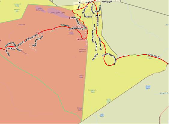
Grizzly Flats, CA…Update to Evacuation Orders, Warnings, and Road Closures is Effective Immediately for El Dorado and Alpine Counties Road Closures: The Highway 50 closure has been extended East to Meyers (Highway 50 and Highway 89 junction). Evacuation Routes: Residents evacuating the area should use Highway 50 East. Evacuation Order: El Dorado County From Twin Bridges east to Echo Summit , From Highway 50 South to Amador/Alpine County line , From Highway 50 North to Flag Pole Peak.
Evacuation Warnings:
El Dorado County
• Christmas Valley from Highway 89 West to Echo Summit
• Highway 89 due West to Watershed Ridge and South to the Amador/El Dorado County line.
Alpine County
• Highway 89 South from Luther Pass Road to the Pickets Junction (Highway 88).
• West on Highway 88 to Kirkwood.
Evacuation Shelter:
Nevada
• A Red Cross Shelter is open for those evacuating from the area at the Douglas County Community Center, 1329 Waterloo Lane, Gardnerville, NV.
NOTES:
Please go to: www.tinyurl.com/EDSOEVAC for an online evacuation map.
All previous evacuation orders and warnings remain in effect
A mandatory evacuation order is defined as an immediate threat to life. This is a lawful order to leave now. The area is lawfully closed to public access.
An evacuation warning is defined as a potential threat to life and/or property. Those who require additional time to evacuate, and those with pets and livestock should leave now.
Safety Message:
The public is reminded to stay vigilant on current fire conditions. Please continue to adhere to road closures and any evacuation orders and warnings. A reminder to drive slowly and yield to emergency personnel in the area. There will be smoke in the respective areas as firefighters continue firefighting
operations. If at any time you feel unsafe, please call 911.
Caldor Fire Evacuations Spread to Alpine County & Closer to Tahoe, Hwy 50 Closure Moved to Meyers added by admin on
View all posts by admin →