


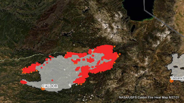
Grizzly Flats, CA…The Northeast areas of the fire remained the most active overnight due to poor humidity recovery. The fire experienced short-range spotting that aligned with nighttime flow patterns producing several new ignitions within the control lines. Additionally, passive crown fires were common in the Northeastern, and Eastern areas of the incident. Critical fuel conditions, steep and rugged terrain still present a challenge for firefighters. Crews continued with the firing operation to improve and strengthen control lines.
To better provide public and firefighter safety due to extreme fire conditions throughout Northern California, and strained firefighter resources throughout the Country, the USDA Forest Service Pacific Southwest Region is announcing a temporary closure of nine National Forests. This closure will be effective on August 22, 2021, at 11:59 p.m. through September 6, 2021, at 11:59 p.m. The closure order can be found at https://tinyurl.com/USFSClosure.
Subscribe to email alerts: https://lp.constantcontactpages.com/su/bqzL6B6/caldorfire
AMADOR COUNTY – WARNINGS:
Shenandoah Road at the Amador County line west through the River Pines community, continuing west on Shenandoah Road to Ostrom Road.
South on Ostrom Road to Jibboom Street, West on Jibboom Street to Fiddletown Road.
East on Fiddletown Road to Hale Road. South on Hale Road to Shake Ridge Road.
East on Shake Ridge Road to Charleston Road.
South on Charleston Road to the intersection of Charleston Road and Rams Horn Grade.
Due east to Highway 88 at Tiger Creek Road.
Tiger Creek Road east to Salt Springs Reservoir Road.
East on Salt Springs Reservoir Road to the east end of the Salt Springs Reservoir.
Due north from the east end of Salt Springs Reservoir to Highway 88.
South of the El Dorado-Amador County line with a western border of Highway 88 due south to the east end of Salt Springs Reservoir.
Southern border of the Calaveras County line.
Eastern border of the Alpine County line
EL DORADO COUNTY – ORDERS:
Grizzly Flat: The areas on Grizzly Flats Road east of Kendra Way into Grizzly
Flats Proper. The areas of Diamond Railroad Grade, Old School House, Sweeney Road, Caldor Road, and Steely Ridge.
Grizzly Flats Road east of four corners in somerset into Grizzly Flats Proper.
The areas of Myers Lane, Varmet Ridge Road, Rodwell Canyon Road, Snowbird Lane, and Mehwald Lane.
East of Sly Park Road between Highway 50 and Mormon Emigrant Trail to Ice House Road. This includes the communities of Pacific House and Fresh Pond.
North of Highway 50, east of Forebay Road to Ice House Road.
Intersection of Perry Creek and Hawk Haven, the East side of Fairplay Road from Perry Creek South to Cedarville Road. This includes Slug Gulch, Omo Ranch, and all roads off of Slug Gulch and Omo Ranch.
All roads off of Omo Ranch from Cedarville Road to Hwy 88.
The area between Highway 88 and Mormon Emigrant Trail
South of Highway 50 from Snows Road to Ice House Road.
Between Highway 50 and Slab Creek from Snows Road to Ice House Road.
South of Highway 50 from Ice House Road to Silver Fork Road. This includes the community of Kyburz.
North of Highway 50 from Ice House Road to Silver Fork Road to include Ice House Reservoir, Union Valley Reservoir, and Loon Lake.
Silver Fork Road in Kyburz east to Twin Bridges.
North and south in a line extending from Twin Bridges to the Placer County line and south to the Amador County line.
Areas south of Farnham Ridge Road and east of Bridgeport School Road to the Amador County line.
From Twin Bridges east to Echo Summit.
From Highway 50 South to Amador/ Alpine County Line.
From Highway 50 North to Flag Pole Peak.
EL DORADO COUNTY EVACUATION WARNINGS:
North of Slab Creek to Wentworth Springs Road between Sand Mountain and Loon Lake.
Mosquito Road from the bridge North to include the Community of Swansboro.
North of Highway 50 to Slab Creek between Smith Flat and Snows Road.
South of Highway 50 to Pleasant Valley between Smith Flat and Snows Road, and North of Pleasant Valley between Holm and Newtown.
South of Pleasant Valley between Bucks Bar Road and Newtown Road, East of Bucks Bar Road to Mt Aukum Road.
Southwest of Bucks Bar Road to Ladies Valley Road including the community of Outingdale, Ant Hill Road, Perry Creek Road and Sand Ridge between Ladies Valley Road and Bucks Bar Road.
East of Mt Aukum Road (E16) from Bucks Bar Road to Omo Ranch Road. North of Omo Ranch Road to the intersection of Omo Ranch Road and Fairplay Road.
South of Omo Ranch to the El Dorado County Line between Mt Aukum Road (E16) and Fairplay Road to include Coyoteville Road, Cedar Creek and all tributary roads.
From the evacuation order line in Twin Bridges east to the Echo Summit and from Highway 50 south to the Amador and Alpine County lines and north to the Placer County line.
Dry Lakes Section: This section is north of Wentworth Springs Road up to the Placer County line and the remaining section of El Dorado County south of Placer County to Loon Lake.
Christmas Valley from Highway 89 to Echo Summit.
Highway 89 due West to Watershed Ridge and South to the Amador/ El Dorado County line.
ALPINE COUNTY – WARNINGS:
Highway 89 South from Luther Pass Road to the Pickets Junction (Highway
88)
West on Highway 88 to Kirkwood.
EL DORADO COUNTY – ROAD CLOSURES
Highway 50 will be closed in both directions from the Sly Park Road exit to Meyers (Highway 50 and Highway 89 junction).
EVACUATION CENTERS:
EL DORADO COUNTY
Shelter
Green Valley Community Church
3500 Missouri Flat Road
Placerville, CA
Shelter
Cameron Park CSD
2502 Country Club Drive
Cameron Park, CA
Shelter
Rolling Hills Church
800 White Rock Road
El Dorado Hills, CA
AMADOR COUNTY
Temporary Evacuation Point FULL
Amador County Fairgrounds
18621 Sherwood Street
Plymouth, CA
Shelter FULL
Evelynn Bishop Hall
701 Hwy 124
Ione, CA
855-755-7711
NEVADA
Shelter
Douglas County Community Center
1329 Waterloo Lane
Gardnerville, NV
Animal Evacuation Centers:
El Dorado County Animal Services (small animals)
6435 Capitol Ave.
Diamond Springs, CA
For animal evacuation questions or assistance call (530) 621-5795
Saureel Vineyards (large animals)- FULL
1140 Cold Springs Road
Placerville, CA
(530) 621-5795
Amador County Fairgrounds (large animal)- for Amador County residents only
18621 Sherwood Street
Plymouth, CA (209) 257-9444
Damages and Losses
Confirmed Damage to Property, Injuries, and Fatalities
37 Structures Damaged
Residential, Commercial and Other
650 Structures Destroyed
Residential, Commercial and Other
Contact Information
Information Line
530-303-2455
Media Contact
530-497-0315
Sign up for email updates
https://lp.constantcontactpages.com/su/bqzL6B6/caldorfire
Agency Information
El Dorado National Forest
100 Forni Road Placerville California 95667
530-303-2455
https://inciweb.nwcg.gov/incident/7801/
El Dorado County Sheriff’s Office
(530) 621-5655
https://www.edcgov.us/Government/sheriff/
Pioneer Fire District
(530) 620-4444
http://pioneerfire.org/
Cooperating Agencies: El Dorado County Sheriff’s Office, Sierra Pacific Industries, Pioneer FD, PG&E, CHP, El Dorado Irrigation District, El Dorado County, Grizzly Flats Community Service District, SMUD, Amador County Sheriff’s Office, AT&T, Georgetown FD, CALTRANS, Indian Diggins School District, El Dorado County FD, Grizzly Flats Water District, Volcano Telephone, Placerville FD, El Dorado County DOT, Mosquito FD, Garden Valley FD, Cal OES Fire, El Dorado County EMSA, El Dorado County Office of Education, Marshall Medical Center, Shingle Springs Band of Miwok Indians FD, State Water Resources Control Board, KAMPS, El Dorado County Department of Agriculture, Barton Health, CAL EPA, Lake Valley Fire District, and Verizon
Resources Assigned
CAL FIRE owns and operates over 3,000 fire and emergency response and resource protection vehicles. In support of its ground forces, the CAL FIRE emergency response air program includes 23 Grumman S-2T 1,200 gallon airtankers, 12 UH-1H Super Huey helicopters, and 16 OV-10A airtactical. From 13 air attack and 10 helitack bases located statewide, aircraft can reach most fires within 20 minutes.
25 Helicopters
250 Engines
71 Dozers
63 Water Tenders
2,897 Personnel
82 Crews
Caldor Fire Now 143,951 Acres, 12% Contained, 2,897 Personnel, 650 Structures Destroyed as it Burns Towards Tahoe added by admin on
View all posts by admin →