


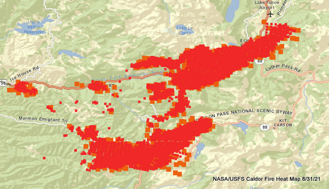
Grizzly Flats, CA…The top map is the NASA/USFS heat map. In the heat map you can tell it burned across Hwy 89 and is racing behind South Lake Tahoe on the ridge towards Heavenly Ski Resort. Yesterday Sierra at Tahoe today Heavenly & Kirkwood? Time will tell. On the southern leg the fire has crossed Hwy 88 and getting close to Kirkwood. It burned through the beautiful section of woods between Silver Lake and the Carson Spur area and is climbing over the hill to Kirkwood. That area has less vegetation and more rock which may slow it down a bit. All the images below are links to take you to the source documents. The following text is from the Caldor Incident Command.
Caldor Fire
Overview
Contacts
191,607 Acres
16%
Contained
Active
Active for 17 days
2 Counties
El Dorado and Amador
Last Updated 08/31/21 10:22 AM
Date Started 08/14/21 12:00 AM
Location Information East of Omo Ranch, South of the community of Grizzly Flats
Lat/Long [38.586, -120.537833]
Administrative Unit Unified Command: CAL FIRE Amador-El Dorado Unit and El Dorado National Forest
Cause Unknown
Reports Click here for prior status reports
Status Updates
Caldor Damage Inspection Map: View the Damage Inspection Map.
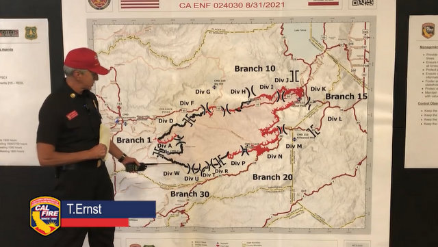
CURRENT SITUATION:
Overnight fire activity remained active throughout the northeastern and eastern areas of the fire due to poor humidity recovery. Crown fire runs and ember casting remained active covering distances of up to three quarters of a mile. Lower elevations of the fire saw strong down canyon winds that tested control lines in Divisions A and D. The current red flag warning remains in effect through 11:00 p.m. on 9/1/21.
To better provide public and firefighter safety due to extreme fire conditions throughout Northern California, and strained firefighter resources throughout the Country, the USDA Forest Service Pacific Southwest Region is announcing a temporary closure of nine National Forests. This closure will be effective on August 22, 2021, at 11:59 p.m. through September 6, 2021, at 11:59 p.m. The closure order can be found at https://tinyurl.com/USFSClosure.
Local Assistance Center:
Address: 6699 Campus Drive, Placerville, CA 95667. Located at Folsom Lake Community College, El Dorado Campus, Fitness Center Building.
Hours: Monday through Friday 10:00 a.m. to 5:00 p.m., Wednesdays 1:00 p.m. to 7:00 p.m.
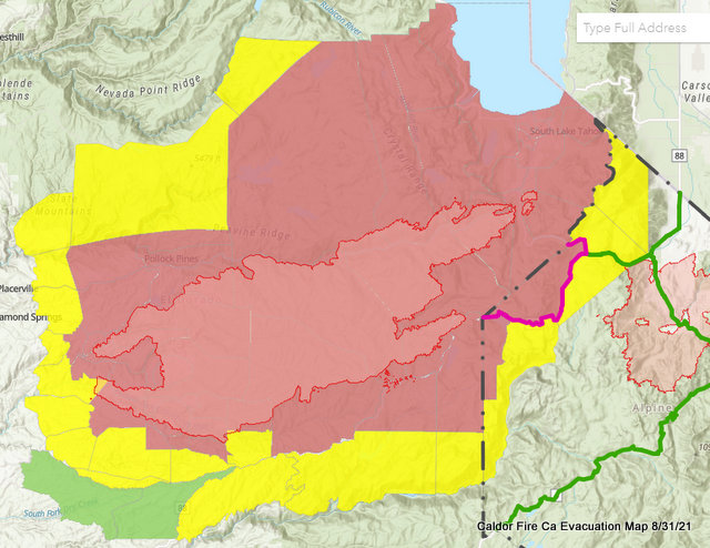
Active Evacuation Map: https://eldoradocounty.maps.arcgis.com/apps/webappviewer/index.html?id=c995bf3816964e948d7d831d3ba938ff
AMADOR COUNTY
Evacuation Order:
South of Highway 88 along the Amador/El Dorado County line from Dufrene Road, due east to the Amador/Alpine County line and from the Amador/Alpine County line north to Highway 88. This includes the area of Kirkwood Lake.
Evacuation Warning:
South of the Amador/El Dorado County line along Highway 88 from Dufrene Road west to Omo Ranch Road.
North of Tiger Creek Road east to Salt Springs Reservoir Road to the east end of the Salt Springs Reservoir.
West of the Amador/Alpine County line to Highway 88.
East of Highway 88 to the Amador/Alpine County line
Road Closures:
Highway 88 is closed between Peddlers Ridge and the Highway 88/89 interchange.
EL DORADO COUNTY
Evacuation Orders:
Grizzly Flat: The areas on Grizzly Flats Road east of Kendra Way into Grizzly
Flats Proper. The areas of Diamond Railroad Grade, Old School House, Sweeney Road, Caldor Road, and Steely Ridge.
Grizzly Flats Road east of four corners in Somerset into Grizzly Flats Proper.
The areas of Myers Lane, Varmet Ridge Road, Rodwell Canyon Road, Snowbird Lane, and Mehwald Lane.
East of Sly Park Road between Highway 50 and Mormon Emigrant Trail to Ice House Road. This includes the communities of Pacific House and Fresh Pond.
North of Highway 50, east of Forebay Road to Ice House Road.
Intersection of Perry Creek and Hawk Haven, the East side of Fairplay Road from Perry Creek South to Cedarville Road. This includes Slug Gulch, Omo Ranch, and all roads off of Slug Gulch.
All roads off of Omo Ranch from Cedarville Road to Hwy 88.
The area between Highway 88 and Mormon Emigrant Trail
South of Highway 50 from Snows Road to Ice House Road.
Between Highway 50 and Slab Creek from Snows Road to Ice House Road.
South of Highway 50 from Ice House Road to Silver Fork Road. This includes the community of Kyburz.
North of Highway 50 from Ice House Road to Silver Fork Road to include Ice House Reservoir, Union Valley Reservoir, and Loon Lake.
Silver Fork Road in Kyburz east to Twin Bridges.
North and south in a line extending from Twin Bridges to the Placer County line and south to the Amador County line.
From Twin Bridges east to Echo Summit.
From Highway 50 South to Amador/ Alpine County Line.
From Highway 50 North to Flag Pole Peak.
Pleasant Valley Road and all intersecting roads extending south from Newtown Road to the intersection of E-16 (Mt Aukum Road).
All roads accessed from E-16 (Mt Aukum Road) between Pleasant Valley Road and Bucks Bar Road.
This includes all roads and residences accessed from Moon-Shadow and Gopher Hole Road off Bucks Bar Road.
Christmas Valley from Highway 89 West to Echo Summit
Highway 89 due West to Watershed Ridge/Echo Summit and South to the Amador/El Dorado County line.
The area from Luther Pass Road, north along the El Dorado/Alpine County line to Armstrong Pass. West from Armstrong Pass to Upper Apache at Meyers. West on Upper Apache to Highway 50. West on Highway 50 to Highway 89. South on Highway 89 to the El Dorado/Alpine County line. This includes all homes on both sides of Highway 89.
The area from Upper Apache at Meyers, north along Highway 50, to Elks Club Drive. East on Elks Club Drive to Pioneer Trail, extending due south to Upper Apache at Meyers. (This includes all homes off of Oneidas, Mandan, Apache, Ottawa, and Player).
The area North on Highway 50 from Highway 89 to Saw Mill Road. West on Saw Mill Road to Angora Ridge, extending to the Echo Summit.
Desolation Wilderness from the watershed ridge to the CA ENF/CA TMU wilderness boundary. From the El Dorado/Placer county line to Echo Lakes.
The section from Emerald Bay north to the Placer county line in Tahoma, extending west to the border of Desolation Wilderness.
The area from Sawmill Road at Lake Tahoe Blvd. extending north to Pope Beach. Along the water’s edge to Eagle Point. From Eagle Point west, to Desolation Wilderness, across Emerald Bay.
This is the area North of Elks Club along Highway 50 and the West side of Pioneer Trail, also including the streets of Hekpa, excluding the residences west of the airport, this segment includes all residences accessed from Jicarilla, Washoan, and Glen Eagles. This also includes the Golden Bear neighborhood, and the neighborhoods of Cold Creek Trail, High Meadows, and Marshall Trail.
Northwest of the South Lake Tahoe Airport and west of the Highway 50 / Lake Tahoe Blvd and Highway 89 intersection to include the South Lake Tahoe High School, Tahoe Verde and the streets accessed from 5th through 15th street south of Highway 89.
The area East of Pioneer Trail to the Alpine County Line stopping South of Heavenly Ski Resort, excluding all residence off of Pioneer Trail.
All residences with the Tahoe Keys community and all residents accessed from the streets connEast of Highway 50/ Highway 89 at the at the Lake Tahoe Blvd and
Highway 89 Highway 50 intersection. This includes the area of Barton Hospital and the area of Winnemucca to the “Y”. Also north of Highway 50 west of Tahoe Keys Blvd following along the north side of Highway 89 through the end of town prior to Pope Beach.ected to Tahoe Keys Blvd, staying east of 3rd Street.
All residences off of Lakeview which is west of Highway 50 North of Blue Lakes Road and east of Tahoe Keys Neighborhood.
All residences on both sides of Highway 50 for the streets connected to O’Malley, Lodi, Silver Dollar and Rubicon Trail.
The residences between Al Tahoe on the east side of Johnson Blvd to include the streets of Treehaven and Fremont and extending to the east in to all residences west of Ski Run and east of Pioneer Trail.
Evacuation Warnings:
North of Slab Creek to Wentworth Springs Road between Sand Mountain and Loon Lake.
Mosquito Road from the bridge North to include the Community of Swansboro.
North of Highway 50 to Slab Creek between Smith Flat and Snows Road.
South of Highway 50 to Pleasant Valley between Smith Flat and Snows Road, and North of Pleasant Valley between Holm and Newtown.
South of Pleasant Valley between Bucks Bar Road and Newtown Road, East of Bucks Bar Road to Kingsbury Drive.
Southwest of Bucks Bar Road to Ladies Valley Road including the community of Outingdale, Ant Hill Road, Perry Creek Road, and Sand Ridge between Ladies Valley Road and Bucks Bar Road.
East of Mt Aukum Road (E16) from Bucks Bar Road to Omo Ranch Road. North of Omo Ranch Road to the intersection of Omo Ranch Road and Fairplay Road.
From the evacuation order line in Twin Bridges east to the Echo Summit and from Highway 50 south to the Amador and Alpine County lines and north to the Placer County line
Dry Lakes Section: This section is north of Wentworth Springs Road up to the Placer County line and the remaining section of El Dorado County south of Placer County to Loon Lake.
The area from Sawmill Road at Lake Tahoe Blvd. extending north to Pope Beach. Along the water’s edge to Eagle Point. From Eagle Point west to Desolation Wilderness, across Emerald Bay
The remaining area of the Lake Tahoe Basin. From the Alpine/El Dorado county line, north along the California/Nevada state line to Lake Tahoe. North along the waters edge to the El Dorado/Placer county line. West along the El Dorado/Placer county line to McKinney Lake
Road Closures:
Highway 50 is closed in both directions from the Sly Park Road exit to Meyers (Highway 50 and Highway 89 junction).
The Highway 50 closure has been extended East to Sawmill Road
Highway 50 at Sawmill
Pioneer Trail at Elks Club
Elks Club at Highway 50
Highway 89 at Highway 88 junction
Fallen Leaf at Tahoe Mountain
ALPINE COUNTY
Evacuation Order:
Highway 89 south from Luther Pass Road to Pickett’s Junction, (Highway 88) West on Highway 88 to Kirkwood. This includes Kirkwood resort and Caples Lake.
Evacuation Warning:
Highway 88 at Forestdale Road. West of Forestdale Road and south to the Pacific Crest Trail Crossing. West of the Pacific Crest Trail to the Summit City Canyon Trail. West of Summit City Canyon Trail and south to the El Dorado / Stanislaus National Forest Line. El Dorado / Stanislaus National Forest Line west to the Alpine and Amador County line.
South of Armstrong Summit to Woodfords to Forestdale Road, north of Highway 88 and Highway 89 to Armstrong Summit.
DOUGLAS COUNTY
Evacuation Warning:
Upper Kingsbury (South)
Upper Kingsbury (North)
Central Kingsbury
Lower Kingsbury
Round Hill region and roads including Lower Elks Point
Lake Village
Lower Olivers, Kahle Drive region and roads
These Evacuation Warnings will include areas from Highway 50 at Lake Parkway, East to Elks Point Road (excluding Stateline Casinos) and State Route 207 (Kingsbury Grade) from Highway 50 to Tramway Drive, including all area roads North and South of Kingsbury Grade.
EVACUATION CENTERS:
EL DORADO COUNTY SHELTERS
Shelter
Green Valley Community Church
3500 Missouri Flat Road
Placerville, CA
Shelter
Cameron Park CSD
2502 Country Club Drive
Cameron Park, CA
Shelter
Rolling Hills Church
800 White Rock Road
El Dorado Hills, CA
AMADOR COUNTY
Temporary Evacuation Point
Italian Picnic Grounds in Sutter Creek
581 Hwy 49
Sutter Creek, CA 95685
NEVADA COUNTY
Shelter
Truckee Veterans Hall
10214 High Street
Truckee, CA 96161
NEVADA STATE
Shelter
Douglas County Community Center Shelter is at capacity
1329 Waterloo Lane, Gardnerville, NV
Shelter
Carson City Community Center
851 E. William Street, Carson City, NV
Shelter
Carson High School
1111 N. Saliman Road, Carson City, NV
ANIMAL EVACUATION CENTERS:
EL DORADO COUNTY
El Dorado County Animal Services (small animals)
6435 Capitol Ave.
Diamond Springs, CA
For animal evacuation questions or assistance call (530) 621-5795
Saureel Vineyards (large animals) FULL
1140 Cold Springs Road
Placerville, CA
(530) 621-5795
AMADOR COUNTY
South County Large Animal Rescue (SCLAR)
Amador County Fairgrounds (large and farm animals)
El Dorado County residents only
18621 Sherwood Street
Plymouth, CA
Amador County Animal Response Team- ACART
Amador County Fairgrounds (large and small animals)
18621 Sherwood Street
Plymouth, CA
For Amador County residents only
(209) 257-9444
NEVADA
Douglas County Animal Services (small animal)
921 Dump Road
Gardnerville, NV
(775) 782-9061
East to West Coast Grooming
1368 Hwy 395, Unit B1
Gardnerville, NV
(775) 450-1743
Douglas County Animal Services (livestock)
Douglas County Fairgrounds
920 Dump Road
Gardnerville, NV
(775) 782-9061
Fuji Park (small and large)
601 Old Clear Creek Road
Carson City, NV 89701
ASSIGNED
Damages and Losses
Confirmed Damage to Property, Injuries, and Fatalities
40 Structures Damaged
Residential, Commercial and Other
669 Structures Destroyed
Residential, Commercial and Other
5 Injuries
Confirmed Fire Personnel and Civilian Injuries
Contact Information
Information Line
530-303-2455
Media Contact
530-497-0315
Sign up for email updates
https://lp.constantcontactpages.com/su/bqzL6B6/caldorfire
Agency Information
El Dorado National Forest
100 Forni Road Placerville California 95667
530-303-2455
https://inciweb.nwcg.gov/incident/7801/
El Dorado County Sheriff’s Office
(530) 621-5655
https://www.edcgov.us/Government/sheriff/
Pioneer Fire District
(530) 620-4444
http://pioneerfire.org/
Cooperating Agencies: El Dorado County Sheriff’s Office, Sierra Pacific Industries, Pioneer FD, PG&E, CHP, El Dorado Irrigation District, El Dorado County, Grizzly Flats Community Service District, SMUD, Amador County Sheriff’s Office, AT&T, Georgetown FD, CALTRANS, Indian Diggins School District, El Dorado County FD, Grizzly Flats Water District, Volcano Telephone, Placerville FD, El Dorado County DOT, Mosquito FD, Garden Valley FD, Cal OES Fire, El Dorado County EMSA, El Dorado County Office of Education, Marshall Medical Center, Shingle Springs Band of Miwok Indians FD, State Water Resources Control Board, KAMPS, El Dorado County Department of Agriculture, Barton Health, CAL EPA, Lake Valley Fire District, and Verizon
Resources Assigned
CAL FIRE owns and operates over 3,000 fire and emergency response and resource protection vehicles. In support of its ground forces, the CAL FIRE emergency response air program includes 23 Grumman S-2T 1,200 gallon airtankers, 12 UH-1H Super Huey helicopters, and 16 OV-10A airtactical. From 13 air attack and 10 helitack bases located statewide, aircraft can reach most fires within 20 minutes.
25 Helicopters
415 Engines
92 Dozers
74 Water Tenders
3,904 Personnel
82 Crews
The Caldor Fire Now 191,607 Acres, 16% Contained, 669 Structures Destroyed, 3,904 Personnel added by admin on
View all posts by admin →