


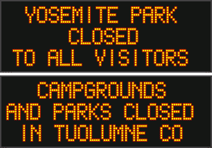
Arnold, CA…From the National Weather Service…Snow Showers and Strong Wind for Higher Mountain Elevations into Tuesday. Late season Pacific storm will bring periods of moderate snow and strong wind to the higher elevations of the Sierra Nevada and mountains of Western Plumas County into Tuesday. Travel into the mountains should be avoided during this time period as slick roads, lowered visibility, travel delays and chain controls are expected.
CAZ069-190000-
/O.CON.KSTO.WS.W.0005.000000T0000Z-200520T0000Z/
West Slope Northern Sierra Nevada-
302 AM PDT Mon May 18 2020
…WINTER STORM WARNING REMAINS IN EFFECT UNTIL 5 PM PDT TUESDAY
ABOVE 6500 FEET…
* WHAT…Heavy snow occurring. Plan on difficult travel
conditions, including during the morning commute. Additional
snow accumulations of 7 to 10 inches, with localized amounts
up to 15 inches, are expected.
* WHERE…West Slope Northern Sierra Nevada including Donner Pass
and Echo Summit.
* WHEN…Until 5 PM Tuesday.
* ADDITIONAL DETAILS…Be prepared for significant reductions in
visibility at times.
PRECAUTIONARY/PREPAREDNESS ACTIONS…
A Winter Storm Warning for snow means there will be snow covered
roads and limited visibilities. Travel is not recommended while
the warning is in effect. If you must travel, keep an extra
flashlight, food and water in your vehicle in case of an
emergency.The latest road conditions for the state you are
calling from can be obtained by calling 5 1 1.
$$
Flash Flood Watch
Flood Watch
National Weather Service Sacramento CA
250 AM PDT Mon May 18 2020
CAZ013-015>017-019-063-066>069-190400-
/O.CON.KSTO.FF.A.0001.200518T1700Z-200519T0400Z/
/00000.0.ER.000000T0000Z.000000T0000Z.000000T0000Z.OO/
Shasta Lake Area / Northern Shasta County-
Northern Sacramento Valley-Central Sacramento Valley-
Southern Sacramento Valley-Northern San Joaquin Valley-
Mountains Southwestern Shasta County to Western Colusa County-
Northeast Foothills/Sacramento Valley-Motherlode-
Western Plumas County/Lassen Park-
West Slope Northern Sierra Nevada-
250 AM PDT Mon May 18 2020
…FLASH FLOOD WATCH REMAINS IN EFFECT FROM 10 AM PDT THIS
MORNING THROUGH THIS EVENING…
The Flash Flood Watch continues for
* A portion of northern California…including the following
areas…Central Sacramento Valley…Motherlode…Mountains
Southwestern Shasta County to Western Colusa County…
Northeast Foothills/Sacramento Valley…Northern Sacramento
Valley…Northern San Joaquin Valley…Shasta Lake Area /
Northern Shasta County…Southern Sacramento Valley…West
Slope Northern Sierra Nevada and Western Plumas County/Lassen
Park.
* From 10 AM PDT this morning through this evening
* Some of the thunderstorms today will have intense downpours that
will have a chance of producing flash flooding in the Watch
area. Thunderstorms that develop over the northern end of the
Sacramento Valley will also be very slow moving which will
increase the risk of flash flooding.
* The watch area also includes but is not limited to the recent
burn scars of the Camp and Carr wildfires.
PRECAUTIONARY/PREPAREDNESS ACTIONS…
A Flash Flood Watch means that conditions may develop that lead
to flash flooding. Flash flooding is a VERY DANGEROUS SITUATION.
You should monitor later forecasts and be prepared to take action
should Flash Flood Warnings be issued.
&&
$$
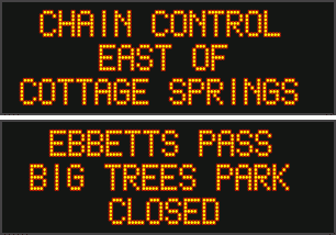
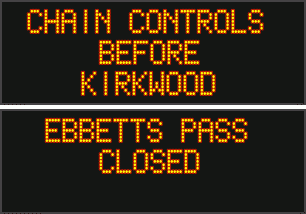
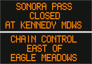
Winter Storm Warning & Late Season Storm Close Ebbetts & Sonora Passes Again added by admin on
View all posts by admin →