


Arnold, CA…The National Weather Service in Sacramento has elevated the weather warnings for our area from a Fire Weather Watch to a Red Flag Warning. This may also trigger a PSPS Event for our area for Sunday Evening with Power restoral time of 6pm on Monday.
Red Flag Warning
URGENT – FIRE WEATHER MESSAGE
National Weather Service Sacramento CA
1008 AM PDT Fri Sep 25 2020
…Critical Fire Weather Conditions Late Saturday Evening through
Monday Morning…
.Gusty northerly and easterly winds will develop over portions of
the Sacramento Valley, the northern Sierra and western foothills,
and the Coastal Range late Saturday evening into Monday morning.
Daytime humidities will be extremely low in the single digits to
teens with poor overnight humidity recoveries. The combination of
wind, low humidity, and hot conditions will result in critical fire
weather conditions. These conditions may impact ongoing wildfires.
Extreme caution should be taken to prevent new fire starts.
CAZ213-215>221-263-266>269-279-261200-
/O.UPG.KSTO.FW.A.0006.200926T1800Z-200928T1500Z/
/O.NEW.KSTO.FW.W.0009.200927T0400Z-200928T1900Z/
Eastern Portion of Shasta/Trinity NF-
Northern Sacramento Valley to Southern Tehama County Line Below
1000 Ft-
Central Sacramento Valley in Glenn, Colusa, Yuba, Northern
Sutter, and Butte County Below 1000 Ft-
Southern Sacramento Valley in Yolo-
Sacramento Far Western Placer, southern Sutter and Solano County
Below 1000 Ft-Carquinez Strait and Delta-
Northern San Joaquin Valley in San Joaquin and Stanislaus
Counties Below 1000 ft-
Southern Motherlode From 1000 to 3000 Ft. Includes portions of
Calaveras-Tuolumne Unit-Stanislaus NF West of the Sierra Crest-
Southeast Edge Shasta-Trinity NF and Western Portions of Tehama-
Glenn Unit-
Northern Sierra Foothills from 1000 to 3000 Ft. Includes portions
of Shasta-Trinity and Butte Units-
Northern Motherlode From 1000 to 3000 Ft. Includes portions of
Nevada-Yuba-Placer-Amador and ElDorado Units-
Northern Sierra Including Lassen NP and Plumas and Lassen NF/S
West of the Sierra Crest (West of Evans Peak-Grizzly Peak-
Beckworth Peak)-
Northern Sierra Including the Tahoe and ElDorado NF/S West of the
Sierra Crest-Eastern Mendocino NF-
1008 AM PDT Fri Sep 25 2020
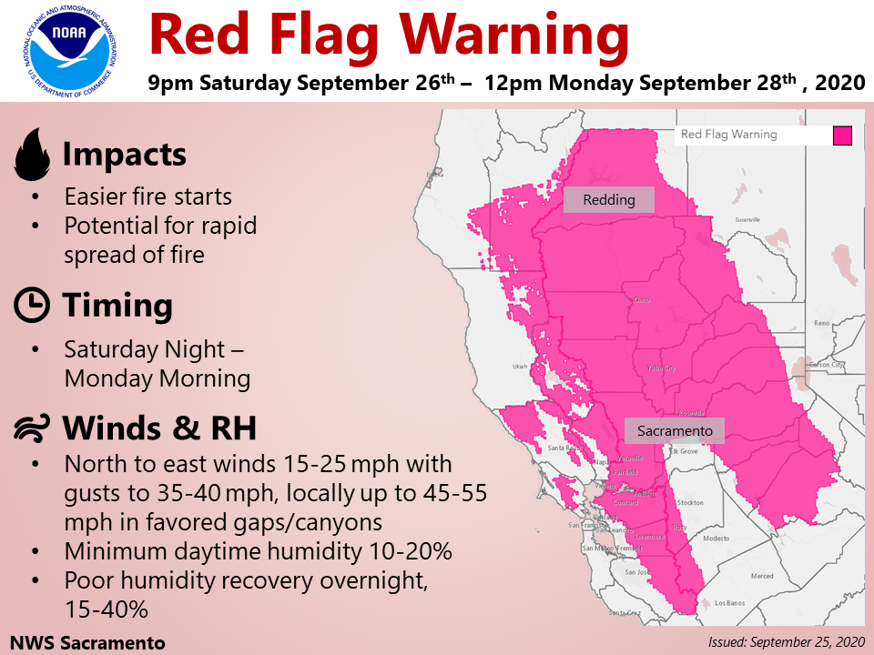
…RED FLAG WARNING IN EFFECT FROM 9 PM SATURDAY TO NOON PDT
MONDAY FOR GUSTY NORTH TO EAST WINDS AND LOW HUMIDITY FOR FIRE
WEATHER ZONES 213, 215, 216, 217, 218, 219, 220, 221, 263, 266,
267, 268, 269, AND 279…
The National Weather Service in Sacramento has issued a Red Flag
Warning, which is in effect from 9 PM Saturday to noon PDT
Monday. The Fire Weather Watch is no longer in effect.
* AFFECTED AREA…Portions of interior northern California including
the west side of the Sacramento Valley, the Coastal Range, the
western Sierra Nevada and foothills, and the Delta.
* WIND…North to east winds 15 to 25 mph with gusts up to 35 to 40
mph. Stronger gusts up to 45 to 55 mph may be possible through
favored gaps and canyons. Strongest winds expected Saturday night
through Sunday, especially for the west side of the Sacramento
Valley and the Sierra foothills.
* HUMIDITY…Minimum daytime humidity of 10 to 20 percent. Maximum
overnight humidity between 15 and 40 percent. Higher humidity
recovery expected in the Central Valley and Delta areas.
* IMPACTS…Numerous wildfires are already occurring. Extreme fire
safety precautions should be exercised to prevent any additional
fires. Outdoor burning should be avoided.
PRECAUTIONARY/PREPAREDNESS ACTIONS…
A Red Flag Warning means that critical fire weather conditions
are either occurring now, or will shortly. A combination of
strong winds, low relative humidity, and warm temperatures can
contribute to extreme fire behavior.
&&
Interact with us via social media
www.facebook.com/nws.sacramento
www.twitter.com/nwssacramento
$$
National Weather Service Issues Red Flag Warning for Our Area. May Trigger Sunday Eve PSPS Event added by admin on
View all posts by admin →