


Arnold, CA…Winter Storm Warning from Tuesday Afternoon to Wednesday Evening. Up to 2 Feet of Snow Expected.
Significant high elevation snow forecast Tuesday and Wednesday…
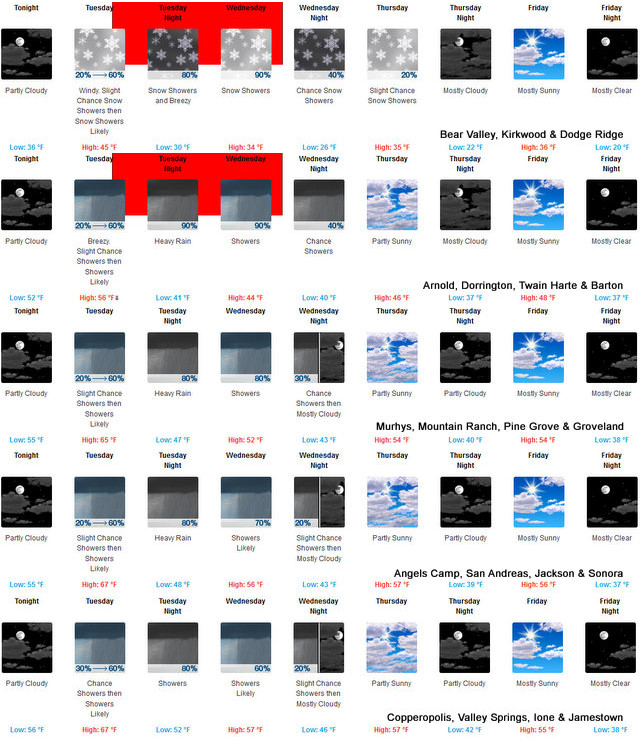

.A storm system will move into the region on Tuesday, spreading
south during the day. Snow levels will start out around 6000 to
7000 feet Tuesday, then lower slightly Wednesday. 1 to 2 feet of
snow are expected along the crest of the northern Sierra, and over
the higher elevations of the southern Cascade Range. In addition
to the heavy snow, strong gusty southwest winds will occur.
Significant disruptions to travel are likely across the northern
Sierra highway passes late Tuesday into Wednesday.
Winter Storm Warning
URGENT – WINTER WEATHER MESSAGE
National Weather Service Sacramento CA
230 AM PST Mon Nov 16 2020
…Significant high elevation snow forecast Tuesday and
Wednesday…
.A storm system will move into the region on Tuesday, spreading
south during the day. Snow levels will start out around 6000 to
7000 feet Tuesday, then lower slightly Wednesday. 1 to 2 feet of
snow are expected along the crest of the northern Sierra, and over
the higher elevations of the southern Cascade Range. In addition
to the heavy snow, strong gusty southwest winds will occur.
Significant disruptions to travel are likely across the northern
Sierra highway passes late Tuesday into Wednesday.
CAZ069-170000-
/O.UPG.KSTO.WS.A.0006.201117T2300Z-201119T0000Z/
/O.NEW.KSTO.WS.W.0007.201117T2200Z-201119T0200Z/
West Slope Northern Sierra Nevada-
230 AM PST Mon Nov 16 2020
…WINTER STORM WARNING IN EFFECT FROM 2 PM TUESDAY TO 6 PM PST
WEDNESDAY ABOVE 6500 FEET…
* WHAT…Heavy snow expected. Travel will be very difficult.
Damage to trees and power lines is possible. Total snow
accumulations of 12 to 18 inches at pass level, with localized
amounts up to 2 feet over the peaks, are expected.
* WHERE…West Slope Northern Sierra Nevada including Interstate
80 over Donner Pass, Highway 50 over Echo Summit and Highway 88
over Carson Pass.
* WHEN…2 PM Tuesday to 6 PM Wednesday.
* ADDITIONAL DETAILS…Be prepared for significant reductions in
visibility at times. Strong winds are expected Tuesday and
Tuesday night with gusts of 50 to 60 mph possible across the
higher elevations.
PRECAUTIONARY/PREPAREDNESS ACTIONS…
A Winter Storm Warning for wet snow means there will be snow
covered roads and limited visibilities. Travel is not recommended
while the warning is in effect. If you must travel, keep an extra
flashlight, food and water in your vehicle in case of an
emergency.The latest road conditions for the state you are
calling from can be obtained by calling 5 1 1.
$$
Winter Storm Warning from Tuesday Afternoon to Wednesday Evening. Up to 2 Feet of Snow Expected added by admin on
View all posts by admin →