


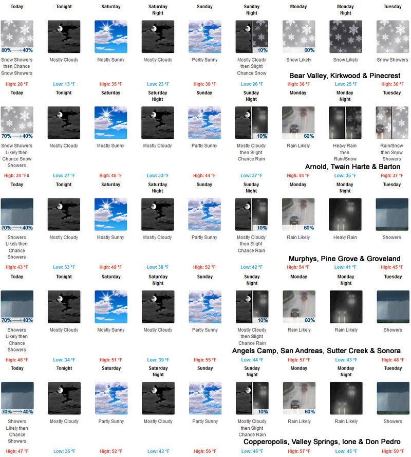
Arnold, CA…Detailed forecasts from the National Weather Service for West Slope Northern Sierra Nevada & Mother Lode are below. For the West Slope Today Mostly cloudy. Snow showers likely in the morning, then a chance of rain and snow showers in the afternoon. Not as cold. Highs 23 to 38 higher elevations…34 to 42 lower elevations. Snow accumulation up to 3 inches. Snow level 3000 to 3500 feet. prevailing south winds up to 10 mph. Tonight, Mostly cloudy. Colder. Lows 10 to 25 higher elevations…23 to 33 lower elevations. Prevailing southeast winds up to 10 mph.
Saturday
Partly cloudy in the morning then clearing. Not as cool. Highs 28 to 43 higher elevations…38 to 48 lower elevations. Prevailing south winds up to 10 mph.
Saturday Night
Partly cloudy in the evening, then mostly cloudy with a slight chance of snow after midnight. Lows 19 to 34 higher elevations…31 to 39 lower elevations. Prevailing southeast winds up to 10 mph.
Sunday
Mostly cloudy. A chance of rain and snow in the morning, then a slight chance of snow in the afternoon. Not as cool. Highs 31 to 46 higher elevations…42 to 52 lower elevations. Snow level 5000 feet. Prevailing south winds up to 15 mph.
Sunday Night
Mostly cloudy with a slight chance of rain and snow. Lows 26 to 41.
Monday
Mostly cloudy with a chance of rain and snow. Highs 34 to 49.
Monday Night
Heavy rain and snow. Colder. Heavy snow accumulations possible. Lows 23 to 38.
Tuesday
Snow showers and heavy rain showers. Heavy snow accumulations possible. Highs 28 to 43.
Tuesday Night
Mostly cloudy with a chance of snow showers. Colder. Lows 14 to 29.
Wednesday
Partly cloudy with a slight chance of snow showers. Highs 28 to 43.
Wednesday Night
Mostly clear. Lows 15 to 30.
Thursday
Sunny. Not as cool. Highs 34 to 49.
Detailed forecast for Motherlode Today
Mostly cloudy. Rain and snow showers likely in the morning, then a chance of rain showers in the afternoon. Highs 39 to 51. No snow accumulation. Light winds.
Tonight
Mostly cloudy. Lows 28 to 40. Light winds.
Saturday
Mostly cloudy in the morning then becoming partly cloudy. Highs 45 to 55. Light winds.
Saturday Night
Mostly cloudy. A slight chance of rain after midnight. Lows 34 to 44. Light winds.
Sunday
Mostly cloudy. A chance of rain in the morning, then a slight chance of rain in the afternoon. Highs 48 to 58. Prevailing south winds up to 10 mph.
Sunday Night
Mostly cloudy with a slight chance of rain. Lows 38 to 48.
Monday
Mostly cloudy with a chance of rain. Highs 47 to 59.
Monday Night
Heavy rain likely. Lows 36 to 46.
Tuesday
Rain showers. Highs 42 to 52.
Tuesday Night
Mostly cloudy with a chance of rain and snow showers. Colder. Lows 28 to 38.
Wednesday
Partly cloudy with a slight chance of rain and snow showers. Highs 44 to 54.
Wednesday Night
Mostly clear. Lows 29 to 37.
Thursday
Sunny. Highs 47 to 57.
A Weekend Break & Then Moisture Returns Along West Slope & Mother Lode added by admin on
View all posts by admin →