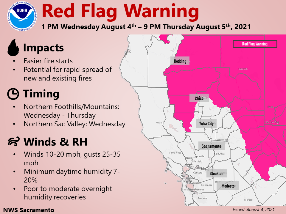
Sacramento, CA…The Red Flag Warning has been expanded for portions of Northern California for this afternoon – tomorrow evening. Breezy winds & extremely dry conditions will create critical fire weather conditions. Are you prepared for wildfire? Visit readyforwildfire.org for preparedness tips. The full Red Flag Warning is below…
Red Flag Warning
URGENT – FIRE WEATHER MESSAGE
National Weather Service Sacramento CA
1008 PM PDT Wed Aug 4 2021
…Red Flag Warning for Gusty Wind and Very Low Humidity this
Afternoon through Thursday Evening…
.Low pressure area moving through the region on Thursday will
bring shifting gusty winds, very low humidity, and extremely dry
fuels combine to bring critical fire weather conditions over the
Northern and Central Sacramento Valley, Coastal Range mountains
tonight as well as in the northeast foothills and mountains of
eastern Shasta and Western Plumas counties and the Northern Sierra
Nevada through Thursday evening. Relative humidity levels
gradually increase over low elevations on Thursday, with higher
elevations remaining dry and winds increasing again during the day
before becoming lighter in the evening.
CAZ214-221-266-268-269-051315-
/O.CON.KSTO.FW.W.0005.000000T0000Z-210806T0400Z/
Burney Basin and Northeast Plateau in Shasta County Including
Northwest Lassen NF north of Lassen NP-
Stanislaus NF West of the Sierra Crest-
Northern Sierra Foothills from 1000 to 3000 Ft. Includes portions
of Shasta-Trinity and Butte Units-
Northern Sierra Including Lassen NP and Plumas and Lassen NF/S
West of the Sierra Crest (West of Evans Peak-Grizzly Peak-
Beckworth Peak)-
Northern Sierra Including the Tahoe and ElDorado NF/S West of the
Sierra Crest-
1008 PM PDT Wed Aug 4 2021
…RED FLAG WARNING REMAINS IN EFFECT UNTIL 9 PM PDT THURSDAY FOR
GUSTY WIND AND LOW HUMIDITY FOR FIRE WEATHER ZONES 214, 266, AND
268…
* AFFECTED AREA…The Burney Basin, northeast foothills, Lassen
National Park, and mountains of western Plumas County and of
eastern Shasta County.
* WIND…Southwest 10 to 20 mph with local gusts up to 35 mph,
locally higher. Strongest wind expected afternoons into
evenings. Wind shifts to the west northwest late day Thursday.
* HUMIDITY…Minimum humidity in the single digits to mid
teens. Overnight humidity recoveries 20 to 45 percent.
* IMPACTS…Any fires that develop will likely spread rapidly.
Outdoor burning is not recommended.
PRECAUTIONARY/PREPAREDNESS ACTIONS…
A Red Flag Warning means that critical fire weather conditions
are either occurring now, or will shortly. A combination of
strong winds, low relative humidity, and warm temperatures can
contribute to extreme fire behavior.
&&
Interact with us via social media
www.facebook.com/nws.sacramento
www.twitter.com/nwssacramento
$$


