


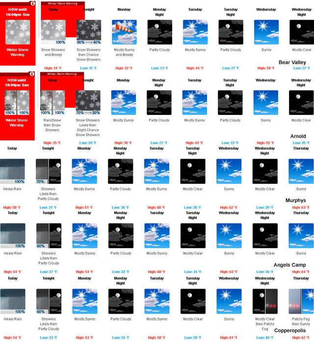
Bear Valley, CA…Today At lower elevations…rain in the morning…then heavy rain showers…heavy snow showers and a slight chance of thunderstorms in the afternoon. At higher elevations…snow and heavy rain likely in the morning…then snow showers in the afternoon. Cooler. Highs 28 to 40 higher elevations…39 to 45 lower elevations. Snow accumulation 4 to 8 inches lower elevations…6 to 12 inches higher elevations. Snow level 5000 feet. Prevailing southwest winds 10 to 20 mph with gusts to around 35 mph. Over ridges…prevailing southwest winds 35 to 55 mph with gusts to around 70 mph decreasing to 15 to 30 mph in the afternoon.
Tonight
Mostly cloudy. Rain and snow showers likely in the evening…then a slight chance of snow showers after midnight. Colder. Lows 10 to 25 higher elevations…20 to 34 lower elevations. Additional snow accumulation up to 4 inches. Snow level 4000 feet. Prevailing northwest winds 5 to 15 mph shifting to the north after midnight.
Monday
Partly cloudy. Highs 26 to 41 higher elevations…40 to 46 lower elevations. Prevailing northeast winds 10 to 20 mph with gusts to around 35 mph.
Monday Night
Partly cloudy. Lows 18 to 33 higher elevations… 30 to 38 lower elevations. Prevailing northeast winds up to 15 mph. Over ridges…prevailing northeast winds 10 to 20 mph increasing to 15 to 30 mph after midnight.
Tuesday
Partly cloudy. Not as cool. Highs 38 to 53 higher elevations…52 to 58 lower elevations. Prevailing northeast winds up to 15 mph. Over ridges…prevailing north winds 15 to 30 mph shifting to the northeast 10 to 20 mph in the afternoon.
Tuesday Night
Mostly clear. Lows 27 to 42.
Wednesday
Mostly sunny. Not as cool. Highs 47 to 62.
Wednesday Night Through Friday Night
Mostly clear. Lows 27 to 42. Highs 47 to 62.
Saturday
Partly cloudy with a slight chance of rain showers. Highs 44 to 59.
Another Brief Shot Of Winter Will Roll Through Today added by admin on
View all posts by admin →