


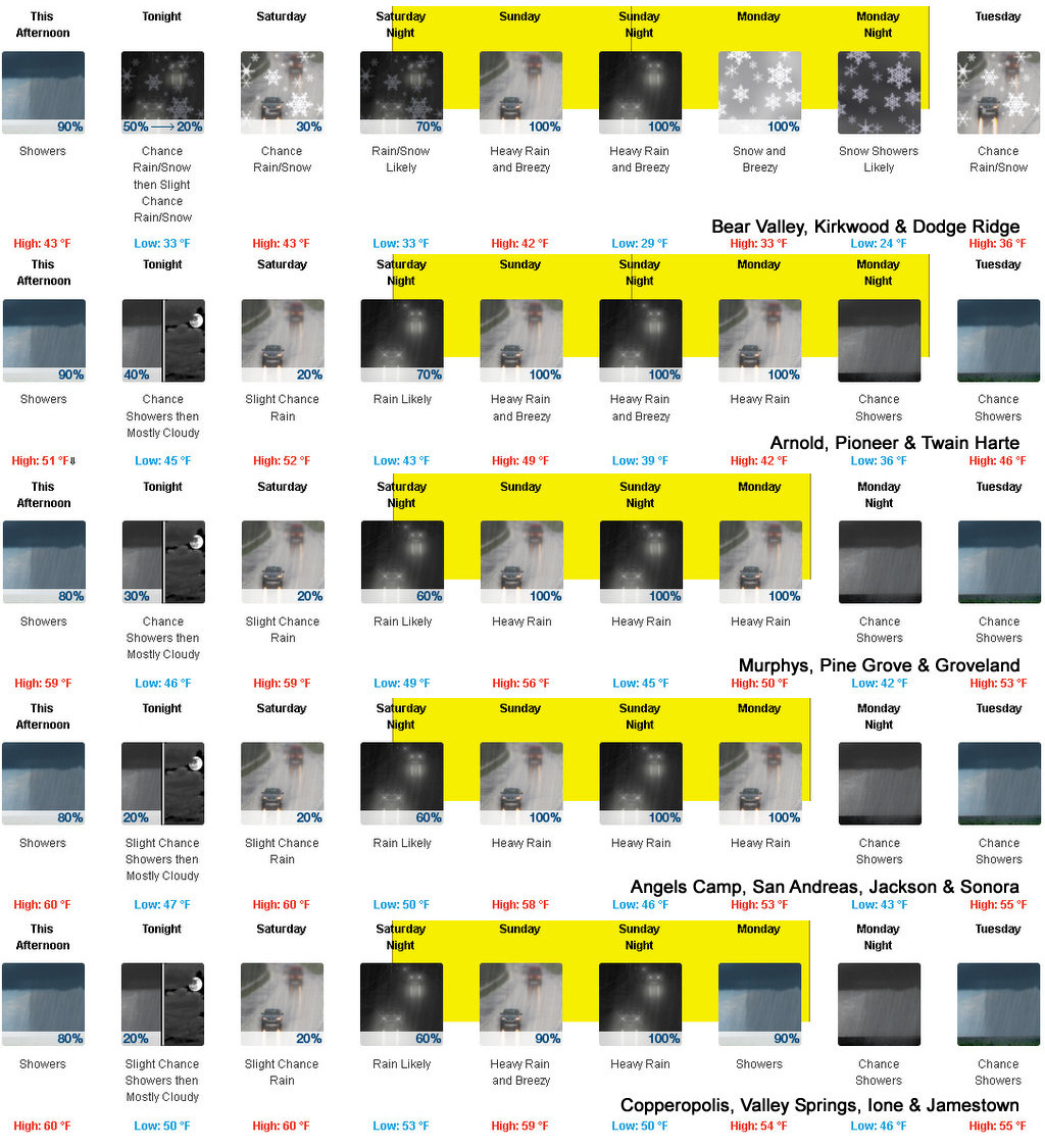
Arnold, CA…Ladies & Gentlemen, Lads & Lasses and Boys & Girls….The Drought & Fire Season has been replaced at least for the next week or so with Winter Storm Watches & Flood Warnings. The latest from the National Weather Service is below…
weather.gov
National Weather Service
Watches, Warnings & Advisories
Go to the NOAA Homepage
NWS Homepage
Local weather forecast by “City, St” or zip code
4 products issued by NWS for: 15 Miles NE Murphys CA
Share
|
Winter Storm Watch
URGENT – WINTER WEATHER MESSAGE
National Weather Service Sacramento CA
230 AM PDT Fri Oct 22 2021
…Winter storm will bring heavy mountain snow Sunday night
through early Tuesday morning…
.A strong winter storm will impact the northern Sierra late
Sunday night through early Tuesday morning. Snow levels will
quickly fall from above pass level Sunday evening to around
6,000 feet by early Monday. Periods of heavy snowfall and gusty
winds will create hazardous travel conditions. Expect mountain
travel impacts such as chain controls and travel delays.
CAZ068-069-222300-
/O.CON.KSTO.WS.A.0007.211025T0600Z-211026T1200Z/
Western Plumas County/Lassen Park-
West Slope Northern Sierra Nevada-
230 AM PDT Fri Oct 22 2021
…WINTER STORM WATCH REMAINS IN EFFECT FROM SUNDAY EVENING
THROUGH LATE MONDAY NIGHT ABOVE 6000 FEET…
* WHAT…Heavy snow possible. Travel will be very difficult. Tree
branches could fall as well. Total snow accumulations of 1 to 2
feet, with localized amounts up to 3 feet, are possible.
* WHERE…Western Plumas County/Lassen Park and West Slope
Northern Sierra Nevada including Interstate 80 over Donner Pass,
Highway 50 over Echo Summit and Highway 88 over Carson Pass.
* WHEN…From Sunday evening through late Monday night.
* ADDITIONAL DETAILS…Significant reductions in visibility are
possible.
PRECAUTIONARY/PREPAREDNESS ACTIONS…
A Winter Storm Watch means there is potential for significant
snow, sleet or ice accumulations that may impact travel. Continue
to monitor the latest forecasts.
$$
Flash Flood Watch
Flood Watch
National Weather Service Sacramento CA
109 PM PDT Fri Oct 22 2021
.Periods of heavy rain are expected Sunday morning through Monday
morning. This could bring potential ash and debris flows over recent
burn scar areas. Potential rainfall rates will be over a half inch
per hour. Snow levels will be high, decreasing late Sunday night to
around 6000 feet.
A Flood Watch has been issued for interior Northern California from
Saturday evening through Monday afternoon. Long duration moderate to
heavy rain may lead to urban and small stream flooding during this
time.
CAZ069-231415-
/O.NEW.KSTO.FF.A.0004.211024T1200Z-211025T1200Z/
/00000.0.ER.000000T0000Z.000000T0000Z.000000T0000Z.OO/
/O.NEW.KSTO.FA.A.0002.211025T1200Z-211026T0000Z/
/00000.0.ER.000000T0000Z.000000T0000Z.000000T0000Z.OO/
/O.EXT.KSTO.FA.A.0001.211024T0600Z-211024T1200Z/
/00000.0.ER.000000T0000Z.000000T0000Z.000000T0000Z.OO/
West Slope Northern Sierra Nevada-
Including the cities of Blue Canyon
109 PM PDT Fri Oct 22 2021
…FLOOD WATCH NOW IN EFFECT FROM SATURDAY EVENING THROUGH LATE
SATURDAY NIGHT…
…FLASH FLOOD WATCH IN EFFECT FOR THE CALDOR BURN SCAR FROM LATE
SATURDAY NIGHT THROUGH LATE SUNDAY NIGHT…
…FLOOD WATCH IN EFFECT FROM LATE SUNDAY NIGHT THROUGH MONDAY
AFTERNOON…
The Flood Watch is now in effect for
* A portion of northern California, including the following area,
West Slope Northern Sierra Nevada.
* From Saturday evening through late Saturday night.
* Periods of moderate to heavy rain are expected late Saturday night
through Monday.
PRECAUTIONARY/PREPAREDNESS ACTIONS…
You should monitor later forecasts and be alert for possible Flood
Warnings. Those living in areas prone to flooding should be prepared
to take action should flooding develop.
&&
The National Weather Service in Sacramento has issued a
* Flash Flood Watch for the El Dorado County portion of the Caldor
Burn Scar in northern California.
* From late Saturday night through late Sunday night.
* Periods of heavy rainfall are forecasted over the Caldor burn
scar, which may lead to flash flooding and debris flows.
The National Weather Service in Sacramento has issued a
* Flood Watch for a portion of northern California, including the
following area, West Slope Northern Sierra Nevada.
* From late Sunday night through Monday afternoon.
* Periods of moderate to heavy rain are expected late Saturday night
through Monday.
PRECAUTIONARY/PREPAREDNESS ACTIONS…
You should monitor later forecasts and be alert for possible Flood
Warnings. Those living in areas prone to flooding should be prepared
to take action should flooding develop.
&&
$$
Flood Watch
Flood Watch
National Weather Service Sacramento CA
109 PM PDT Fri Oct 22 2021
.Periods of heavy rain are expected Sunday morning through Monday
morning. This could bring potential ash and debris flows over recent
burn scar areas. Potential rainfall rates will be over a half inch
per hour. Snow levels will be high, decreasing late Sunday night to
around 6000 feet.
A Flood Watch has been issued for interior Northern California from
Saturday evening through Monday afternoon. Long duration moderate to
heavy rain may lead to urban and small stream flooding during this
time.
CAZ069-231415-
/O.NEW.KSTO.FF.A.0004.211024T1200Z-211025T1200Z/
/00000.0.ER.000000T0000Z.000000T0000Z.000000T0000Z.OO/
/O.NEW.KSTO.FA.A.0002.211025T1200Z-211026T0000Z/
/00000.0.ER.000000T0000Z.000000T0000Z.000000T0000Z.OO/
/O.EXT.KSTO.FA.A.0001.211024T0600Z-211024T1200Z/
/00000.0.ER.000000T0000Z.000000T0000Z.000000T0000Z.OO/
West Slope Northern Sierra Nevada-
Including the cities of Blue Canyon
109 PM PDT Fri Oct 22 2021
…FLOOD WATCH NOW IN EFFECT FROM SATURDAY EVENING THROUGH LATE
SATURDAY NIGHT…
…FLASH FLOOD WATCH IN EFFECT FOR THE CALDOR BURN SCAR FROM LATE
SATURDAY NIGHT THROUGH LATE SUNDAY NIGHT…
…FLOOD WATCH IN EFFECT FROM LATE SUNDAY NIGHT THROUGH MONDAY
AFTERNOON…
The Flood Watch is now in effect for
* A portion of northern California, including the following area,
West Slope Northern Sierra Nevada.
* From Saturday evening through late Saturday night.
* Periods of moderate to heavy rain are expected late Saturday night
through Monday.
PRECAUTIONARY/PREPAREDNESS ACTIONS…
You should monitor later forecasts and be alert for possible Flood
Warnings. Those living in areas prone to flooding should be prepared
to take action should flooding develop.
&&
The National Weather Service in Sacramento has issued a
* Flash Flood Watch for the El Dorado County portion of the Caldor
Burn Scar in northern California.
* From late Saturday night through late Sunday night.
* Periods of heavy rainfall are forecasted over the Caldor burn
scar, which may lead to flash flooding and debris flows.
The National Weather Service in Sacramento has issued a
* Flood Watch for a portion of northern California, including the
following area, West Slope Northern Sierra Nevada.
* From late Sunday night through Monday afternoon.
* Periods of moderate to heavy rain are expected late Saturday night
through Monday.
PRECAUTIONARY/PREPAREDNESS ACTIONS…
You should monitor later forecasts and be alert for possible Flood
Warnings. Those living in areas prone to flooding should be prepared
to take action should flooding develop.
&&
$$
U.S. Dept. of Commerce
NOAA National Weather Service
1325 East West Highway
Silver Spring, MD 20910
E-mail: w-nws.webmaster@noaa.gov
Page last modified: May 16, 2007
Disclaimer
Credits
Glossary
Privacy Policy
About Us
Career Opportunities
NATIONAL WEATHER SERVICE: for Safety, for Work, for Fun – FOR LIFE
Flood Watch
Flood Watch
National Weather Service Sacramento CA
109 PM PDT Fri Oct 22 2021
.Periods of heavy rain are expected Sunday morning through Monday
morning. This could bring potential ash and debris flows over recent
burn scar areas. Potential rainfall rates will be over a half inch
per hour. Snow levels will be high, decreasing late Sunday night to
around 6000 feet.
A Flood Watch has been issued for interior Northern California from
Saturday evening through Monday afternoon. Long duration moderate to
heavy rain may lead to urban and small stream flooding during this
time.
CAZ067-231415-
/O.NEW.KSTO.FF.A.0004.211024T1200Z-211025T1200Z/
/00000.0.ER.000000T0000Z.000000T0000Z.000000T0000Z.OO/
/O.NEW.KSTO.FA.A.0002.211025T1200Z-211026T0000Z/
/00000.0.ER.000000T0000Z.000000T0000Z.000000T0000Z.OO/
/O.EXT.KSTO.FA.A.0001.211024T0600Z-211024T1200Z/
/00000.0.ER.000000T0000Z.000000T0000Z.000000T0000Z.OO/
Motherlode-
Including the cities of Jackson and Grass Valley
109 PM PDT Fri Oct 22 2021
…FLOOD WATCH NOW IN EFFECT FROM SATURDAY EVENING THROUGH LATE
SATURDAY NIGHT…
…FLASH FLOOD WATCH IN EFFECT FOR THE RIVER BURN SCAR FROM LATE
SATURDAY NIGHT THROUGH LATE SUNDAY NIGHT…
…FLOOD WATCH IN EFFECT FROM LATE SUNDAY NIGHT THROUGH MONDAY
AFTERNOON…
The Flood Watch is now in effect for
* A portion of northern California, including the following area,
Motherlode.
* From Saturday evening through late Saturday night.
* Periods of moderate to heavy rain are expected late Saturday night
through Monday.
PRECAUTIONARY/PREPAREDNESS ACTIONS…
You should monitor later forecasts and be alert for possible Flood
Warnings. Those living in areas prone to flooding should be prepared
to take action should flooding develop.
&&
The National Weather Service in Sacramento has issued a
* Flash Flood Watch for the Placer and Nevada County portion of the
River Burn Scar in northern California.
* From late Saturday night through late Sunday night.
* Periods of heavy rainfall are forecasted over the River burn scar,
which may lead to flash flooding and debris flows.
The National Weather Service in Sacramento has issued a
* Flood Watch for a portion of northern California, including the
following area, Motherlode.
* From late Sunday night through Monday afternoon.
* Periods of moderate to heavy rain are expected late Saturday night
through Monday.
PRECAUTIONARY/PREPAREDNESS ACTIONS…
You should monitor later forecasts and be alert for possible Flood
Warnings. Those living in areas prone to flooding should be prepared
to take action should flooding develop.
&&
$$
Flood Watch
Flood Watch
National Weather Service Sacramento CA
109 PM PDT Fri Oct 22 2021
.Periods of heavy rain are expected Sunday morning through Monday
morning. This could bring potential ash and debris flows over recent
burn scar areas. Potential rainfall rates will be over a half inch
per hour. Snow levels will be high, decreasing late Sunday night to
around 6000 feet.
A Flood Watch has been issued for interior Northern California from
Saturday evening through Monday afternoon. Long duration moderate to
heavy rain may lead to urban and small stream flooding during this
time.
CAZ067-231415-
/O.NEW.KSTO.FF.A.0004.211024T1200Z-211025T1200Z/
/00000.0.ER.000000T0000Z.000000T0000Z.000000T0000Z.OO/
/O.NEW.KSTO.FA.A.0002.211025T1200Z-211026T0000Z/
/00000.0.ER.000000T0000Z.000000T0000Z.000000T0000Z.OO/
/O.EXT.KSTO.FA.A.0001.211024T0600Z-211024T1200Z/
/00000.0.ER.000000T0000Z.000000T0000Z.000000T0000Z.OO/
Motherlode-
Including the cities of Jackson and Grass Valley
109 PM PDT Fri Oct 22 2021
…FLOOD WATCH NOW IN EFFECT FROM SATURDAY EVENING THROUGH LATE
SATURDAY NIGHT…
…FLASH FLOOD WATCH IN EFFECT FOR THE RIVER BURN SCAR FROM LATE
SATURDAY NIGHT THROUGH LATE SUNDAY NIGHT…
…FLOOD WATCH IN EFFECT FROM LATE SUNDAY NIGHT THROUGH MONDAY
AFTERNOON…
The Flood Watch is now in effect for
* A portion of northern California, including the following area,
Motherlode.
* From Saturday evening through late Saturday night.
* Periods of moderate to heavy rain are expected late Saturday night
through Monday.
PRECAUTIONARY/PREPAREDNESS ACTIONS…
You should monitor later forecasts and be alert for possible Flood
Warnings. Those living in areas prone to flooding should be prepared
to take action should flooding develop.
&&
The National Weather Service in Sacramento has issued a
* Flash Flood Watch for the Placer and Nevada County portion of the
River Burn Scar in northern California.
* From late Saturday night through late Sunday night.
* Periods of heavy rainfall are forecasted over the River burn scar,
which may lead to flash flooding and debris flows.
The National Weather Service in Sacramento has issued a
* Flood Watch for a portion of northern California, including the
following area, Motherlode.
* From late Sunday night through Monday afternoon.
* Periods of moderate to heavy rain are expected late Saturday night
through Monday.
PRECAUTIONARY/PREPAREDNESS ACTIONS…
You should monitor later forecasts and be alert for possible Flood
Warnings. Those living in areas prone to flooding should be prepared
to take action should flooding develop.
&&
$$
Flash Flood Watch
Flood Watch
National Weather Service Sacramento CA
109 PM PDT Fri Oct 22 2021
.Periods of heavy rain are expected Sunday morning through Monday
morning. This could bring potential ash and debris flows over recent
burn scar areas. Potential rainfall rates will be over a half inch
per hour. Snow levels will be high, decreasing late Sunday night to
around 6000 feet.
A Flood Watch has been issued for interior Northern California from
Saturday evening through Monday afternoon. Long duration moderate to
heavy rain may lead to urban and small stream flooding during this
time.
CAZ067-231415-
/O.NEW.KSTO.FF.A.0004.211024T1200Z-211025T1200Z/
/00000.0.ER.000000T0000Z.000000T0000Z.000000T0000Z.OO/
/O.NEW.KSTO.FA.A.0002.211025T1200Z-211026T0000Z/
/00000.0.ER.000000T0000Z.000000T0000Z.000000T0000Z.OO/
/O.EXT.KSTO.FA.A.0001.211024T0600Z-211024T1200Z/
/00000.0.ER.000000T0000Z.000000T0000Z.000000T0000Z.OO/
Motherlode-
Including the cities of Jackson and Grass Valley
109 PM PDT Fri Oct 22 2021
…FLOOD WATCH NOW IN EFFECT FROM SATURDAY EVENING THROUGH LATE
SATURDAY NIGHT…
…FLASH FLOOD WATCH IN EFFECT FOR THE RIVER BURN SCAR FROM LATE
SATURDAY NIGHT THROUGH LATE SUNDAY NIGHT…
…FLOOD WATCH IN EFFECT FROM LATE SUNDAY NIGHT THROUGH MONDAY
AFTERNOON…
The Flood Watch is now in effect for
* A portion of northern California, including the following area,
Motherlode.
* From Saturday evening through late Saturday night.
* Periods of moderate to heavy rain are expected late Saturday night
through Monday.
PRECAUTIONARY/PREPAREDNESS ACTIONS…
You should monitor later forecasts and be alert for possible Flood
Warnings. Those living in areas prone to flooding should be prepared
to take action should flooding develop.
&&
The National Weather Service in Sacramento has issued a
* Flash Flood Watch for the Placer and Nevada County portion of the
River Burn Scar in northern California.
* From late Saturday night through late Sunday night.
* Periods of heavy rainfall are forecasted over the River burn scar,
which may lead to flash flooding and debris flows.
The National Weather Service in Sacramento has issued a
* Flood Watch for a portion of northern California, including the
following area, Motherlode.
* From late Sunday night through Monday afternoon.
* Periods of moderate to heavy rain are expected late Saturday night
through Monday.
PRECAUTIONARY/PREPAREDNESS ACTIONS…
You should monitor later forecasts and be alert for possible Flood
Warnings. Those living in areas prone to flooding should be prepared
to take action should flooding develop.
&&
Winter Storm Watches & Flood Warnings Ahead added by admin on
View all posts by admin →