


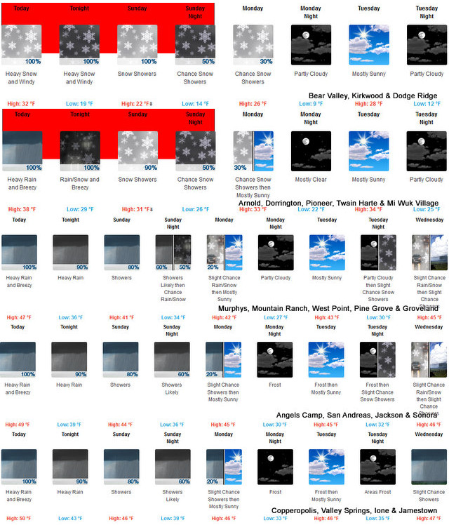
Arnold, CA…Heavy snow expected. Total snow accumulations of 2 to 5 feet, locally up to 6 feet possible. Winds gusting as high as 80 mph or more over higher terrain. Snow levels above 4500 to 5500 feet today, lowering to 2500 to 3000 feet Sunday. The majority of the snow accumulation will be above 4000 feet.
Winter Storm Warning
URGENT – WINTER WEATHER MESSAGE
National Weather Service Sacramento CA
200 AM PST Sat Dec 10 2022
CAZ014-068-069-110000-
/O.CON.KSTO.WS.W.0008.000000T0000Z-221212T1200Z/
Burney Basin / Eastern Shasta County-
Western Plumas County/Lassen Park-
West Slope Northern Sierra Nevada-
Including the cities of Burney, Chester, Quincy, and Blue Canyon
200 AM PST Sat Dec 10 2022
…WINTER STORM WARNING REMAINS IN EFFECT UNTIL 4 AM PST MONDAY…
* WHAT…Heavy snow expected. Total snow accumulations of 2 to 5
feet, locally up to 6 feet possible. Winds gusting as high as 80
mph or more over higher terrain.
* WHERE…West Slope Northern Sierra Nevada, including
Interstate 80 and Highway 50. Burney Basin / Eastern Shasta
County and Western Plumas County/Lassen Park.
* WHEN…Until 4 AM PST Monday.
* IMPACTS…Travel will be very difficult to impossible. Chain
controls, travel delays, and road closures are likely. Gusty
winds and heavy snow could bring down tree branches. Near
whiteout conditions at times.
* ADDITIONAL DETAILS…Snow levels above 4500 to 5500 feet today,
lowering to 2500 to 3000 feet Sunday. The majority of the snow
accumulation will be above 4000 feet.
PRECAUTIONARY/PREPAREDNESS ACTIONS…
If you must travel, keep an extra flashlight, food, and water in
your vehicle in case of an emergency.
The latest road conditions for the state you are calling from can
be obtained by calling 5 1 1.
Over 6 Feet of Snow Possible from This System at Higher Elevations added by admin on
View all posts by admin →