


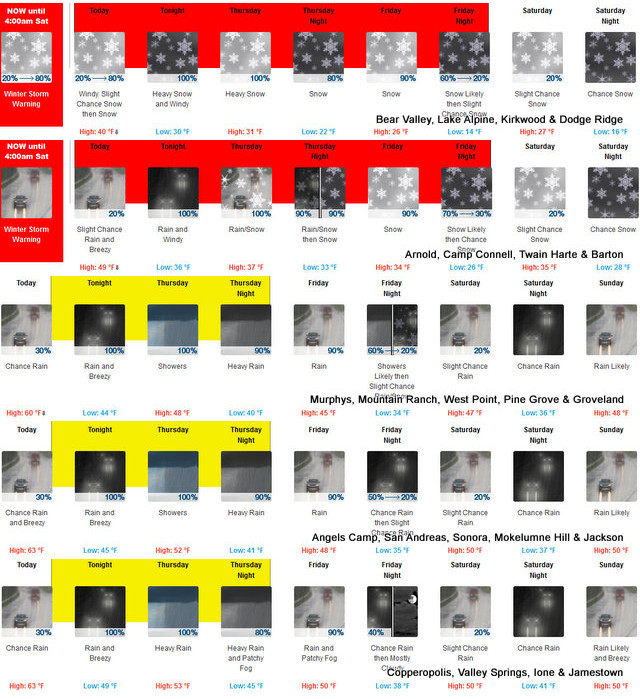
Arnold, CA…The latest from the National Weather Service….Heavy snow expected. Total snow accumulations of 1 to 2 feet, locally up to 3 feet at mountain peaks. Southerly winds gusting as high as 65 mph. Snow levels of 6000 to 7000 feet on Wednesday, lowering to 4000 to 5000 feet on Thursday, and as low as 3500 feet by Friday morning. Heaviest snowfall accumulations expected above 6000 feet. Snow rates of 1 to 2 inches per hour, heaviest tonight into Thursday morning.

URGENT – WINTER WEATHER MESSAGE
National Weather Service Sacramento CA
230 AM PST Wed Jan 31 2024
CAZ068-069-010000-
/O.CON.KSTO.WS.W.0006.240131T1800Z-240203T1200Z/
Western Plumas County/Lassen Park-
West Slope Northern Sierra Nevada-
Including the cities of Chester, Quincy, and Blue Canyon
230 AM PST Wed Jan 31 2024
…WINTER STORM WARNING REMAINS IN EFFECT FROM 10 AM THIS MORNING
TO 4 AM PST SATURDAY…
* WHAT…Heavy snow expected. Total snow accumulations of 1 to 2
feet, locally up to 3 feet at mountain peaks. Southerly winds
gusting as high as 65 mph.
* WHERE…Western Plumas County/Lassen Park and West Slope
Northern Sierra Nevada, including Interstate 80 over Donner
Pass and Highway 50 over Echo Summit.
* WHEN…From 10 AM this morning to 4 AM PST Saturday.
* IMPACTS…Travel will be very difficult to impossible from
travel delays, snow covered roads, and reduced visibility at
times, with possible chain controls and road closures. Gusty
winds could bring down tree branches and telephone poles.
* ADDITIONAL DETAILS…Snow levels of 6000 to 7000 feet on
Wednesday, lowering to 4000 to 5000 feet on Thursday, and as low
as 3500 feet by Friday morning. Heaviest snowfall accumulations
expected above 6000 feet. Snow rates of 1 to 2 inches per hour,
heaviest tonight into Thursday morning.
PRECAUTIONARY/PREPAREDNESS ACTIONS…
If you must travel, keep an extra flashlight, food, and water in
your vehicle in case of an emergency.
The latest road conditions for the state you are calling from can
be obtained by calling 5 1 1.
Flood Watch
Flood Watch
National Weather Service Sacramento CA
1009 AM PST Wed Jan 31 2024
CAZ015>017-063-066-067-011400-
/O.CON.KSTO.FA.A.0002.240201T0000Z-240202T1200Z/
/00000.0.ER.000000T0000Z.000000T0000Z.000000T0000Z.OO/
Northern Sacramento Valley-Central Sacramento Valley-Southern
Sacramento Valley-Mountains Southwestern Shasta County to Western
Colusa County-Northeast Foothills/Sacramento Valley-Motherlode-
Including the cities of Redding, Marysville/Yuba City, Alder
Springs, Jackson, Sacramento, Paradise, Chico, Grass Valley,
Oroville, and Red Bluff
1009 AM PST Wed Jan 31 2024
…FLOOD WATCH REMAINS IN EFFECT FROM 4 PM PST THIS AFTERNOON
THROUGH LATE THURSDAY NIGHT…
* WHAT…Flooding caused by excessive rainfall continues to be
possible.
* WHERE…A portion of northern California, including the following
areas, Motherlode, Mountains Southwestern Shasta County to Western
Colusa County, Northeast Foothills and Sacramento Valley.
* WHEN…From 4 PM PST this afternoon through late Thursday night.
* IMPACTS…Excessive runoff may result in flooding of rivers,
creeks, streams, and other low-lying and flood-prone locations.
Creeks and streams may rise out of their banks. Flooding may occur
in poor drainage and urban areas. Low-water crossings may be
flooded. Storm drains and ditches may become clogged with debris.
* ADDITIONAL DETAILS…
– Urban and small stream flooding from prolonged heavy rain
Wednesday afternoon through late Thursday night. Moderate
rises likely along the Upper Sacramento River system and
tributaries.
– http://www.weather.gov/safety/flood
PRECAUTIONARY/PREPAREDNESS ACTIONS…
You should monitor later forecasts and be alert for possible Flood
Warnings. Those living in areas prone to flooding should be prepared
to take action should flooding develop.
Winter Returns, Winter Storm Warning Now Through 4am Saturday! Flood Warnings at Lower Elevations added by admin on
View all posts by admin →