

Arnold, CA…This highway information is the latest reported by Caltrans as of Wednesday, March 12th, 2025 at 11:50 PM.
SR 4
[IN THE CENTRAL CALIFORNIA AREA]
Is closed from the Mt Reba Turnoff to the Jct of SR 89 /Ebbetts Pass/ (Alpine Co) – For the Winter – Motorists are advised to use an alternate route
Chains are required on single axle drive vehicles towing trailers from 8.4 mi west of Bogard Ranger Station to Bogard Ranger Station (Lassen Co)
Chains are required on all vehicles except 4-wheel-drive vehicles with snow tires on all 4 wheels from Arnold (Calaveras Co) the Mt Reba Turnoff (Alpine Co) Please research chain control locations as caltrans is currently working to update chain control descriptions for consistency with internet mapping, like google maps & mapquest.
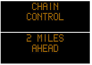
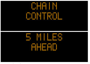
SR 88
[IN THE CENTRAL CALIFORNIA AREA & SIERRA NEVADA]
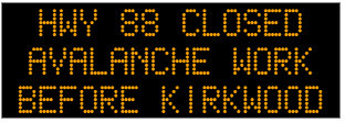
Is closed from 3.5 mi east of Silver Lake to Kirkwood /Carson Spur/ (Amador Co) – Due to snow – Motorists are advised to use an alternate route
Is closed from 2 mi east of Kirkwood to 5 mi west of Picketts Jct /Carson Pass/ (Alpine Co) – Due to avalanche control – Motorists are advised to use an alternate route
Chains are required on all vehicles except 4-wheel-drive vehicles with snow tires on all 4 wheels from Dew Drop (Amador Co) to 3.5 mi west of Woodfords (Alpine Co)
Please research chain control locations as caltrans is currently working to update chain control descriptions for consistency with internet mapping, like google maps & mapquest.
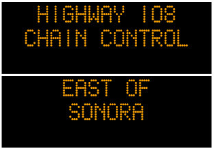
SR 108
[IN THE CENTRAL CALIFORNIA AREA & SIERRA NEVADA]
Is closed from 7.2 mi east of Strawberry to 5.3 mi west of the Jct of US 395 /Sonora Pass/ (Tuolumne,Mono Co) – For the winter – Motorists are advised to use an alternate route
Chains are required on all vehicles except 4-wheel-drive vehicles with snow tires on all 4 wheels from Camp Sunshine to 7.2 mi east of Strawberry (Tuolumne Co)
Chains or snow tires are required from 3.8 mi west of the Jct of US 395 to the Jct of US 395 (Mono Co)
Please research chain control locations as Caltrans is currently working to update chain control descriptions for consistency with internet mapping, like Google Maps & Mapquest
[YOSEMITE NAT’L PARK]
For Yosemite Nat’l Park road information call 209-372-0200
SR 120
[IN THE CENTRAL CALIFORNIA AREA & SIERRA NEVADA]
Is closed from Crane Flat to 3.5 mi west of the North Jct of US 395 /Tioga Pass/ (Tuolumne, Mono Co) – For the winter – Motorists are advised to use an alternate route
Is closed from 5.1 mi east of the South Jct of US 395 to 7.5 mi west of the Jct of US 6 (Mono Co) – For the winter – Motorists are advised to use an alternate route
Chains are required on all vehicles except 4-wheel-drive vehicles with snow tires on all 4 wheels from 8.5 mi east of Groveland (Tuolumne Co) to the Yosemite National Park Boundry
[YOSEMITE NAT’L PARK]
For Yosenite Nat’l Park road information call 209-372-0200
Chain Controls on Hwys 4, 88, 108 & 120. Hwy 88 Closed for Avalanche Work in Carson Spur Area. added by admin on
View all posts by admin →