

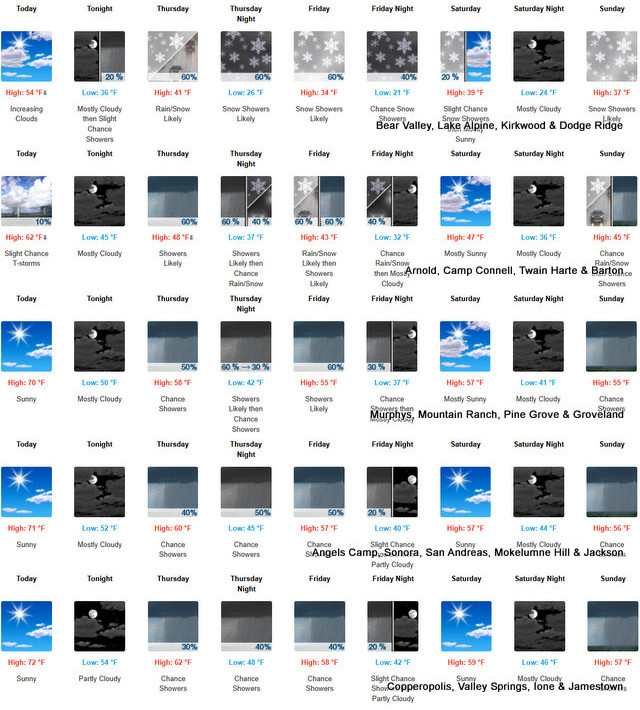
Arnold, CA…Detailed forecast for West Slope Northern Sierra Nevada from the NWS Sacramento. Today, Mostly sunny. Highs 50 to 65 higher elevations…59 to 71 lower elevations. Prevailing southeast winds up to 10 mph shifting to the southwest with gusts to around 40 mph in the afternoon.
ThePineTree.net Weather Sponsored By Fox Security

Tonight
Mostly cloudy with a slight chance of rain showers. Colder. Lows 31 to 45 higher elevations…39 to 51 lower elevations. Prevailing southwest winds up to 15 mph with gusts to around 40 mph…except southwest up to 30 mph over ridges.
Thursday
Mostly cloudy. At lower elevations, rain showers. At higher elevations, a chance of rain and snow showers in the morning, then rain and snow showers likely in the afternoon. Highs 36 to 51 higher elevations…43 to 57 lower elevations. No snow accumulation lower elevations…up to 1 inch higher elevations. Snow level 7500 feet. Prevailing southwest winds 5 to 15 mph with gusts to around 45 mph…except southwest 10 to 35 mph with gusts to around 55 mph over ridges.
Thursday Night
Rain and snow showers likely in the evening, then a chance of rain and snow showers after midnight. Colder. Lows 23 to 38 higher elevations…35 to 43 lower elevations. No snow accumulation lower elevations…up to 3 inches higher elevations. Snow level 6000 feet. Prevailing southwest winds up to 15 mph with gusts to around 45 mph…except southwest up to 30 mph with gusts to around 50 mph over ridges.
Friday
Rain and snow showers likely. Highs 30 to 45 higher elevations…39 to 53 lower elevations. No snow accumulation lower elevations…3 to 5 inches higher elevations. Snow level 5500 feet. Prevailing southwest winds up to 15 mph with gusts to around 30 mph…except southwest up to 25 mph over ridges.
Friday Night
Mostly cloudy with a chance of rain and snow showers. Colder. Lows 21 to 36.
Saturday
Partly cloudy with a slight chance of snow showers. Not as cool. Highs 38 to 53.
Saturday Night
Mostly cloudy. Lows 24 to 39.
Sunday
Mostly cloudy with a chance of rain and snow showers. Highs 36 to 51.
Sunday Night
Rain and snow showers likely. Light snow accumulations possible. Lows 28 to 43.
Monday Through Tuesday
Mostly cloudy with a chance of rain and snow showers. Highs 36 to 51. Lows 27 to 42.
Detailed forecast for Motherlode
Today
Mostly sunny. Highs 64 to 74. Light winds becoming southwest up to 10 mph in the afternoon.
Tonight
Mostly cloudy. A chance of rain showers after midnight. Lows 45 to 55. Prevailing south winds up to 10 mph.
Thursday
Mostly cloudy with a chance of rain showers. Highs 50 to 64. Prevailing south winds up to 10 mph.
Thursday Night
Mostly cloudy. Rain showers likely in the evening, then a chance of rain showers after midnight. Colder. Lows 40 to 48. Prevailing south winds up to 10 mph.
Friday
A chance of rain showers in the morning, then rain showers likely in the afternoon. Highs 46 to 56 higher elevations…53 to 61 lower elevations. Prevailing south winds up to 10 mph.
Friday Night
Mostly cloudy with a chance of rain showers. Lows 35 to 43.
Saturday
Mostly sunny. Highs 52 to 62.
Saturday Night
Mostly cloudy. Lows 38 to 46.
Sunday
Mostly cloudy with a chance of rain showers. Highs 49 to 59.
Sunday Night
Mostly cloudy with rain showers likely. Lows 41 to 49.
Monday Through Tuesday
Mostly cloudy with a chance of rain showers. Highs 49 to 63. Lows 39 to 49.
Winter Returns Tonight & Will Stick Around Through the Weekend! added by admin on
View all posts by admin →