

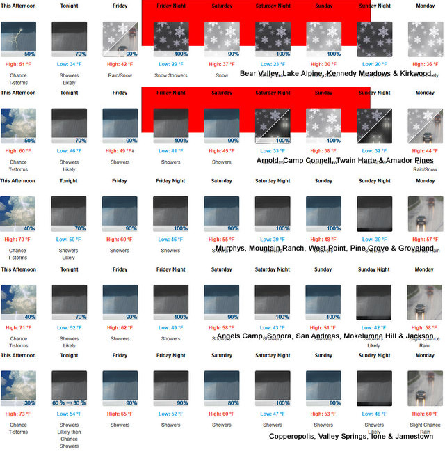
Arnold, CA…Heavy snow. Total snow accumulations 1 to 2 feet above 4500 feet, with up to 3 to 4 feet at the highest peaks. Minor snowfall accumulations of 2 to 4 inches down to 4000 feet. Winds could gust as high as 50 mph.
ThePineTree.net Weather Sponsored By Fox Security

Winter Storm Warning
URGENT – WINTER WEATHER MESSAGE
National Weather Service Sacramento CA
1146 AM PDT Thu Apr 9 2026
CAZ068-069-110015-
/O.UPG.KSTO.WS.A.0002.260411T0000Z-260413T0600Z/
/O.NEW.KSTO.WS.W.0003.260411T0000Z-260413T0600Z/
Western Plumas County/Lassen Park-West Slope Northern Sierra
Nevada-
Including the cities of Quincy, Blue Canyon, and Chester
1146 AM PDT Thu Apr 9 2026
…WINTER STORM WARNING IN EFFECT ABOVE 4500 FEET FROM 5 PM FRIDAY
TO 11 PM PDT SUNDAY…
* WHAT…Heavy snow. Total snow accumulations 1 to 2 feet above 4500
feet, with up to 3 to 4 feet at the highest peaks. Minor snowfall
accumulations of 2 to 4 inches down to 4000 feet. Winds could gust
as high as 50 mph.
* WHERE…West Slope Northern Sierra Nevada and Western Plumas
County/Lassen Park above 4500 feet.
* WHEN…From 5 PM Friday to 11 PM PDT Sunday.
* IMPACTS…Travel could be very difficult to impossible. The
hazardous conditions could impact the Friday evening commute and
weekend mountain travel.
* ADDITIONAL DETAILS…Snow levels generally remain above pass
levels through Friday afternoon, dropping to around 6000-7000 ft
Friday night-Saturday, then lowering to around 4000-5000 ft late
Saturday into Sunday. Heaviest snow rates and lowest snow levels
will be Saturday afternoon through Sunday.
PRECAUTIONARY/PREPAREDNESS ACTIONS…
Check the latest road conditions from Caltrans online at
quickmap.dot.ca.gov or dial 5 1 1.
&&
$$
For more information, visit us at www.weather.gov/sto/
KH
Winter Storm Warning from Friday Afternoon Through Sunday ~ Weather Sponsored by Fox Security added by admin on
View all posts by admin →