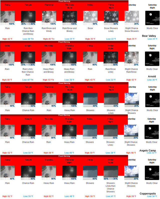
Arnold, CA…The rain and localized flood warnings are going to be with us for another few days. Rains will taper off after tomorrow and snow levels will drop back down along the West Slope Northern Sierra Nevada. Today At lower elevations, heavy rain. At higher elevations, rain and snow in the morning, then rain in the afternoon. Not as cool. Highs 38 to 50 higher elevations…48 to 56 lower elevations. No snow accumulation. Prevailing south winds 5 to 15 mph with gusts to around 35 mph…except southwest 15 to 30 mph over ridges.

Tonight
Rain in the evening, then a chance of rain after midnight. Breezy. Lows 33 to 48 higher elevations…45 to 51 lower elevations. Prevailing south winds 10 to 25 mph with gusts to around 45 mph…except southwest 25 to 40 mph over ridges.
Thursday
At lower elevations, a chance of rain in the morning, then heavy rain in the afternoon. At higher elevations, a chance of rain and snow in the morning, then heavy rain and snow in the afternoon. Windy. Highs 40 to 54 higher elevations…48 to 58 lower elevations. No snow accumulation lower elevations…up to 3 inches higher elevations. Snow level above 8000 feet. Prevailing south winds 20 to 35 mph with gusts to around 65 mph… Except south 35 to 60 mph with gusts to around 75 mph over ridges.
Thursday Night
Heavy rain and heavy snow. Windy, colder. Lows 25 to 39 higher elevations…37 to 45 lower elevations. No snow accumulation lower elevations…4 to 10 inches higher elevations. Snow level 7500 feet. Prevailing south winds 15 to 30 mph with gusts to around 50 mph decreasing to 5 to 15 mph with gusts to around 30 mph after midnight. Over ridges, prevailing south winds 30 to 45 mph becoming southwest 20 to 30 mph after midnight.
Friday
Rain and snow in the morning, then rain and snow showers likely in the afternoon. Highs 31 to 43 higher elevations…40 to 50 lower elevations. No snow accumulation lower elevations…3 to 5 inches higher elevations. Snow level 6500 feet. Prevailing south winds 5 to 15 mph…except southwest 15 to 30 mph over ridges.
Friday Night
Cloudy with a chance of rain and snow showers. Colder. Lows 21 to 36.
Saturday
Partly cloudy with a slight chance of rain and snow showers. Highs 33 to 48.
Saturday Night
Mostly clear. Lows 21 to 36.
Sunday And Sunday Night
Clear. Highs 40 to 55. Lows 23 to 38.
Monday Through Tuesday
Mostly clear. Highs 45 to 60. Lows 25 to 40.
Flood Warning
Flood Warning
National Weather Service Sacramento CA
926 AM PST TUE FEB 7 2017
CAC003-005-007-009-011-017-021-033-035-057-061-063-067-077-089-091-
095-099-101-103-109-113-115-111715-
/O.NEW.KSTO.FA.W.0009.170207T1726Z-170211T1715Z/
/00000.0.ER.000000T0000Z.000000T0000Z.000000T0000Z.OO/
Colusa CA-Yolo CA-Sutter CA-Solano CA-Plumas CA-Alpine CA-Placer CA-
Shasta CA-Lassen CA-Amador CA-Tuolumne CA-Sacramento CA-Lake CA-
Stanislaus CA-San Joaquin CA-El Dorado CA-Calaveras CA-Tehama CA-
Butte CA-Glenn CA-Sierra CA-Yuba CA-Nevada CA-
926 AM PST TUE FEB 7 2017
The National Weather Service in Sacramento has issued a
* Flood Warning for…
Colusa County in central California…
Yolo County in central California…
Sutter County in central California…
Solano County in central California…
Plumas County in northern California…
Alpine County in northern California…
Placer County in central California…
Shasta County in northern California…
Lassen County in northern California…
Amador County in northern California…
Tuolumne County in northern California…
Sacramento County in central California…
Lake County in central California…
Stanislaus County in central California…
San Joaquin County in central California…
El Dorado County in northern California…
Calaveras County in northern California…
Tehama County in northern California…
Butte County in northern California…
Glenn County in central California…
Sierra County in northern California…
Yuba County in central California…
Nevada County in northern California…
* Until 915 AM PST Saturday
* Widespread flooding is already occurring across interior Northern
California. Periods of heavy rain will continue this week and
flooding will persist even after the rain subsides. Expect
flooding threats to linger into Saturday. This warning is an
expansion in time and area from the previous warning.
* Some locations that will experience flooding include…
Sacramento, Stockton, Modesto, Elk Grove, Roseville, Fairfield,
Vacaville, Redding, Chico, Citrus Heights, Tracy, Folsom, Turlock,
Davis, Rocklin, Woodland, Ceres, Paradise, Galt and Oakdale.
PRECAUTIONARY/PREPAREDNESS ACTIONS…
Turn around, don`t drown when encountering flooded roads. Most flood
deaths occur in vehicles.
&&
LAT…LON 3776 11988 3780 12018 3715 12121 3725 12146
3810 12157 3815 12240 3832 12206 3884 12229
3867 12262 3907 12309 3950 12306 3955 12288
4033 12307 4058 12269 4117 12246 4118 12250
4118 12133 4059 12132 3835 11963
$$
JBB/EK
Wind Advisory
URGENT – WEATHER MESSAGE
National Weather Service Sacramento CA
315 AM PST Wed Feb 8 2017
CAZ016>018-064-067-069-090000-
/O.NEW.KSTO.WI.Y.0016.170209T1200Z-170210T0000Z/
Central Sacramento Valley-Southern Sacramento Valley-
Carquinez Strait and Delta-Clear Lake/Southern Lake County-
Motherlode-West Slope Northern Sierra Nevada-
Including the cities of Chico, Oroville, Marysville/Yuba City,
Sacramento, Fairfield/Suisun, Lakeport, Grass Valley, Jackson,
and Blue Canyon
315 AM PST Wed Feb 8 2017
…WIND ADVISORY IN EFFECT FROM 4 AM TO 4 PM PST THURSDAY…
The National Weather Service in Sacramento has issued a Wind
Advisory, which is in effect from 4 AM to 4 PM PST Thursday.
* TIMING…Late tonight through Thursday afternoon.
* WINDS…SOUTH 20 TO 30 MPH WITH GUSTS 40 TO 50 MPH IN THE VALLEY
AND FOOTHILLS. LOCAL GUSTS 50 TO 70 MPH ACROSS THE HIGHER
ELEVATIONS OF THE NORTHERN SIERRA.
* IMPACTS…POSSIBLE DOWNED TREES AND POWER OUTAGES ALONG WITH
DIFFICULT DRIVING CONDITIONS, ESPECIALLY FOR HIGH PROFILE
VEHICLES.
PRECAUTIONARY/PREPAREDNESS ACTIONS…
A Wind Advisory means that wind gusts of 40 mph or greater are
expected. Winds this strong can make driving difficult, especially
for small cars and high profile vehicles. Use extra caution.
&&
Interact with us via social media
www.facebook.com/nws.sacramento
www.twitter.com/nwssacramento
$$


