

Angels Camp, CA…National Weather Service Sacramento’s detailed forecast for Motherlode. Rest Of Today Mostly sunny. Highs 98 to 108. Prevailing east winds up to 10 mph shifting to the southwest in the afternoon. Tonight Mostly clear. Lows 66 to 76. Prevailing southwest winds up to 10 mph shifting to the east after midnight.
Wednesday Mostly sunny. Highs 91 to 103. Prevailing east winds up to 10 mph shifting to the southwest in the afternoon.
Wednesday Night Clear. Lows 63 to 73. Prevailing southwest winds up to 10 mph in the evening becoming light.
Thursday Sunny, warmer. Highs 96 to 108. Light winds becoming southwest up to 10 mph in the afternoon.
Thursday Night Clear. Lows 67 to 79.
Friday Sunny. Highs 99 to 111.
Friday Night Through Saturday Night Clear. Lows 69 to 79. Highs 99 to 111.
Sunday Through Labor Day
Excessive Heat Watch
URGENT – WEATHER MESSAGE
National Weather Service Sacramento CA
330 AM PDT Tue Aug 29 2017
…Very Hot Weather Expected into Next Week…
.Strong high pressure will maintain very hot weather across the
region into next week. Temperatures won`t be quite as hot today
and Wednesday, but excessive heat will likely return beginning
Thursday and continue through the Labor Day weekend with an
increasing risk for heat-related illnesses for people exposed to
the hot weather.
CAZ013>019-063-064-066>069-300000-
/O.NEW.KSTO.EH.A.0005.170831T1900Z-170905T0300Z/
Shasta Lake Area / Northern Shasta County-
Burney Basin / Eastern Shasta County-Northern Sacramento Valley-
Central Sacramento Valley-Southern Sacramento Valley-
Carquinez Strait and Delta-Northern San Joaquin Valley-
Mountains Southwestern Shasta County to Northern Lake County-
Clear Lake/Southern Lake County-
Northeast Foothills/Sacramento Valley-Motherlode-
Western Plumas County/Lassen Park-
West Slope Northern Sierra Nevada-
Including the cities of Shasta Dam, Burney, Redding, Red Bluff,
Chico, Oroville, Marysville/Yuba City, Sacramento,
Fairfield/Suisun, Stockton, Modesto, Alder Springs, Lakeport,
Paradise, Grass Valley, Jackson, Chester, Quincy, and Blue Canyon
330 AM PDT Tue Aug 29 2017
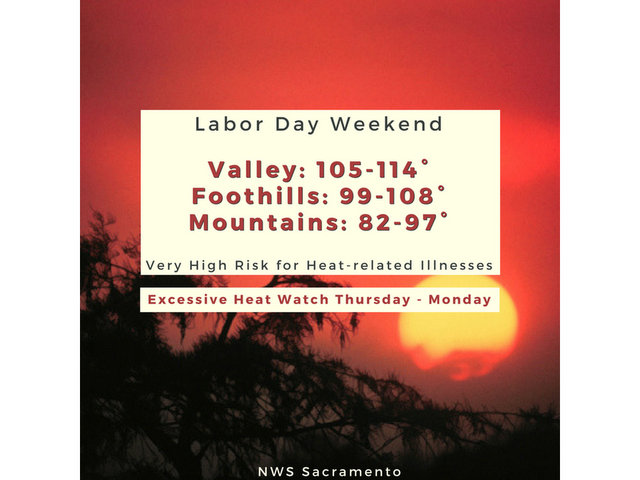
…EXCESSIVE HEAT WATCH IN EFFECT FROM THURSDAY AFTERNOON THROUGH
MONDAY EVENING…
The National Weather Service in Sacramento has issued an
Excessive Heat Watch, which is in effect from Thursday afternoon
through Monday evening.
* TEMPERATURE…Daytime highs will range from 110 to 115 across
much of the Central Valley with overnight lows only in the 70s
to lower 80s in the Central Valley and foothill thermal belts.
The hottest temperatures are expected Friday and Saturday, then
not quite as hot Sunday and Labor Day.
* IMPACTS…Potential for HIGH risk of heat related illness,
especially for sensitive groups: elderly, children, sick people
and pets and livestock.
* ADDITIONAL IMPACTS…Plan outdoor activities accordingly! Try to
schedule holiday weekend activities in the morning or evening
when temperatures will be cooler, and with less exposure to
direct sunlight.
PRECAUTIONARY/PREPAREDNESS ACTIONS…
An Excessive Heat Watch means that a prolonged period of hot
temperatures is expected. This may create a DANGEROUS SITUATION
in which heat illnesses are possible. Drink plenty of fluids, stay
in an air-conditioned room, stay out of the sun, and check up on
relatives and neighbors.
&&
Interact with us via social media
www.facebook.com/nws.sacramento
www.twitter.com/nwssacramento
$$
Excessive Heat Warnings For Labor Day Weekend! Highs added by admin on
View all posts by admin →