

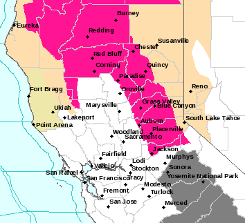
Arnold, CA….Red Flag & Air Quality Warnings Continue for Northern California the full list is enclosed…
Red Flag Warning
URGENT – FIRE WEATHER MESSAGE
National Weather Service Sacramento CA
820 AM PDT Wed Sep 6 2017
…ABUNDANT LIGHTNING POSSIBLE THIS AFTERNOON THROUGH THURSDAY
EVENING…
A robust upper level weather system off the California coast will
move inland this afternoon into Thursday, and bring the potential
for scattered to numerous thunderstorms across the region.
Abundant lightning strikes and gusty, erratic winds may accompany
these thunderstorms. The combination of frequent lightning and
very dry fuels may cause critical fire weather conditions for the
mountains and foothills. Some thunderstorms may drift into the
northern Sacramento valley and bring and increase for fire starts.
CAZ213>215-263-266>269-279-070400-
/O.UPG.KSTO.FW.A.0006.170906T2100Z-170908T0600Z/
/O.NEW.KSTO.FW.W.0008.170906T2100Z-170908T0600Z/
Eastern Portion of Shasta/Trinity NF-
Burney Basin and Northeast Plateau in Shasta County Including
Northwest Lassen NF north of Lassen NP-
Northern Sacramento Valley to Southern Tehama County Line Below
1000 Ft-Southeast Edge Shasta-
Trinity NF and Western Portions of Tehama-Glenn Unit-
Northern Sierra Foothills from 1000 to 3000 Ft. Includes portions
of Shasta-Trinity and Butte Units-
Northern Motherlode From 1000 to 3000 Ft. Includes portions of
Nevada-Yuba-Placer-Amador and ElDorado Units-
Northern Sierra Including Lassen NP and Plumas and Lassen NF/S
West of the Sierra Crest (West of Evans Peak-Grizzly Peak-
Beckworth Peak)-
Northern Sierra Including the Tahoe and ElDorado NF/S West of the
Sierra Crest-Eastern Mendocino NF-
820 AM PDT Wed Sep 6 2017
…RED FLAG WARNING IN EFFECT FROM 2 PM THIS AFTERNOON TO 11 PM
PDT THURSDAY FOR ABUNDANT LIGHTNING FOR FIRE WEATHER ZONES 213,
214, 215, 263, 266, 267, 268, 269, AND 279…
The National Weather Service in Sacramento has issued a Red Flag
Warning for abundant lightning, which is in effect from 2 PM this
afternoon to 11 PM PDT Thursday. The Fire Weather Watch is no
longer in effect.
* THUNDERSTORMS…Scattered to numerous thunderstorms will be
possible with some wetting rain, especially for the mountains.
Lightning may strike outside of rain cores.
* OUTFLOW WINDS…Gusty, erratic winds are expected near any
thunderstorms that develop, perhaps to as strong as 40 mph.
* TIMING…this afternoon through Thursday evening. The most
widespread thunderstorms are expected late Wednesday night
through Thursday afternoon.
* IMPACTS…any fires that develop from lightning strikes will
likely spread rapidly.
PRECAUTIONARY/PREPAREDNESS ACTIONS…
A Red Flag Warning for abundant lightning means that frequent
lightning may increase fire starts for the warned area. A
combination of fire starts from lightning and gusty strong
outflow winds in thunderstorms can contribute to extreme fire
behavior.
&&
Interact with us via social media
www.facebook.com/nws.sacramento
www.twitter.com/nwssacramento
$$
Urgent – Fire Weather Message
National Weather Service Eureka CA
824 AM PDT Wed Sep 6 2017
…SCATTERED TO NUMEROUS THUNDERSTORMS WITH ABUNDANT LIGHTNING
POSSIBLE THURSDAY MORNING THROUGH THURSDAY EVENING…
.Scattered to potentially numerous thunderstorms are expected to
develop across a broad area of Northwest California on Thursday.
Storms may form as early as Thursday morning and last through
Thursday evening, and may feature abundant cloud-to-ground
lightning strikes. While storms will likely produce wetting
rains, some lightning will strike outside of rain cores and ignite
very dry fuels. Some storms will become strong with gusty,
erratic wind gusts and hail. In addition, isolated thunderstorm
activity will be possible Wednesday afternoon and evening,
although not as numerous.
CAZ203-204-211-283-062330-
/O.CON.KEKA.FW.W.0009.170907T1200Z-170908T0600Z/
Upper Smith-Lower Middle Klamath-Hoopa-Trinity-
824 AM PDT Wed Sep 6 2017
…RED FLAG WARNING REMAINS IN EFFECT FROM 5 AM TO 11 PM PDT
THURSDAY…
* AFFECTED AREA…Fire weather zone 203, 204, 211, and 283.
* THUNDERSTORMS…Scattered to numerous thunderstorms with some
wetting rain. Strongest storms may produce frequent
lightning, including strikes outside of rain cores. Storms
are expected to move quickly from SE to NW.
* OUTFLOW WINDS…Erratic gusty winds are expected near any
storms that develop, gusting over 40 mph with the stronger
cells.
PRECAUTIONARY/PREPAREDNESS ACTIONS…
A Red Flag Warning means that critical fire weather conditions
are either occurring now, or will shortly.
$$
URGENT – FIRE WEATHER MESSAGE
National Weather Service Medford OR
711 AM PDT Wed Sep 6 2017
…Abundant lightning expected today into Thursday evening for
Northern California and southern Oregon…
CAZ281-282-284-285-ORZ615>617-620>625-071200-
/O.CON.KMFR.FW.W.0046.170906T1800Z-170908T0600Z/
Central Siskiyou County Including Shasta Valley-Shasta-
Trinity National Forest in Siskiyou County-
Siskiyou County from the Cascade Mountains East and South to Mt
Shasta-Modoc County Except for the Surprise Valley-
South Central Oregon Coast-Umpqua Basin-Umpqua National Forest-
Western Rogue Basin including the Illinois Valley-
Siskiyou Mountains-Eastern Rogue Valley-Southern Oregon Cascades-
Klamath Basin and the Fremont-Winema National Forest-
South Central Oregon Desert including the BLM Land in Eastern
Lake and Western Harney Counties-
711 AM PDT Wed Sep 6 2017
…RED FLAG WARNING IN EFFECT FROM 11 AM TODAY TO 11 PM PDT
THURSDAY FOR ABUNDANT LIGHTNING ON DRY FUELS FOR FIRE WEATHER
ZONES 281, 282, 284, AND 285 IN NORTHERN CALIFORNIA AND FIRE
WEATHER ZONES 615, 616, 617, 620, 621, 622, 623, 624, AND 625 IN
OREGON…
* Thunderstorms: The possibility for lightning will increase this
afternoon and evening. Tonight into Thursday evening another
low pressure impulse is expected to move through with another
round of scattered lightning that could extend westward to the
coast. Thunderstorms on Thursday could produce locally heavy
rainfall.
* Affected area: Fire Weather Zones 281, 282, 284, and 285 in
northern California, and fire weather zones 615, 616, 617,
620, 621, 622, 623, 624, and 625 in Oregon.
* Wind: Gusty and erratic winds of 30 to 40 mph are possible
from stronger thunderstorms.
* View the hazard area in detail at
http://www.wrh.noaa.gov/map/?wfo=mfr
Precautionary/preparedness actions…
A Red Flag Warning means that critical fire weather conditions
are either occurring now, or will shortly. Lightning strikes with
little or no precipitation combined with dry fuels create
conditions where many fire starts may occur in a short period of
time.
&&
$$
Visit us at www.weather.gov/medford
URGENT – FIRE WEATHER MESSAGE
National Weather Service Medford OR
711 AM PDT Wed Sep 6 2017
…Abundant lightning expected today into Thursday evening for
Northern California and southern Oregon…
CAZ280-ORZ618-619-071200-
/O.CON.KMFR.FW.W.0046.000000T0000Z-170908T0600Z/
Western Klamath National Forest-Southern Oregon Coast-
Western Rogue River-Siskiyou National Forest-
711 AM PDT Wed Sep 6 2017
…RED FLAG WARNING REMAINS IN EFFECT UNTIL 11 PM PDT THURSDAY
FOR ABUNDANT LIGHTNING ON DRY FUELS FOR FIRE WEATHER ZONE 280 IN
CALIFORNIA AND FIRE WEATHER ZONES 618 AND 619 IN OREGON…
* Thunderstorms: This afternoon and evening the possibility of
lightning increases inland into fire weather zones 619 and 280,
but tonight into Thursday another low pressure impulse is
expected to move through with another round of scattered
lightning that could extend westward to the coast.
* Affected area: Fire weather zone 280 in northern California,
and fire weather zones 618 and 619 is southwestern Oregon.
* Wind: Gusty and erratic winds of 30 mph are possible from
stronger thunderstorms into Thursday morning. Storms today and
Thursday afternoon and evening could bring localized wind gusts
as high as 40 mph.
* View the hazard area in detail at
http://www.wrh.noaa.gov/map/?wfo=mfr
Precautionary/preparedness actions…
A Red Flag Warning means that critical fire weather conditions
are either occurring now, or will shortly. Scattered
thunderstorms combined with dry fuels create conditions where
many fire starts may occur in a short period of time.
&&
$$
Red Flag & Air Quality Warnings Continue for Northern California added by admin on
View all posts by admin →