


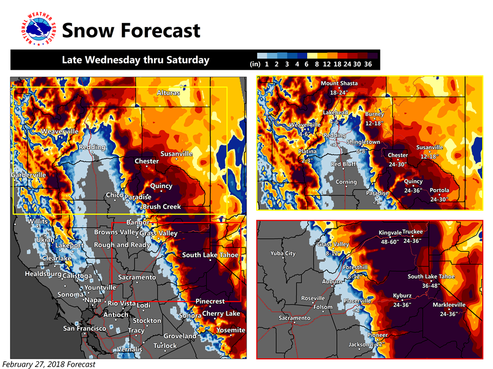
Arnold, CA….A series of cold winter storms will bring periods of heavy snow and gusty winds to the foothills and mountains of interior NorCal later this week. Snow may begin as early as Wednesday afternoon and continue through the weekend. Several feet of snowfall accumulation is expected in the mountains with up to a foot possible across some foothill locations. Portions of the northern Sacramento Valley, including Redding, may see accumulating snow Thursday night and Friday. Any planning travel across the foothills or mountains later this week should stay in touch with the latest forecasts.
One product issued by NWS for: 11 Miles WSW Ebbets Pass CA
Share |
Winter Storm Watch
URGENT – WINTER WEATHER MESSAGE
National Weather Service Sacramento CA
300 AM PST Tue Feb 27 2018
…Heavy Snow Later this Week…
.A series of cold winter storms will bring periods of heavy snow
and gusty winds to the foothills and mountains of interior NorCal
later this week. Snow may begin as early as Wednesday afternoon
and continue through the weekend. Several feet of snowfall
accumulation is expected in the mountains with up to a foot
possible across some foothill locations. Portions of the northern
Sacramento Valley, including Redding, may see accumulating snow
Thursday night and Friday. Any planning travel across the
foothills or mountains later this week should stay in touch with
the latest forecasts.
CAZ013-014-063-064-066>069-280000-
/O.NEW.KSTO.WS.A.0006.180301T0300Z-180303T1800Z/
Shasta Lake Area / Northern Shasta County-
Burney Basin / Eastern Shasta County-
Mountains Southwestern Shasta County to Northern Lake County-
Clear Lake/Southern Lake County-
Northeast Foothills/Sacramento Valley-Motherlode-
Western Plumas County/Lassen Park-
West Slope Northern Sierra Nevada-
Including the cities of Burney and Grass Valley
300 AM PST Tue Feb 27 2018
…WINTER STORM WATCH IN EFFECT FROM WEDNESDAY EVENING THROUGH
SATURDAY MORNING ABOVE 2000 FEET…
* WHAT…Heavy snow possible. Travel will be very difficult. Total
snow accumulations of 6 to 12 inches above 2000 feet, 2 to 4
feet above 3500 feet with localized amounts greater than 5 feet
possible across the highest terrain.
* WHERE…Foothills and mountains of northern California.
* WHEN…From Wednesday evening through Saturday morning.
* ADDITIONAL DETAILS…Significant reductions in visibility are
possible along with areas of blowing snow.
PRECAUTIONARY/PREPAREDNESS ACTIONS…
A Winter Storm Watch means there is potential for significant
snow accumulations that may impact travel. Continue to monitor
the latest forecasts.
$$
Heavy Snow Later this Week…As a “Miracle March” Begins? added by admin on
View all posts by admin →