


Arnold, CA…The next winter storm will bring periods of heavy snow and strong wind to the mountains of interior Northern California. Heaviest snow is expected Thursday afternoon through Friday afternoon, with periods of whiteout conditions likely. An additional 1 to 4 feet of snow accumulation is possible above 3000 feet with 3 to 5 feet at pass levels through Friday night. Snow levels will remain around 2000 to 3000 feet across the northern mountains, and 3000 to 4000 feet across the west slopes of the Northern Sierra.
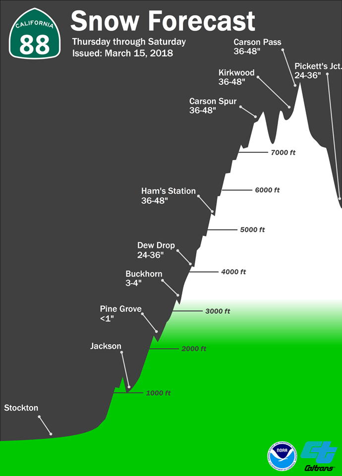
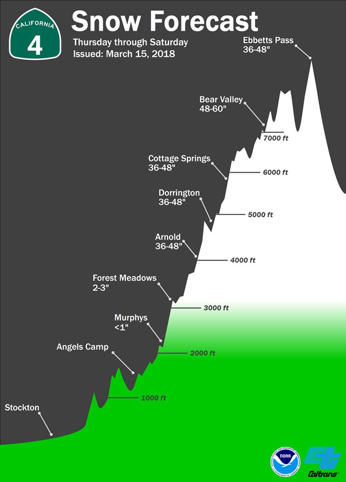
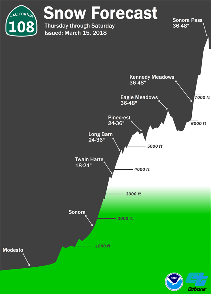
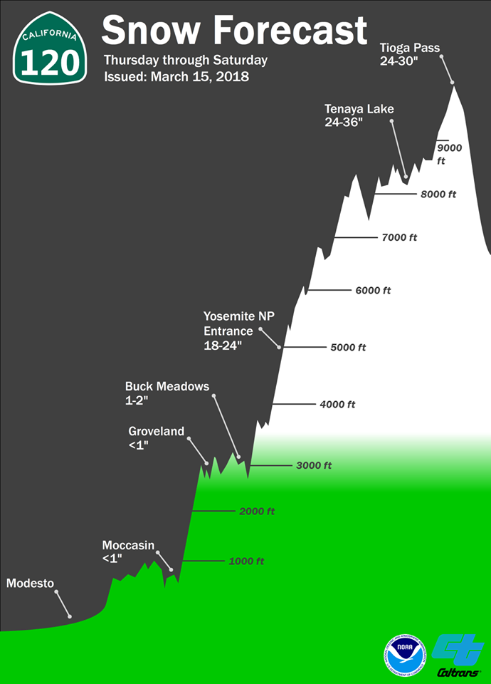
Above Are Some Great Graphics From the National Weather Service on Snow Totals. Click for Larger Images
Impacts to travel will likely be severe with periods of near whiteout conditions, travel delays, chain controls, and possible road closures. Plan travel accordingly. Full Details are below…
Winter Storm Warning
URGENT – WINTER WEATHER MESSAGE
National Weather Service Sacramento CA
336 AM PDT Thu Mar 15 2018
…Periods of Heavy Snow and Strong Wind through Friday night…
.The next winter storm will bring periods of heavy snow and
strong wind to the mountains of interior Northern California.
Heaviest snow is expected Thursday afternoon through Friday
afternoon, with periods of whiteout conditions likely. An
additional 1 to 4 feet of snow accumulation is possible above
3000 feet with 3 to 5 feet at pass levels through Friday night.
Snow levels will remain around 2000 to 3000 feet across the
northern mountains, and 3000 to 4000 feet across the west slopes
of the Northern Sierra.
Impacts to travel will likely be severe with periods of near
whiteout conditions, travel delays, chain controls, and possible
road closures. Plan travel accordingly.
CAZ069-160100-
/O.CON.KSTO.WS.W.0006.180316T0000Z-180317T1200Z/
West Slope Northern Sierra Nevada-
336 AM PDT Thu Mar 15 2018
…WINTER STORM WARNING REMAINS IN EFFECT FROM 5 PM THIS
AFTERNOON TO 5 AM PDT SATURDAY ABOVE 3500 FEET…
* WHAT…Heavy snow expected. Travel will be very difficult to
nearly impossible. Total snow accumulations of 1 to 4 feet, with
localized amounts up to 5 feet, are expected.
* WHERE…West Slope Northern Sierra Nevada.
* WHEN…5 PM today to 5 AM Saturday.
* ADDITIONAL DETAILS…Be prepared for significant reductions in
visibility at times.
PRECAUTIONARY/PREPAREDNESS ACTIONS…
A Winter Storm Warning for snow means there will be snow covered
roads and limited visibilities. Travel is not recommended while
the warning is in effect. If you must travel, keep an extra
flashlight, food and water in your vehicle in case of an
emergency.The latest road conditions for the state you are
calling from can be obtained by calling 5 1 1.
$$
Winter Storm Warning with Periods of Heavy Snow & Winds Through Friday Night added by admin on
View all posts by admin →