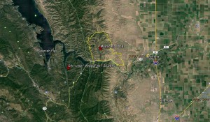
Lake Berryessa Ca. CalFire and multiple Agencies are on the scene of a 700 ac plus Vegetation Fire on the South East end of Lake Berryessa California. We bring you this story because some of you might have family or friends in the region of this incident. Last year the Monticello Fire you see in the Yellow Lined Perimeter burned 6,488 acres before it was finally contained.
Update 7 23 2015 4:09pm 6.9k might as well say 7k and 15% contained,
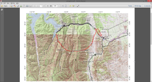
Update 7 3 2015 2:03pm rough perimeter map:
Update 7 23 2015 1:10pm 6,700 Aces 5% Contained
Update 7 23 22015 7:42am Per CalFire: 6k Acres 5% Contained. As soon as we get a Fire Perimeter Map we will post one.
Updated: 7 22 2015 9:36pm 4k acres per the IC We will try to keep you updated as news becomes available. The links provided below will also help you stay updated.
Information about this incident can be found on the main CalFire web site here: #WraggFire
You can listen online to this fire incident here: Broadcastify LNU
Another venue for information on this incident can be found here: CA LNU WRAGG Wildlandfire.com
As of this post more Hand Crews and Strike Teams are being called for on this incident.
Here is a another view in Google Maps: #WraggFire Google Maps
Google Earth Lat and Lon are: 38°29’59.54″N – 122° 9’19.01″W
We here at The Pine Tree send our prayers with all Fire Crews, LEO’s, EMS, Animal Rescue Groups, Evacuation Centers on the ground and all resource agencies helping in evacuations and more plus with those trying to get out of the way of this fire.


