


Arnold, CA…A Flash Flood Warning has been issued for portions of Tuolumne & Calaveras Counties until 1:45pm. A line of thunderstorms has produced very heavy rain. Flooding & mudslides have been reported with this storm. Never drive through flooded roads!
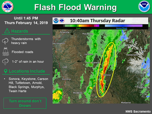
* Some locations that will experience flooding include…
Sonora, Calaveras Big Trees SP, Keystone, Carson Hill, Tuttletown,
Vallecito, Black Springs, Jupiter, Springfield, Chinese Camp,
Dorrington, Avery, Forest Meadows, Mountain Ranch, Rail Road Flat,
Tuolumne City, Murphys, Phoenix Lake-Cedar, Mi-
Wuk Village and Twain Harte.
Additional rainfall amounts of 1 to 2 inches are possible in the
warned area.
PRECAUTIONARY/PREPAREDNESS ACTIONS…
Turn around, don`t drown when encountering flooded roads. Most flood
deaths occur in vehicles.
Move to higher ground now. Act quickly to protect your life.
&&
LAT…LON 3774 12050 3804 12053 3840 12039 3848 12025
3847 12011 3807 12017 3781 12026 3767 12042
$$
PCH
Flash Flood Warning
Flash Flood Statement
National Weather Service Sacramento CA
1023 AM PST THU FEB 14 2019
CAC005-009-017-142015-
/O.CON.KSTO.FF.W.0003.000000T0000Z-190214T2015Z/
/00000.0.ER.000000T0000Z.000000T0000Z.000000T0000Z.OO/
El Dorado CA-Calaveras CA-Amador CA-
1023 AM PST THU FEB 14 2019
…THE FLASH FLOOD WARNING REMAINS IN EFFECT UNTIL 1215 PM PST FOR
SOUTH CENTRAL EL DORADO…CENTRAL CALAVERAS AND CENTRAL AMADOR
COUNTIES…
At 1019 AM PST, Doppler radar indicated thunderstorms producing
heavy rain across portions of the warned area. Up to two and a half
inches of rain have already fallen. Mud slides have been reported
and portions of highway 26 and 49 are closed.
Some locations that will experience flooding include…
San Andreas, Rail Road Flat, Glencoe, Mountain Ranch, Pioneer, Cooks
Station, Lily Gap, Hodson, Copperopolis, Copper Cove Village and
Angels Camp.
Additional rainfall amounts of 1 to 3 are possible in the warned
area.
PRECAUTIONARY/PREPAREDNESS ACTIONS…
Turn around, don`t drown when encountering flooded roads. Most flood
deaths occur in vehicles.
Move to higher ground now. Act quickly to protect your life.
&&
LAT…LON 3873 12028 3794 12061 3798 12072 3871 12050
$$
PCH
Special Weather Statement
Special Weather Statement…Corrected
National Weather Service Sacramento CA
1026 AM PST THU FEB 14 2019
CAZ019-067-069-141915-
Northern San Joaquin Valley-Motherlode-West Slope Northern Sierra
Nevada-
1026 AM PST THU FEB 14 2019
…A LINE OF STRONG THUNDERSTORMS WILL AFFECT SOUTHWESTERN
TUOLUMNE…NORTHEASTERN STANISLAUS…SOUTH CENTRAL EL DORADO…
CENTRAL CALAVERAS AND CENTRAL AMADOR COUNTIES…
At 1014 AM PST, radar indicated strong thunderstorms were located
along a line extending from near Cooks Station to near Keystone.
Movement was northeast at 10 mph.
Torrential rainfall is occurring with these storms, along with
reports of flooding and mud slides. Do not drive your vehicle
through flooded roadways.
Frequent cloud to ground lightning is occurring with this storm.
Lightning can strike 10 miles away from a thunderstorm. Seek a safe
shelter inside a building or vehicle.
Winds in excess of 40 mph and pea size hail are possible with these
storms.
A Flash Flood Warning is in effect for portions of El Dorado,
Calaveras, and Amador counties due to some of these storms.
Locations impacted include…
Sonora, Tuttletown, Vallecito, Rail Road Flat, Cooks Station, Lily
Gap, Keystone, Mountain Ranch, Springfield, Angels City, Chinese
Camp, Avery, Forest Meadows, Carson Hill, Angels Camp, Arnold,
Columbia, Jamestown, East Sonora and Murphys.
LAT…LON 3866 12026 3777 12035 3777 12057 3855 12056
TIME…MOT…LOC 1814Z 234DEG 10KT 3852 12054 3778 12054
$$
PCH
Winter Storm Warning
URGENT – WINTER WEATHER MESSAGE
National Weather Service Sacramento CA
300 AM PST Thu Feb 14 2019
CAZ068-069-150000-
/O.CON.KSTO.WS.W.0008.000000T0000Z-190216T1200Z/
Western Plumas County/Lassen Park-
West Slope Northern Sierra Nevada-
300 AM PST Thu Feb 14 2019
…WINTER STORM WARNING REMAINS IN EFFECT UNTIL 4 AM PST
SATURDAY…
* WHAT…Moderate to heavy rain this morning with heavy snow
accumulation limited to the higher peaks. Heavy snow returns to
the pass levels around midday with snow levels lowering below
3500 feet tonight. Travel will be very difficult to impossible.
Damage to trees and power lines is possible. Additional snow
accumulations of 3 to 5 feet above 3500 feet, with local
accumulations of 7 to 8 feet, are expected.
* WHERE…Western Plumas County/Lassen Park and West Slope
Northern Sierra Nevada.
* WHEN…Until 4 AM Saturday.
* ADDITIONAL DETAILS…Be prepared for significant reductions in
visibility at times.
PRECAUTIONARY/PREPAREDNESS ACTIONS…
A Winter Storm Warning for snow means there will be snow covered
roads and limited visibilities. Travel is not recommended while
the warning is in effect. If you must travel, keep an extra
flashlight, food and water in your vehicle in case of an
emergency.The latest road conditions for the state you are
calling from can be obtained by calling 5 1 1.
$$
Flood Watch
Flood Watch
National Weather Service Sacramento CA
329 PM PST Wed Feb 13 2019
…Heavy Rain and Snow Melt Increase Flood Threat over Northern
California…
.Heavy rainfall Tuesday night and Wednesday has caused areas
of flooding over northern California and more rain is on the way
Wednesday night and Thursday.
CAZ013-015>019-063-064-066>069-150400-
/O.EXT.KSTO.FA.A.0002.000000T0000Z-190215T0400Z/
/00000.0.RS.000000T0000Z.000000T0000Z.000000T0000Z.OO/
Shasta Lake Area / Northern Shasta County-
Northern Sacramento Valley-Central Sacramento Valley-
Southern Sacramento Valley-Carquinez Strait and Delta-
Northern San Joaquin Valley-
Mountains Southwestern Shasta County to Northern Lake County-
Clear Lake/Southern Lake County-
Northeast Foothills/Sacramento Valley-Motherlode-
Western Plumas County/Lassen Park-
West Slope Northern Sierra Nevada-
329 PM PST Wed Feb 13 2019
…FLOOD WATCH NOW IN EFFECT THROUGH THURSDAY EVENING…
…THIS FLOOD WATCH ALSO INCLUDES RECENT BURN SCAR AREAS…
The Flood Watch is now in effect for
* A large portion of northern California…including the
following areas…Carquinez Strait and Delta…Central
Sacramento Valley…Clear Lake/Southern Lake
County…Motherlode… Mountains Southwestern Shasta County to
Northern Lake County… Northeast Foothills/Sacramento
Valley…Northern Sacramento Valley…Northern San Joaquin
Valley…Shasta Lake Area / Northern Shasta County…Southern
Sacramento Valley…West Slope Northern Sierra Nevada and
Western Plumas County/Lassen Park.
* Through Thursday evening
* Periods of moderate to heavy rain can be expected through
Thursday, in addition to the 1 to 3 inches of rain that fell
Tuesday night through Wednesday afternoon. Additional rainfall
of 2 to 8 inches is forecast over the West Slope Sierra Nevada
and 2 to 4 inches over the Coastal Range and Shasta County
mountains Wednesday night through Thursday evening. In the
Central Valley, additional rainfall near 2 inches is forecast
over the Northern Sacramento Valley to less than one half inch
in the northern San Joaquin Valley.
* Rising snow levels will contribute some additional runoff as
snow melts across the foothills and lower mountain elevations.
* Recent burn scar areas may also experience minor mud, rock and
debris flows, especially if thunderstorms develop in the burn
scar areas on Thursday. This includes the Carr, Hirz, Delta
fire burn areas in Shasta County, the Mendocino Complex burn
area in Lake, Glenn, Colusa Counties, and the Camp Fire burn
area in Butte County in Northern California.
PRECAUTIONARY/PREPAREDNESS ACTIONS…
A Flood Watch means there is a potential for flooding based on
current forecasts.
You should monitor later forecasts and be alert for possible
Flood Warnings. Those living in areas prone to flooding should be
prepared to take action should flooding develop.
&&
$$
Flash Flood Warning for Areas of Tuolumne & Calaveras Counties Until 1:45pm added by admin on
View all posts by admin →