

Rodden Ca. CalFire out of the Tuolumne/Calaveras Unit along with multiple agencies from the Stanislaus County area and other Valley Districts are on scene of 2 Vegetation Fires 5 miles East of Oakdale California. Aircraft have been released from the scene at this time and both fires are in heavy mop up operations. If you do not need to go into the area please stay away so fire crews can work both incidents. If you see a Drone(s) over either incident please call the Stanislaus County Sheriff immediately. At last report 25 acres had been burned with both fires now under control. There could be upwards of a 5-6 hr commit time for the units on scene.
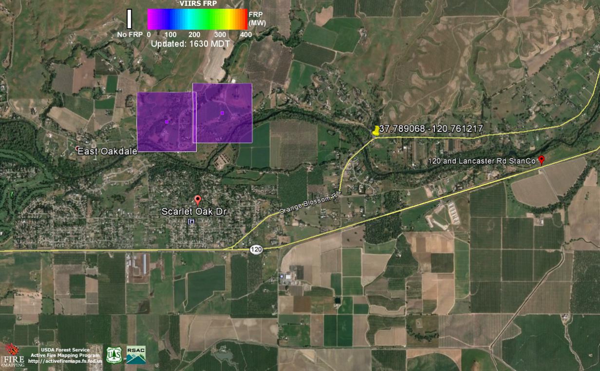
Above is a image of the effected area. The Purple Squares are Satellite Fire Detection Centroids as seen in what is called VIIRS FRP though a Google Earth KML plug in. FRP means Fire Reactive Power and per the small color scale at the top of the image Left to Right is Cold to Hot. USDA VIIRS FRP
The CHP LIVE CAD Web Log:
Incident: 00448 Type: Report of Fire Location: Rodden Rd / Orange Blossom Rd Loc Desc: Lat/Lon: 37.789068 -120.761217
Detail Information
1:15 PM 8 [25] B48-020 JNO MCCLOUD WITH A POWER LINE IN THE RD
1:13 PM 7 [24] B48-020 AT MCCLOUD NOW CAN SEE SMOKE
1:12 PM 6 [22] 1039 FIRE
1:08 PM 5 [11] UPDATED FIRE
1:07 PM 4 [8] [Appended, 13:08:12] [1] GRASS FIRE
1:07 PM 3 [2] FIRE ENRT
1:07 PM 2 [6] [2] TOT STAN CO FIRE
1:07 PM 1 [5] [1] GRASS FIRE
Unit Information
1:09 PM 6 Unit Assigned
1:09 PM 5 Unit Enroute
1:13 PM 4 Unit At Scene
1:09 PM 3 Unit Assigned
1:09 PM 2 Unit Enroute
1:15 PM 1 Unit At Scene
Vegetation Fires East Oakdale California added by Charles Dudley Jr. on
View all posts by Charles Dudley Jr. →