


Arnold, CA…National Weather Service Forecast for: West Slope Northern Sierra Nevada. Today: Partly cloudy early in the morning then clearing. Highs 39 to 54 higher elevations…51 to 63 lower elevations. Prevailing southwest winds up to 20 mph, gusts up to 25 mph increasing to 35 mph in the afternoon. Over ridges, prevailing southwest winds 30 to 40 mph decreasing to 20 to 35 mph. Tonight: Cloudy. At lower elevations, rain showers likely in the evening, then rain and snow showers likely after midnight. At higher elevations, a chance of rain and snow showers in the evening, then snow showers after midnight. Much colder. Lows 14 to 29 higher elevations…28 to 36 lower elevations. Snow accumulation up to 1 inch lower elevations…except 1 to 6 inches higher elevations. Snow level 5500 feet decreasing to 4000 feet after midnight. Prevailing southwest winds 5 to 15 mph shifting to the northwest after midnight. Gusts up to 30 mph. Over ridges…prevailing southwest winds 15 to 30 mph.
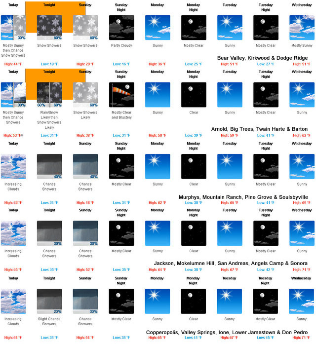
Sunday: Mostly cloudy with a chance of snow showers. Highs 23 to 38 higher elevations…38 to 48 lower elevations. Prevailing northeast winds up to 15 mph with gusts to around 30 mph.
Sunday Night: Mostly clear. Breezy. Lows 13 to 28 higher elevations…28 to 36 lower elevations. Prevailing northeast winds 10 to 25 mph. Gusts up to 45 mph after midnight.
Monday: Sunny. Not as cool. Highs 33 to 48 higher elevations… 50 to 60 lower elevations. Prevailing northeast winds 10 to 20 mph with gusts to around 35 mph.
Monday Night: Clear. Lows 24 to 39.
Tuesday: Sunny, warmer. Highs 50 to 65.
Tuesday Night: Clear. Lows 27 to 42.
Wednesday Through Thursday Night: Mostly clear. Highs 51 to 66. Lows 28 to 43.
Friday: Partly cloudy with a slight chance of rain showers. Highs 46 to 61.
NWS Forecast for: Motherlode Today: Mostly cloudy early in the morning then clearing. Highs 56 to 66. Prevailing southeast winds up to 10 mph shifting to the southwest in the afternoon.
Tonight: Mostly cloudy with a chance of rain showers. Colder. Lows 31 to 39. Prevailing west winds up to 10 mph shifting to the north after midnight.
Sunday: Mostly cloudy with a chance of rain and snow showers. Highs 44 to 58. Prevailing northwest winds up to 15 mph.
Sunday Night: Mostly clear. Lows 31 to 41. Prevailing northeast winds 5 to 15 mph.
Monday: Sunny, warmer. Highs 56 to 68. Prevailing north winds up to 10 mph.
Monday Night: Clear. Lows 36 to 46.
Tuesday: Sunny. Highs 62 to 72.
Tuesday Night: Clear. Lows 38 to 48.
Wednesday Through Thursday Night: Mostly clear. Highs 65 to 75. Lows 38 to 50.
Friday: Partly cloudy with a slight chance of rain showers. Highs 60 to 70.
Special Weather Statement
Special Weather Statement
National Weather Service Sacramento CA
255 PM PST Fri Feb 28 2020
CAZ068-069-010900-
Western Plumas County/Lassen Park-
West Slope Northern Sierra Nevada-
Including the cities of Chester, Quincy, and Blue Canyon
255 PM PST Fri Feb 28 2020
* Snow: 3 to 5 inches expected at pass levels with locally higher
amounts across Sierra mountain summits. A dusting possible down
into the upper foothills.
* Timing: Snow showers will spread from north to south through the
region starting Saturday afternoon while becoming heavier into
the overnight hours. Showers to continue into Sunday with snow
levels falling to around 2,500 feet by the morning hours.
* Temperatures: Saturday`s highs will be in the 40s across the
mountains, while dropping to the upper 20s and 30s on Sunday.
Overnight lows to reach the teens and 20s each night.
* Winds: Gusty winds at times, particularly across ridgetops. Peak
wind gusts reaching 50 to 60 mph from Saturday through Monday.
* Impacts: Snow covered roads, mountain travel delays, and
possible chain controls.
* Synopsis: A cold upper trough arriving from the Gulf of Alaska
will bring snow showers to the Sierra from Saturday afternoon
into Sunday. The dry nature of this system will generally limit
snowfall amounts. In addition to the snow, much cooler
temperatures and gusty winds will accompany this trough.
$$
Winter Weather Advisory
URGENT – WINTER WEATHER MESSAGE
National Weather Service Sacramento CA
204 AM PST Sat Feb 29 2020
…Sierra travel impacts this evening through Sunday morning…
.A weather system will produce a period of moderate snowfall for
the Sierra this evening through tomorrow morning. Snow will begin
late this afternoon with heaviest snow expected tonight for
elevations above 6000 feet. Snow showers will continue through
Sunday morning. A few inches of snow are possible for elevations
down to 4000 feet. Snow combined with gusty winds could create
difficult travel conditions over the Sierra passes. If travel is
necessary, carry chains and expect travel delays.
CAZ068-069-010000-
/O.NEW.KSTO.WW.Y.0004.200301T0000Z-200301T2000Z/
Western Plumas County/Lassen Park-
West Slope Northern Sierra Nevada-
204 AM PST Sat Feb 29 2020
…WINTER WEATHER ADVISORY IN EFFECT FROM 4 PM THIS AFTERNOON TO
NOON PST SUNDAY ABOVE 6000 FEET…
* WHAT…Snow expected. Plan on slippery road conditions. Total
snow accumulations of 4 to 6 inches, with localized amounts up
to 8 inches, are expected.
* WHERE…Western Plumas County/Lassen Park and West Slope
Northern Sierra Nevada.
* WHEN…4 PM today to noon Sunday.
* ADDITIONAL DETAILS…Be prepared for reduced visibilities at
times.
PRECAUTIONARY/PREPAREDNESS ACTIONS…
A Winter Weather Advisory for snow means periods of snow will
cause primarily travel difficulties. Be prepared for snow covered
roads and limited visibilities, and use caution while driving.
The latest road conditions for the state you are calling from can
be obtained by calling 5 1 1.
$$
A Bit of Winter Returns with Snow Levels Dropping to 4,000 ft After Midnight added by admin on
View all posts by admin →