

Arnold, CA…Butte Fire Containment reached 20% overnight. They are starting to make significant progress on dozer lines. Fire behavior remained moderate throughout the night moving North and East. Firefighters continue to fight the fire aggressively but critical fuel moisture levels, steep terrain, and limited fire access continue to provide challenges for firefighters. ***Damage Assessment teams have arrived and started evaluations of damaged and destroyed structures***
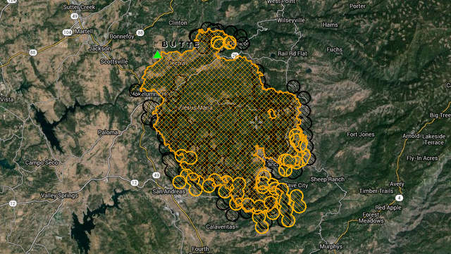
Above Is An Unofficial Heat Map Of Fire. The Good News Today Is Heat Is Down Overall. The Second Map & Link Is A More Detailed Map.
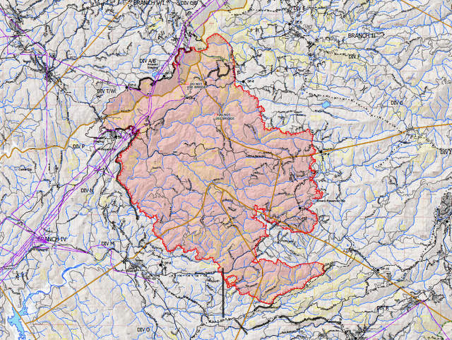
Butte Fire
Butte Fire Incident Information:
Last Updated: September 13, 2015 7:30 am
Date/Time Started: September 9, 2015 2:26 pm
Administrative Unit: CAL FIRE Amador – El Dorado Unit
County: Amador & Calaveras Counties
Location: Butte Mountain Road, east of Jackson
Acres Burned – Containment: 65,215 acres – 20% contained
Structures Threatened: 6,400
Structures Destroyed: 86 homes, 51 outbuildings
Evacuations: Mandatory Evacuation Orders:
San Andreas at Pope, West Murray Creek, Lewis, Miller, San Andreas Elementary, Goldstrike, Mountain Ranch East to Windmill, Wimbledon Drive, Forest Hill, and Turner Court. Please leave the area immediately.
(Amador County) Canyon View, Fig Tree Lane, and Ponderosa Way; the Town of Pine Grove to include all areas South of Hwy 88 from West Clinton Road, East to Ranch Drive. Inclusive of the Communities of Ranch House Estates, Pine Acres, Jackson Pines, Pine Grove Ranchettes and Lake Tabeau.
(Calaveras County) Town of Mokelumne Hill, East of Hwy 49 from the Amador/Calaveras County line South to Goldstrike Road. South on Goldstrike Road to the Community of San Andreas. Rural areas East of San Andreas to Mountain Ranch Road. Mountain Ranch Road to Calaveritas Road to Fourth Crossing. Fourth Crossing to Hwy 49. East side of Hwy 49 South to North side of Hwy 4 (Angels Camp). North side of Hwy 4 East to Town of Arnold. All of SR 26 from Mokelumne Hill North to the Amador/Calaveras County line. To include the communities of Glencoe, Westpoint, and Wilseyville. San Andreas at Pope, West Murray Creek, Lewis, Miller, San Andreas Elementary, Goldstrike, Mountain Ranch East to Windmill, Wimbledon Drive, Forest Hill, and Turner Court.
Evacuations Advisory:
(Amador County) Hwy 88 from Ranch Road East to Tiger Creek Road (Red Corral and Buckhorn Areas).
(Calaveras County) Town of Mokelumne Hill, East of Hwy 49 from the Amador/Calaveras County line South to Goldstrike Road. South on Goldstrike Road to the Community of San Andreas. Rural areas East of San Andreas to Mountain Ranch Road. Mountain Ranch Road to Calaveritas Road to Fourth Crossing. Fourth Crossing to Hwy 49. East side of Hwy 49 South to North side of Hwy 4 (Angels Camp). North side of Hwy 4 East to Town of Arnold. All of SR 26 from Mokelumne Hill North to the Amador/Calaveras County line. To include the communities of Glencoe, Westpoint, and Wilseyville. San Andreas at Pope, West Murray Creek, Lewis, Miller, San Andreas Elementary, Goldstrike, Mountain Ranch East to Windmill, Wimbledon Drive, Forest Hill, and Turner Court.
Evacuation Centers:Red Cross: 925-588-6678 Jackson Rancheria Hotel, 12222 New York Ranch Road, Jackson Jenny Lind Veterans Hall, 189 Pine Street, Valley Springs, CA Good Samaritan Church, 4684 Baldwin Street, Valley Springs Burson Full Gospel Church, 3201 Hwy 12, Burson Glory Bound Fellowship, 3061 Hwy 12, Burson Copperopolis Elementary School, 217 School Street, Copperopolis
Large Animal Pet Shelters: (Calaveras) Calaveras County Fairgrounds (Amador) Amador County Fairgrounds, contact Kelly Reason at 530-503-5233
Cooperating Agencies: BLM, Cal OES, PG&E, Amador County Sheriff, Calaveras County Sheriff, CHP, Amador Fire Protection District, Calaveras PUD, CDCR, Sutter Creek Fire Department, CAL-TRANS, State Parks
Total Fire Personnel: 4,163
Total Fire Engines: 474
Total Fire crews: 79
Total Helicopters: 17
Total Dozers: 102
Total Water Tenders: 55
Long/Lat: -120.70418, 38.32974
Conditions: Fire behavior remained moderate throughout the night moving North and East. Firefighters continue to fight the fire aggressively but critical fuel moisture levels, steep terrain, and limited fire access continue to provide challenges for firefighters. ***Damage Assessment teams have arrived and started evaluations of damaged and destroyed structures***
Road Closures:
(Amador County) Clinton Road at Butte Mountain Road (Both Ends) Butte Mountain Road Cutoff at Clinton Road. Amador Lane at Clinton Road, Electra at SR 49, Ponderosa Road at Tabeaud, Access to Lake Tabeaud is closed; Hwy 88 at W. Clinton Road, Hwy 88 at Irish Town Road, Hwy 88 at Tabeaud Road, Hwy 88 at Aqueduct Circle, Highway 88 at Mount Zion, SR 26 South of Hwy 88.
(Calaveras County) SR 26 from Mokelumne Hill to Ridge Road; Ridge Road closed to Railroad Flat Road; Railroad Flat Road closed to Mountain Ranch Road; Mountain Ranch Road closed to Hwy 49; Michel Road is closed.
If you are interested in making Donations please check out the following link: More Information
Phone Numbers (530) 647-5218 (Fire Information Line)
Phone Numbers (209) 754-5527 (Fire Information Line)
Butte Fire Morning Update…65,215 Acres, 4,163 Personnel, 474 Engines, 55 Water Tenders, Homes Lost 86, Outbuildings Lost 51, 79 Fire Crews, 17 Helicopters, 102 Bulldozers, added by admin on
View all posts by admin →