

San Andreas, CA…Fire behavior remained moderate throughout the day moving southeast allowing crews to be more effective in perimeter control. Firefighters continue to fight the fire aggressively but critical fuel moisture levels, steep terrain, and limited fire access continue to provide challenges. Damage Assessment teams have arrived and started evaluations of damaged and destroyed structures. The sad news is that the numbers of destroyed homes has soared as a result…
Butte Fire
Butte Fire Incident Information:
Last Updated: September 13, 2015 9:30 pm
Date/Time Started: September 9, 2015 2:26 pm
Administrative Unit: CAL FIRE Amador – El Dorado Unit
County: Amador & Calaveras Counties
Location: east of Jackson
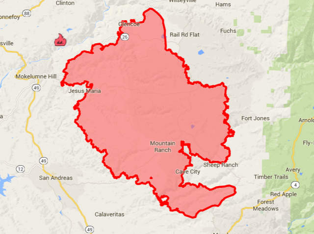
Acres Burned – Containment: 65,300 acres – 25% contained
Structures Threatened: 6,400
Structures Destroyed: 135 residences, 79 outbuildings, 4 structures damaged
Evacuations: Mandatory Evacuation Orders:
San Andreas at Pope, West Murray Creek, Lewis, Miller, San Andreas Elementary, Goldstrike, Mountain Ranch East to Windmill, Wimbledon Drive, Forest Hill, and Turner Court. Please leave the area immediately.
(Amador County) Canyon View, Fig Tree Lane, and Ponderosa Way; Tabeau Road south of Arrowhead to Amador Road, Ranch Drive and Aqueduct Grove Road.
(Calaveras County) Town of Mokelumne Hill, East of Hwy 49 from the Amador/Calaveras County line South to Goldstrike Road. South on Goldstrike Road to the Community of San Andreas. Rural areas East of San Andreas to Mountain Ranch Road. Mountain Ranch Road to Calaveritas Road to Fourth Crossing. Fourth Crossing to Hwy 49. East side of Hwy 49 South to North side of Hwy 4 (Angels Camp). North side of Hwy 4 East to Town of Arnold. All of SR 26 from Mokelumne Hill, North to the Amador/Calaveras County line. To include the communities of Glencoe, Westpoint, and Wilseyville. San Andreas at Pope, West Murray Creek, Lewis, Miller, San Andreas Elementary, Goldstrike, Mountain Ranch East to Windmill, Wimbledon Drive, Forest Hill, and Turner Court.
Evacuations Advisory:
(Amador County) Hwy 88 from Ranch Road East to Tiger Creek Road (Red Corral and Buckhorn Areas).
(Calaveras County) City of Angels Camp, Hwy 49 South to Hwy 4 South at the city limits of Angels Camp. Town of Arnold, Northwest of Hwy 4 includes sub-divisions of Lakemont, Mill Woods and Meadowmont. Hwy 4 North to Sheep Ranch Road/Blue Lake Springs sub-division, Big Trees State Park, Town of Dorrington, Town of Murphys and Forest Meadows. Town of San Andreas. Poole Station Road, Carroll Kennedy Road, Cement Plant Road, Demearest Mine Road, Oak Valley Road, Gelding Road, Stallion Road, Deer Creek Road, Copello Road.
Evacuation Centers:
Red Cross: 925-588-6678
Jackson Rancheria Hotel, 12222 New York Ranch Road, Jackson
Jenny Lind Veterans Hall, 189 Pine Street, Valley Springs, CA
Good Samaritan Church, 4684 Baldwin Street, Valley Springs
Burson Full Gospel Church, 3201 Hwy 12, Burson
Glory Bound Fellowship, 3061 Hwy 12, Burson
Copperopolis Elementary School, 217 School Street, Copperopolis
Large Animal Pet Shelters: (Calaveras) Calaveras County Fairgrounds (Amador) Amador County Fairgrounds, contact Kelly Reason at 530-503-5233
Cooperating Agencies: BLM, Cal OES, PG&E, Amador County Sheriff, Calaveras County Sheriff, CHP, Amador Fire Protection District, Calaveras PUD, CDCR, Sutter Creek Fire Department, CAL-TRANS, State Parks
Total Fire Personnel: 4,541
Total Fire Engines: 499
Total Fire crews: 87
Total Helicopters: 18
Total Dozers: 118
Total Water Tenders: 57
Long/Lat: -120.70418, 38.32974
Conditions: Fire behavior remained moderate throughout the day moving southeast allowing crews to be more effective in perimeter control. Firefighters continue to fight the fire aggressively but critical fuel moisture levels, steep terrain, and limited fire access continue to provide challenges. ***Damage Assessment teams have arrived and started evaluations of damaged and destroyed structures***
Road Closures:
(Amador County) Clinton Road at Butte Mountain Road (Both Ends) Butte Mountain Road Cutoff at Clinton Road. Amador Lane at Clinton Road, Electra at SR 49, Ponderosa Road at Tabeau, Access to Lake Tabeau is closed; Aqueduct Grove Road at Hwy 88, SR 26 South of Hwy 88.
(Calaveras County) SR 26 from Mokelumne Hill to Ridge Road; Ridge Road closed to Railroad Flat Road; Railroad Flat Road closed to Mountain Ranch Road; Mountain Ranch Road closed to Hwy 49; Michel Road is closed.
RE-POPULATION PHASE I
All residences on East Clinton Road, to Clinton Road
Residences on Irish Town Road and Clinton Road to East Clinton Road
All residences on Mount Zion/Lookout Road area
All residences on Tabeau Road from Hwy 88 to South of Arrowhead
All residences on Clinton Road from Amador Lane/Tabeau Road to East/West Clinton split
For more information on Re-Population visit the following link: Re-Population News Release Sunday, September 13, 2015 at 4pm
RE-POPULATION PHASE II
Additional Evacuations have been lifted and are open to RESIDENTS ONLY: For a list of the applicable roads please visit the attached link
RePopulation News Release Phase II:Re-Population Sunday, September 13 at 9pm
If you are interested in making Donations please check out the following link: More Information
Phone Numbers (530) 647-5218 (Fire Information Line)
Phone Numbers (209) 754-5527 (Fire Information Line)
Butte Fire Evening Update…65,300 Acres, 25% Contained, 135 Homes Destroyed, 79 Outbuildings, added by admin on
View all posts by admin →