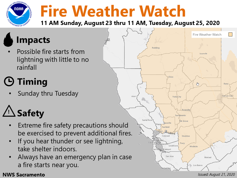
Sacramento, CA…Thunderstorms with little to no rainfall are possible once again Sunday – Tuesday. These could produce fire starts, so a Fire Weather Watch has been issued. Remember, always have an emergency plan during fire season in case a fire starts near you. readyforwildfire.org
Fire Weather Watch
URGENT – FIRE WEATHER MESSAGE
National Weather Service Sacramento CA
1027 AM PDT Fri Aug 21 2020
…FIRE WEATHER WATCH FOR DRY THUNDERSTORMS LATE WEEKEND INTO
EARLY NEXT WEEK…
.Moisture will advance northward later this weekend and early
next week, associated with what will be leftover of Tropical
Storm Genevieve as it weakens. This remnant moisture will lead to
the increasing potential for isolated dry thunderstorms for much
of Northern California. Lightning with these dry thunderstorms
will have the potential to start new fires.
CAZ213>221-263-266>269-279-220800-
/O.NEW.KSTO.FW.A.0003.200823T1800Z-200825T1800Z/
Eastern Portion of Shasta/Trinity NF-
Burney Basin and Northeast Plateau in Shasta County Including
Northwest Lassen NF north of Lassen NP-
Northern Sacramento Valley to Southern Tehama County Line Below
1000 Ft-
Central Sacramento Valley in Glenn, Colusa, Yuba, Northern
Sutter, and Butte County Below 1000 Ft-
Southern Sacramento Valley in Yolo-
Sacramento Far Western Placer, southern Sutter and Solano County
Below 1000 Ft-Carquinez Strait and Delta-
Northern San Joaquin Valley in San Joaquin and Stanislaus
Counties Below 1000 ft-
Southern Motherlode From 1000 to 3000 Ft. Includes portions of
Calaveras-Tuolumne Unit-Stanislaus NF West of the Sierra Crest-
Southeast Edge Shasta-Trinity NF and Western Portions of Tehama-
Glenn Unit-
Northern Sierra Foothills from 1000 to 3000 Ft. Includes portions
of Shasta-Trinity and Butte Units-
Northern Motherlode From 1000 to 3000 Ft. Includes portions of
Nevada-Yuba-Placer-Amador and ElDorado Units-
Northern Sierra Including Lassen NP and Plumas and Lassen NF/S
West of the Sierra Crest (West of Evans Peak-Grizzly Peak-
Beckworth Peak)-
Northern Sierra Including the Tahoe and ElDorado NF/S West of the
Sierra Crest-Eastern Mendocino NF-
1027 AM PDT Fri Aug 21 2020
…FIRE WEATHER WATCH IN EFFECT FROM SUNDAY MORNING THROUGH
TUESDAY MORNING FOR DRY LIGHTNING FOR FIRE WEATHER ZONES 213,
214, 215, 216, 217, 218, 219, 220, 221, 263, 266, 267, 268, 269,
AND 279…
The National Weather Service in Sacramento has issued a Fire
Weather Watch, which is in effect from Sunday morning through
Tuesday morning.
* AFFECTED AREA…Sacramento Valley, northern San Joaquin Valley,
northern Sierra Nevada, and all adjacent foothills. Includes
Includes Shasta-Trinity National Forest, Lassen Volcanic
National Park, and portions of Plumas, Lassen and Mendocino
National Forests.
* THUNDERSTORMS…Isolated dry thunderstorms will develop on
Sunday afternoon, continuing overnight into Monday morning.
Potential for dry thunderstorms may linger into Tuesday.
* IMPACTS…Any fires that develop will likely spread rapidly.
Outdoor burning is not recommended.
PRECAUTIONARY/PREPAREDNESS ACTIONS…
A Fire Weather Watch means that critical fire weather conditions
are forecast to occur. Listen for later forecasts and possible
Red Flag Warnings.


