


Arnold, CA…Detailed forecast for the West Slope Northern Sierra Nevada from the National Weather Service. Today
Partly cloudy in the morning then becoming mostly cloudy. Not as cool. Highs 34 to 49 higher elevations…44 to 54 lower elevations. Prevailing northeast winds up to 10 mph in the morning becoming light. Tonight Mostly cloudy. At higher elevations, a slight chance of snow showers in the evening, then a chance of snow showers after midnight. At lower elevations, a chance of rain and snow showers after midnight. Lows 21 to 36 higher elevations…34 to 42 lower elevations. Prevailing south winds up to 10 mph with gusts to around 25 mph.
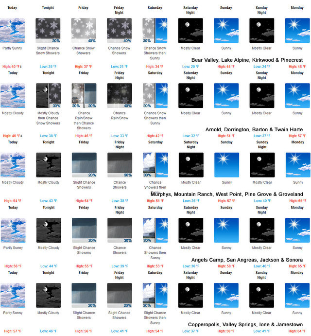

Friday
Mostly cloudy. At lower elevations, a chance of rain and snow showers in the morning, then a chance of rain showers in the afternoon. At higher elevations, a chance of snow showers in the morning, then a chance of rain and snow showers in the afternoon. Highs 32 to 47 higher elevations…40 to 54 lower elevations. No snow accumulation lower elevations…up to 1 inch higher elevations. Snow level 5500 feet increasing to 6500 feet in the afternoon. Prevailing south winds up to 10 mph with gusts to around 30 mph.
Friday Night
Mostly cloudy with a chance of rain and snow showers. Colder. Lows 17 to 32 higher elevations…31 to 37 lower elevations. No snow accumulation lower elevations…up to 3 inches higher elevations. Snow level 5000 feet. Prevailing southwest winds up to 10 mph with gusts to around 30 mph…except southwest 10 to 25 mph over ridges.
Saturday
Mostly cloudy with a chance of snow showers in the morning, then mostly sunny in the afternoon. Highs 30 to 45 higher elevations…41 to 51 lower elevations. Prevailing west winds up to 10 mph with gusts to around 25 mph.
Saturday Night
Clear. Lows 20 to 35.
Sunday
Sunny. Not as cool. Highs 42 to 57.
Sunday Night
Clear. Lows 24 to 39.
Monday Through Tuesday Night
Mostly clear. Highs 47 to 62. Lows 26 to 41.
Wednesday
Mostly sunny. Highs 40 to 55.
Detailed forecast for Motherlode
Today
Mostly sunny in the morning then becoming mostly cloudy. Highs 50 to 60. Light winds becoming south up to 10 mph in the afternoon.
Tonight
Mostly cloudy. A chance of rain showers after midnight. Lows 38 to 48. Light winds.
Friday
Cloudy with a chance of rain showers. Highs 47 to 59. Light winds.
Friday Night
Mostly cloudy. A slight chance of rain showers in the evening, then a chance of rain showers after midnight. Lows 34 to 42. Light winds.
Saturday
Mostly cloudy with a chance of rain showers in the morning, then mostly sunny in the afternoon. Highs 47 to 57. Light winds becoming northwest up to 10 mph in the afternoon.
Saturday Night
Clear. Lows 33 to 39.
Sunday
Sunny. Highs 54 to 62.
Sunday Night Through Monday Night
Clear. Lows 37 to 46. Highs 60 to 68.
Tuesday And Tuesday Night
Mostly clear. Highs 62 to 70. Lows 38 to 46.
Wednesday
Mostly sunny. Highs 55 to 63.
Mother Nature Bringing A Bit More Moisture in Solid & Liquid Forms added by admin on
View all posts by admin →