


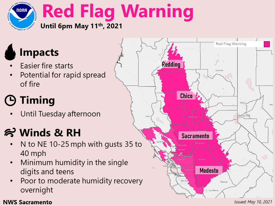
Sacramento, CA…Gusty north to east wind, low humidity and unseasonably dry fuels will continue critical fire weather conditions over portions of the Valley, Delta and surrounding foothills below 2000 feet. Strongest winds expected along the west side of the Sacramento Valley, and through favorably oriented gaps and canyons in the surrounding foothills, through early Tuesday. Breezy winds continue through the day Tuesday over the western side of the Valley and the Delta, along with very low afternoon humidity levels. Winds weaken Tuesday night and become onshore for mid to late week, with humidity levels trending up. The Full Warning is below…
Red Flag Warning
URGENT – FIRE WEATHER MESSAGE
National Weather Service Sacramento CA
230 AM PDT Mon May 10 2021
…Critical Fire Weather Conditions Through Tuesday Afternoon for
Elevations Below 2000 Feet…
.Gusty north to east wind, low humidity and unseasonably dry
fuels will continue critical fire weather conditions over
portions of the Valley, Delta and surrounding foothills below
2000 feet. Strongest winds expected along the west side of the
Sacramento Valley, and through favorably oriented gaps and
canyons in the surrounding foothills, through early Tuesday.
Breezy winds continue through the day Tuesday over the western
side of the Valley and the Delta, along with very low afternoon
humidity levels. Winds weaken Tuesday night and become onshore for
mid to late week, with humidity levels trending up.
CAZ215>219-263-279-102300-
/O.CON.KSTO.FW.W.0002.000000T0000Z-210512T0100Z/
Northern Sacramento Valley to Southern Tehama County Line Below
1000 Ft-
Central Sacramento Valley in Glenn, Colusa, Yuba, Northern
Sutter, and Butte County Below 1000 Ft-
Southern Sacramento Valley in Yolo-
Sacramento Far Western Placer, southern Sutter and Solano County
Below 1000 Ft-Carquinez Strait and Delta-
Northern San Joaquin Valley in San Joaquin and Stanislaus
Counties Below 1000 ft-Southeast Edge Shasta-
Trinity NF and Western Portions of Tehama-Glenn Unit-
Eastern Mendocino NF-
230 AM PDT Mon May 10 2021
…RED FLAG WARNING REMAINS IN EFFECT UNTIL 6 PM PDT TUESDAY FOR
GUSTY WIND AND LOW HUMIDITY FOR FIRE WEATHER ZONES 215, 216, 217,
218, 219, 263, AND 279…
* AFFECTED AREA…Sacramento Valley, Delta, northern San Joaquin
Valley and surrounding terrain below 2000 feet elevation.
* WIND…North to east 10 to 25 mph with local gusts up to 40 mph.
Strongest wind expected through early Tuesday, west of
Interstate 5 and into the Coast Range. Breezy winds continue
through Tuesday afternoon.
* HUMIDITY…Minimum daytime humidity in the single digits or
teens. Poor to moderate overnight humidity recovery of 20 to 50
percent.
* IMPACTS…Any fires that develop will likely spread rapidly.
Outdoor burning is not recommended.
PRECAUTIONARY/PREPAREDNESS ACTIONS…
A Red Flag Warning means that critical fire weather conditions
are either occurring now, or will shortly. A combination of
strong winds, low relative humidity, and warm temperatures can
contribute to extreme fire behavior.
&&
Interact with us via social media
www.facebook.com/nws.sacramento
www.twitter.com/nwssacramento
$$
URGENT – FIRE WEATHER MESSAGE
National Weather Service Sacramento CA
230 AM PDT Mon May 10 2021
…Critical Fire Weather Conditions Through Tuesday Afternoon for
Elevations Below 2000 Feet…
.Gusty north to east wind, low humidity and unseasonably dry
fuels will continue critical fire weather conditions over
portions of the Valley, Delta and surrounding foothills below
2000 feet. Strongest winds expected along the west side of the
Sacramento Valley, and through favorably oriented gaps and
canyons in the surrounding foothills, through early Tuesday.
Breezy winds continue through the day Tuesday over the western
side of the Valley and the Delta, along with very low afternoon
humidity levels. Winds weaken Tuesday night and become onshore for
mid to late week, with humidity levels trending up.
CAZ213-220-266-267-102300-
/O.CON.KSTO.FW.W.0002.000000T0000Z-210511T0100Z/
Eastern Portion of Shasta/Trinity NF-
Southern Motherlode From 1000 to 3000 Ft. Includes portions of
Calaveras-Tuolumne Unit-
Northern Sierra Foothills from 1000 to 3000 Ft. Includes portions
of Shasta-Trinity and Butte Units-
Northern Motherlode From 1000 to 3000 Ft. Includes portions of
Nevada-Yuba-Placer-Amador and ElDorado Units-
230 AM PDT Mon May 10 2021
…RED FLAG WARNING REMAINS IN EFFECT UNTIL 6 PM PDT THIS EVENING
FOR GUSTY WINDS AND LOW HUMIDITY FOR FIRE WEATHER ZONES 213, 220,
266, AND 267…
* AFFECTED AREA…Southern Cascade and northern Sierra foothills
below 2000 feet elevation.
* WIND…North to east 15 to 25 mph with local gusts up to 40 mph.
Strongest wind expected through favorably oriented gaps and
canyons in the foothills.
* HUMIDITY…Minimum daytime humidity of 10 to 15 percent. Poor
overnight humidity recovery of 20 to 35 percent.
* IMPACTS…Any fires that develop will likely spread rapidly.
Outdoor burning is not recommended.
PRECAUTIONARY/PREPAREDNESS ACTIONS…
A Red Flag Warning means that critical fire weather conditions
are either occurring now, or will shortly. A combination of
strong winds, low relative humidity, and warm temperatures can
contribute to extreme fire behavior.
&&
Interact with us via social media
www.facebook.com/nws.sacramento
www.twitter.com/nwssacramento
$$
URGENT – FIRE WEATHER MESSAGE
National Weather Service San Francisco CA
551 AM PDT Mon May 10 2021
…Red Flag Warning for the North and East Bay Hills, as well as
the East Bay Interior Valleys, through 6 pm Tuesday for offshore
winds and low humidity…
.The Red Flag Warning continues through Tuesday afternoon.
Conditions have briefly moderated but offshore winds will
gradually increase again today into tonight across the North and
East Bay hills. The latest forecasts now suggest conditions will
worsen tonight into Tuesday morning as another burst of moderate
to strong offshore winds develops in the hills. This will occur
with very low humidity values and drought stressed fuels. Winds
will ease through the day Tuesday but warm and dry weather will
persist through Tuesday afternoon.
CAZ507-510-511-102200-
/O.CON.KMTR.FW.W.0002.000000T0000Z-210512T0100Z/
North Bay Mountains-East Bay Interior Valleys-
East Bay Hills and the Diablo Range-
551 AM PDT Mon May 10 2021
…RED FLAG WARNING REMAINS IN EFFECT UNTIL 6 PM PDT TUESDAY FOR
OFFSHORE WIND AND LOW HUMIDITY FOR THE NORTH AND EAST BAY HILLS
AS WELL AS THE INTERIOR VALLEYS OF THE EAST BAY…
* AFFECTED AREA…Fire Weather Zone 507 North Bay Mountains,
Fire Weather Zone 510 East Bay Interior Valleys and Fire
Weather Zone 511 East Bay Hills and the Diablo Range.
* TIMING…Through 6 pm Tuesday. The most dangerous time will be
the overnight hours of Monday evening into Tuesday morning when
another burst of moderate to strong offshore winds will impact
the hills.
* WINDS…Elevations below 2000 feet…northerly winds 10 to 15
mph with gusts up to 40 mph. Elevations from 2000 feet and
above…northerly winds of 15 to 25 mph with peak gusts to
around 50 mph and local gusts to 60 mph highest peaks.
* RELATIVE HUMIDITY…As low as 5 to 15 percent, driest Monday
and Tuesday afternoon with little or no recovery Monday night.
* TEMPERATURES…In the 80s and lower 90s afternoon hours with
nighttime lows 50s in the valleys and 60s in the hills where
winds are strongest.
* IMPACTS…New ignitions will experience rapid fire growth.
PRECAUTIONARY/PREPAREDNESS ACTIONS…
A Red Flag Warning means that critical fire weather conditions
are either occurring now…or will shortly. A combination of
strong winds…low relative humidity…and warm temperatures can
contribute to extreme fire behavior.
&&
Critical Fire Weather Conditions Continue Through Tuesday Afternoon! added by admin on
View all posts by admin →