

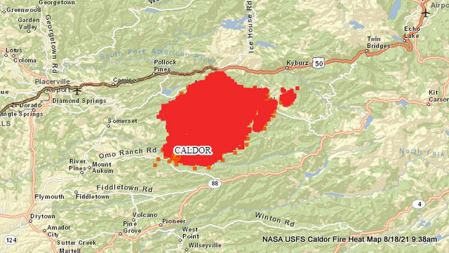
Grizzly Flats, CA…The Caldor Fire continued to experience unprecedented fire behavior and growth due to extremely dry fuels pushed by the south west winds. A red flag warning is still in effect for the fire area through 8:00 PM tonight with winds switching to the northeast. These winds, combined with low humidity and extremely dry fuels, lead to critical fire weather conditions. The communities in proximity to the Caldor Fire experienced multiple evacuations yesterday due to the fast-moving fire. Some structures were damaged or destroyed. Structure assessment teams will be evaluating these areas as soon as it is safe for them to do so.
The rapidly changing, complexity and immediate needs of the incident have prevented assessing the quantity of resources resulting in no reported changes to the documented numbers in this update. We received additional resources and immediately utilized them on the fire. Significant resources have been ordered to be assigned to this incident.
Please register for Code Red through the local County Sheriff’s Office El Dorado County Code Red: https://ready.edso.org/ Amador County Code Red: https://www.amadorsheriff.org/administration-division/codered
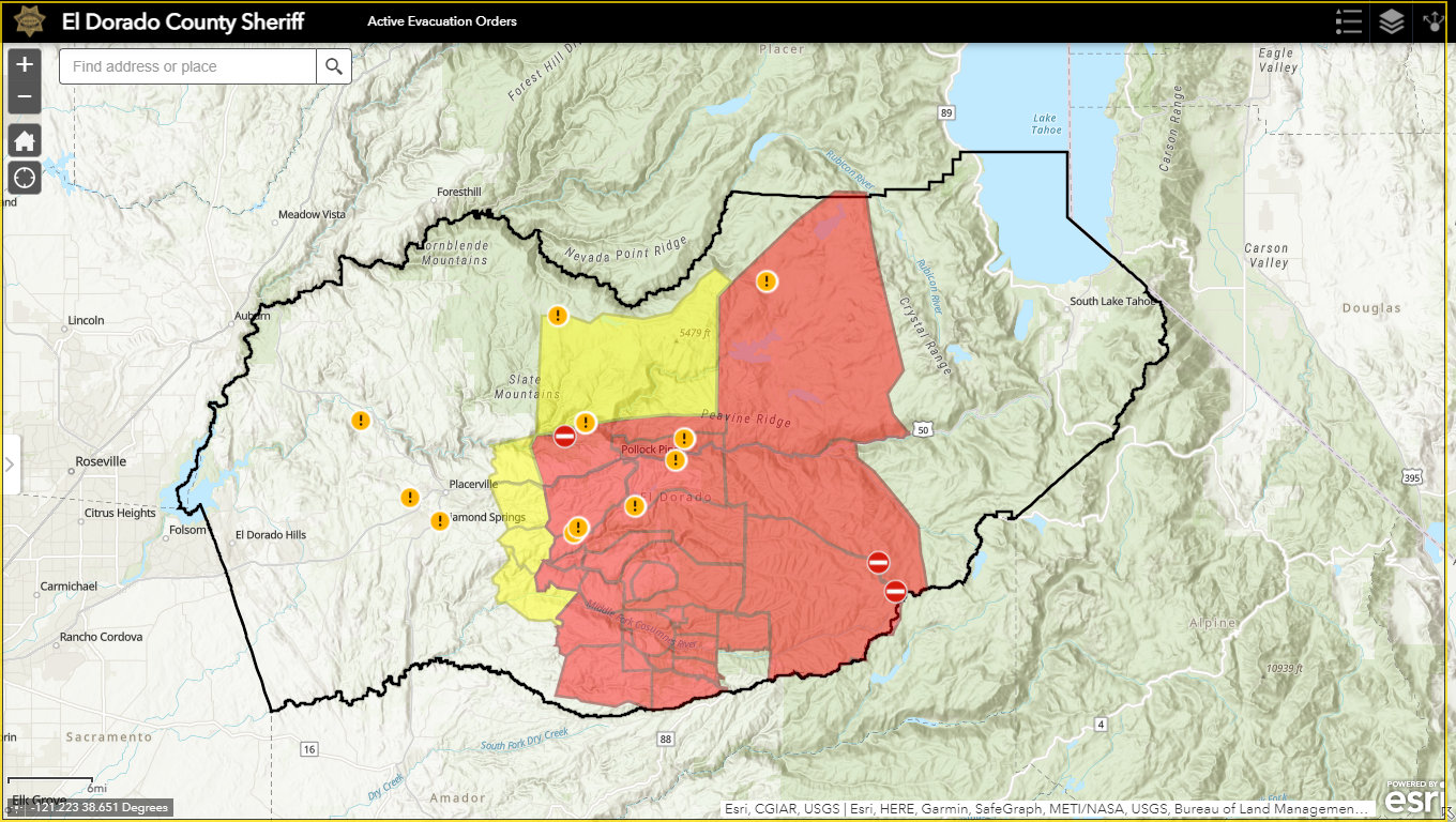
MANDATORY EVACUATON ORDERS:
– Grizzly Flat: The areas on Grizzly Flats Road east of Kendra Way into Grizzly Flats Proper. The areas of Diamond Railroad Grade, Old School House, Sweeney Road, Caldor Road, and steely Ridge.
• Grizzly Flats Road east of four corners in Somerset into Grizzly Flats Proper. The areas of Myers Lane, Varmet Ridge Road, Rodwell Canyon Road, Snowbird Lane, and Mehwald Lane.
• East of Sly Park Road between Highway 50 and Mormon Emigrant Trail to Ice House Road. This includes the communities of Pacific House and Fresh Pond.
• North of Highway 50 ,east of Forebay Road to Ice House Road.
• Intersection of Perry Creek and Hawk Haven , the East side of Fairplay Road from Perry Creek South to Cedarville Road. This includes Slug Gulch, Omo Ranch, and all roads off of Slug Gulch and Omo Ranch.
• All roads off of Omo Ranch from Cedarville Road to Hwy 88.
• The area between Highway 88 and Mormon Emigrant Trail
• South of Highway 50 from Snows Road to Ice House Road.
• Between Highway 50 and Slab Creek from Snows Road to Ice House Road.
South of Highway 50 from Ice House Road to Silver Fork Road. This includes the community of Kyburz.
• North of Highway 50 from Ice House Road to Silver Fork Road to include Ice House Reservoir, Union Valley Reservoir, and Loon Lake.
EVACUATION WARNINGS:
-North of Slab Creek to Wentworth Springs Road between Sand Mountain and Loon Lake.
• Mosquito Road from the bridge North to include the Community of Swansboro.
• North of Highway 50 to Slab Creek between Smith Flat and Snows Road.
• South of Highway 50 to Pleasant Valley between Smith Flat and Snows Road, and North of Pleasant Valley between Holm and Newtown.
• South of Pleasant Valley between Bucks Bar Road and Newtown Road, East of Bucks Bar Road to Mt Aukum Road.
• Southwest of Bucks Bar Road to Ladies Valley Road including the community of Outingdale, Ant Hill Road, Perry Creek Road and Sand Ridge between Ladies Valley Road and Bucks Bar Road.
• East of Mt Aukum Road (E16) from Bucks Bar Road to Omo Ranch Road. North of Omo Ranch Road to the intersection of Omo Ranch Road and Fairplay Road.
• South of Omo Ranch to the El Dorado County Line between Mt Aukum Road (E16) and Fairplay Road to include Coyoteville Road, Cedar Creek and all tributary roads.
– North of Slab Creek to Wentworth Springs Road between Sand Mountain and Loon Lake.
• Mosquito Road from the bridge North to include the Community of Swansboro.
• North of Highway 50 to Slab Creek between Smith Flat and Snows Road.
• South of Highway 50 to Pleasant Valley between Smith Flat and Snows Road, and North of Pleasant Valley between Holm and Newtown.
• South of Pleasant Valley between Bucks Bar Road and Newtown Road, East of Bucks Bar Road to Mt Aukum Road.
– Southwest of Bucks Bar Road to Ladies Valley Road including the community of Outingdale, Ant Hill Road, Perry Creek Road and Sand Ridge between Ladies Valley Road and Bucks Bar Road.
• East of Mt Aukum Road (E16) from Bucks Bar Road to Omo Ranch Road. North of Omo Ranch Road to the intersection of Omo Ranch Road and Fairplay Road.
• South of Omo Ranch to the El Dorado County Line between Mt Aukum Road (E16) and Fairplay Road to include Coyoteville Road, Cedar Creek and all tributary roads.
SHELTER INFORMATION:
An evacuation center is open at:
– Cameron Park CSD, 2502 Country Club Drive, Cameron Park, CA 95682
– Green Valley Church Evacuation Shelter
3500 Missouri Flat Rd., Placerville
-The Fireman’s Hall – FULL
3734 China Garden Road
Diamond Springs, CA 95619
LARGE ANIMAL SHELTER:
– Amador County Fairgrounds, 18621 Sherwood Street, Plymouth, CA 95669 (Empire Street Gate)
SMALL ANIMAL SHELTER:
– Call (530) 621-5795
Engines: 23
Dozers: 10
Helicopters:
Hand Crews: 6
Total Personnel:242
Air Tankers: Multiple aircraft are available as needed throughout the state.
Cooperating Agencies: El Dorado County Sheriff’s Office, Pioneer Fire Protection District, Sierra Pacific Industries, PG&E, Pioneer FD, CHP, El Dorado Irrigation District, El Dorado County.
The Caldor Fire Morning Update, 53,772 Acres, 0% Contained & 242 Total Personnel added by admin on
View all posts by admin →