

Grizzly Flat, CA…Evacuation Warnings, Effective Immediately, Douglas County, Nevada. Douglas County is asking the following communities to be on the alert and start preparing for potential evacuations. Evacuations have not been ordered for the following areas at this time; however, there is potential for evacuation warnings to heighten to evacuation orders in the near future. The communities possibly affected are: Douglas County, NV – Evacuation Warning. The following zone is affected: Zone 2, Any homes or property located on Foothill Road from Centerville Lane north to Muller. Included in this zone is the valley side of Kingsbury Grade and any homes that are accessed by Foothill Road between Centerville Lane and Muller Lane.
These communities are asked to be on the alert and start preparing for potential evacuations. Evacuations have not been ordered at this time, however there is potential for evacuation orders in the near future and road closures are imminent. Please stay vigilant, pay attention to emergency phone alerts, and have a plan in place.
Safety Message: Have a transportation plan for animals and livestock. Think about fuel, medications, keepsakes, documents and groceries you might need. Think about your loved ones on oxygen or anyone who may need assistance leaving their home. Living with Fire has a Wildfire Evacuation Checklist for reference. To view, visit the following link: https://www.livingwithfire.com/wpcontent/uploads/2018/10/Evacuation-Checklist-2020-one-page.pdf
Should evacuations occur, you will receive an emergency alert notification on your phone, and may be asked to leave your home by emergency responders. It is not recommended to wait for someone to visit your home. If you feel unsafe, leave the area. If you do not have a cell phone or landline, please keep in contact with friends, neighbors, co-workers, and family.
Evacuation Shelters:
Douglas County Community and Senior Center- Douglas County Residents Only
1329 Waterloo Lane, Gardnerville, NV
Reno Sparks Convention Center
4590 South Virginia Street, Reno, NV
Lyon County Fair Grounds – Dry Camping Only
100 95A East, Yerington, NV
Dayton Event Center/Rodeo Grounds – Dry Camping Only
500 Schaad Lane, Dayton, NV
CURRENT SITUATION:
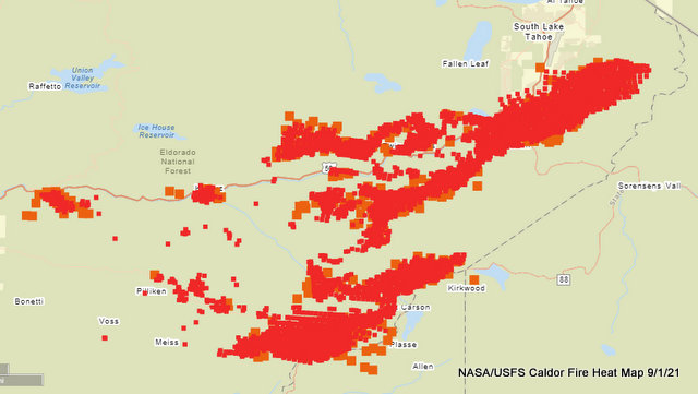
The fire remained very active overnight due to the extremely poor humidity recovery and warm temperatures. Spotting continued to occur with spots being found up to .5 miles away from the edge of the fire. The fire continued to back down towards Highway 50 in Division F & G with slow rates of spread. Today firefighters will face more dry conditions and strong winds with gusts up to 35-40 mph in some areas. The current red flag warning remains in effect through 11:00 p.m. on 9/1/21.
To better provide public and firefighter safety due to extreme fire conditions throughout Northern California, and strained firefighter resources throughout the Country, the USDA Forest Service Pacific Southwest Region is announcing a temporary closure of nine National Forests. This closure will be effective on August 22, 2021, at 11:59 p.m. through September 6, 2021, at 11:59 p.m. The closure order can be found at https://tinyurl.com/USFSClosure.
Local Assistance Center:
Address: 6699 Campus Drive, Placerville, CA 95667. Located at Folsom Lake Community College, El Dorado Campus, Fitness Center Building.
Hours: Monday through Friday 10:00 a.m. to 5:00 p.m., Wednesdays 1:00 p.m. to 7:00 p.m.
AMADOR COUNTY
Evacuation Order:
- South of Highway 88 along the Amador/El Dorado County line from Dufrene Road, due east to the Amador/Alpine County line and from the Amador/Alpine County line north to Highway 88. This includes the area of Kirkwood Lake.
Evacuation Warning:
- South of the Amador/El Dorado County line along Highway 88 from Dufrene Road west to Omo Ranch Road.
- North of Tiger Creek Road east to Salt Springs Reservoir Road to the east end of the Salt Springs Reservoir.
- West of the Amador/Alpine County line to Highway 88.
- East of Highway 88 to the Amador/Alpine County line
Road Closures:
- Highway 88 is closed between Peddlers Ridge and the Highway 88/89 interchange.
EL DORADO COUNTY
Evacuation Orders:
- Grizzly Flat: The areas on Grizzly Flats Road east of Kendra Way into Grizzly
- Flats Proper. The areas of Diamond Railroad Grade, Old School House, Sweeney Road, Caldor Road, and Steely Ridge.
- Grizzly Flats Road east of four corners in Somerset into Grizzly Flats Proper.
- The areas of Myers Lane, Varmet Ridge Road, Rodwell Canyon Road, Snowbird Lane, and Mehwald Lane.
- East of Sly Park Road between Highway 50 and Mormon Emigrant Trail to Ice House Road. This includes the communities of Pacific House and Fresh Pond.
- North of Highway 50, east of Forebay Road to Ice House Road.
- Intersection of Perry Creek and Hawk Haven, the East side of Fairplay Road from Perry Creek South to Cedarville Road. This includes Slug Gulch, Omo Ranch, and all roads off of Slug Gulch.
- All roads off of Omo Ranch from Cedarville Road to Hwy 88.
- The area between Highway 88 and Mormon Emigrant Trail
- South of Highway 50 from Snows Road to Ice House Road.
- Between Highway 50 and Slab Creek from Snows Road to Ice House Road.
- South of Highway 50 from Ice House Road to Silver Fork Road. This includes the community of Kyburz.
- North of Highway 50 from Ice House Road to Silver Fork Road to include Ice House Reservoir, Union Valley Reservoir, and Loon Lake.
- Silver Fork Road in Kyburz east to Twin Bridges.
- North and south in a line extending from Twin Bridges to the Placer County line and south to the Amador County line.
- From Twin Bridges east to Echo Summit.
- From Highway 50 South to Amador/ Alpine County Line.
- From Highway 50 North to Flag Pole Peak.
- Pleasant Valley Road and all intersecting roads extending south from Newtown Road to the intersection of E-16 (Mt Aukum Road).
- All roads accessed from E-16 (Mt Aukum Road) between Pleasant Valley Road and Bucks Bar Road.
- This includes all roads and residences accessed from Moon-Shadow and Gopher Hole Road off Bucks Bar Road.
- Christmas Valley from Highway 89 West to Echo Summit
- Highway 89 due West to Watershed Ridge/Echo Summit and South to the Amador/El Dorado County line.
- The area from Luther Pass Road, north along the El Dorado/Alpine County line to Armstrong Pass. West from Armstrong Pass to Upper Apache at Meyers. West on Upper Apache to Highway 50. West on Highway 50 to Highway 89. South on Highway 89 to the El Dorado/Alpine County line. This includes all homes on both sides of Highway 89.
- The area from Upper Apache at Meyers, north along Highway 50, to Elks Club Drive. East on Elks Club Drive to Pioneer Trail, extending due south to Upper Apache at Meyers. (This includes all homes off of Oneidas, Mandan, Apache, Ottawa, and Player).
- The area North on Highway 50 from Highway 89 to Saw Mill Road. West on Saw Mill Road to Angora Ridge, extending to the Echo Summit.
- Desolation Wilderness from the watershed ridge to the CA ENF/CA TMU wilderness boundary. From the El Dorado/Placer county line to Echo Lakes.
- The section from Emerald Bay north to the Placer county line in Tahoma, extending west to the border of Desolation Wilderness.
- The area from Sawmill Road at Lake Tahoe Blvd. extending north to Pope Beach. Along the water’s edge to Eagle Point. From Eagle Point west, to Desolation Wilderness, across Emerald Bay.
- This is the area North of Elks Club along Highway 50 and the West side of Pioneer Trail, also including the streets of Hekpa, excluding the residences west of the airport, this segment includes all residences accessed from Jicarilla, Washoan, and Glen Eagles. This also includes the Golden Bear neighborhood, and the neighborhoods of Cold Creek Trail, High Meadows, and Marshall Trail.
- Northwest of the South Lake Tahoe Airport and west of the Highway 50 / Lake Tahoe Blvd and Highway 89 intersection to include the South Lake Tahoe High School, Tahoe Verde and the streets accessed from 5th through 15th street south of Highway 89.
- The area East of Pioneer Trail to the Alpine County Line stopping South of Heavenly Ski Resort, excluding all residence off of Pioneer Trail.
- All residences with the Tahoe Keys community & all residents accessed from the streets connected to Tahoe Keys Blvd, staying East of 3rd Street.
- East of Highway 50/ Highway 89 at the at the Lake Tahoe Blvd and Highway 89 Highway 50 intersection. This includes the area of Barton Hospital & the area of Winnemucca to the “Y”. Also North of Highway 50 west of Tahoe Keys Blvd following along the north side of Highway 89 through the end of town prior to Pope Beach.
- From the evacuation order line in Twin Bridges east to the Echo Summit and from Highway 50 South to the Amador & Alpine County lines & North to the Placer County line.
- Dry Lakes Section: This section is North of Wentworth Springs Road up to the Placer County line and the remaining section of El Dorado County South of Placer County to Loon Lake.
- The area from Sawmill Road at Lake Tahoe Blvd. extending North to Pope Beach. Along the water’s edge to Eagle Point. From Eagle Point West to Desolation Wilderness, across Emerald Bay.
- The remaining area of the Lake Tahoe Basin. From the Alpine/El Dorado County line, North along the California/Nevada state line to Lake Tahoe. North along the water’s edge to the El Dorado/Placer County line. West along the El Dorado/Placer County line to McKinney Lake.
- All residences off of Lakeview which is west of Highway 50 North of Blue Lakes Road & East of Tahoe Keys Neighborhood.
- All residences on both sides of Highway 50 for the streets connected to O’Malley, Lodi, Silver Dollar & Rubicon Trail.
- The residences between Al Tahoe on the East side of Johnson Blvd to include the streets of Treehaven & Fremont & extending to the East to all residences West of Ski Run & East of Pioneer Trail.
Evacuation Warnings:
- North of Slab Creek to Wentworth Springs Road between Sand Mountain and Loon Lake.
- Mosquito Road from the bridge North to include the Community of Swansboro.
- North of Highway 50 to Slab Creek between Smith Flat and Snows Road.
- South of Highway 50 to Pleasant Valley between Smith Flat and Snows Road, and North of Pleasant Valley between Holm and Newtown.
- South of Pleasant Valley between Bucks Bar Road and Newtown Road, East of Bucks Bar Road to Kingsbury Drive.
- Southwest of Bucks Bar Road to Ladies Valley Road including the community of Outingdale, Ant Hill Road, Perry Creek Road, and Sand Ridge between Ladies Valley Road and Bucks Bar Road.
- East of Mt Aukum Road (E16) from Bucks Bar Road to Omo Ranch Road. North of Omo Ranch Road to the intersection of Omo Ranch Road and Fairplay Road.
Road Closures:
- Highway 50 is closed in both directions from the Sly Park Road exit to the California/Nevada stateline.
- Highway 89 at the Placer County/ El Dorado County line in Tahoma
ALPINE COUNTY
Evacuation Order:
- Highway 88 at Forestdale Road. West of Forestdale Road and south to the Pacific Crest Trail Crossing. West of the Pacific Crest Trail to the Summit City Canyon Trail. West of Summit City Canyon Trail and south to the El Dorado / Stanislaus National Forest Line. El Dorado / Stanislaus National Forest Line west to the Alpine and Amador County line.
- North of Highway 88, along the Alpine/El Dorado County line and Armstrong Summit to the Nevada state line. West of the Nevada state south to Luther Creek. Northwest of Luther Creek to Woodfords. North of Highway 88 and Highway 89 to the Alpine/El Dorado County line.
Evacuation Warning:
- North of Highway 89 from Woodfords due north to Luther Creek at the Nevada State line.
- East of Forestdale Road and south to the Pacific Crest Trail Crossing.
- East of the Pacific Crest Trail to the Summit City Canyon Trail.
- East of Summit City Canyon Trail and south to the El Dorado / Stanislaus National Forest Line.
- El Dorado / Stanislaus National Forest Line east to the northern lake edge of Upper Blue Lakes.
- North of the North-west Lake edge of Upper Blue Lake to the southern aspect of Hawkins Peak and to Woodfords junction.
- South of Highway 88 at Woodfords Junction to Forestdale Road.
DOUGLAS COUNTY
Evacuation Orders:
- Upper Kingsbury (South)
- Upper Kingsbury (North)
- Central Kingsbury
- Lower Kingsbury
- Round Hill region and roads including Lower Elks Point
- Lake Village
- Lower Olivers, Kahle Drive region and roads
- These Evacuation Orders will include areas from Highway 50 at Lake Parkway, East to Elks Point Road (excluding Stateline Casinos) and State Route 207 (Kingsbury Grade) from Highway 50 to Tramway Drive, including all area roads North and South of Kingsbury Grade.
Evacuation Warnings:
- Zone 2
- Any homes or property located on Foothill Road from Centerville Lane north to Muller. Included in this zone is the valley side of Kingsbury Grade and any homes that are accessed by Foothill Road between Centerville Lane and Muller Lane.
- These communities are asked to be on the alert and start preparing for potential evacuations. Evacuations have not been ordered at this time, however there is potential for evacuation orders in the near future and road closures are imminent. Please stay vigilant, pay attention to emergency phone alerts, and have a plan in place.
EVACUATION CENTERS:
EL DORADO COUNTY SHELTERS
- Shelter
Green Valley Community Church
3500 Missouri Flat Road
Placerville, CA - Shelter
Cameron Park CSD
2502 Country Club Drive
Cameron Park, CA
- Shelter
Rolling Hills Church
800 White Rock Road
El Dorado Hills, CA
AMADOR COUNTY
- Temporary Evacuation Point
Italian Picnic Grounds in Sutter Creek
581 Hwy 49
Sutter Creek, CA 95685
NEVADA COUNTY
- Shelter
Truckee Veterans Hall
10214 High Street
Truckee, CA 96161
NEVADA STATE
- Shelter
Truckee Veterans Hall
10214 High Street Truckee, CA 96161 - NEVADA STATE
Shelter
Douglas County Community & Senior Center- Douglas Co. Residents Only
1329 Waterloo Lane, Gardnerville, NV - Shelter
Reno Sparks Convention Center
4590 South Virginia Street, Reno, - RV Dry Camping and Large Animals
Dayton Event Center/Rodeo Grounds
500 Schaad Lane, Dayton, NV
Lyon County Fair Grounds
100 95A East Yerington, NV
ANIMAL EVACUATION CENTERS:
EL DORADO COUNTY
- El Dorado County Animal Services (small animals)
6435 Capitol Ave.
Diamond Springs, CA
For animal evacuation questions or assistance call (530) 621-5795
- Saureel Vineyards (large animals) FULL
1140 Cold Springs Road
Placerville, CA
(530) 621-5795
AMADOR COUNTY
- South County Large Animal Rescue (SCLAR)
Amador County Fairgrounds (large and farm animals)
El Dorado County residents only
18621 Sherwood Street
Plymouth, CA
- Amador County Animal Response Team- ACART
Amador County Fairgrounds (large and small animals)
18621 Sherwood Street
Plymouth, CA
For Amador County residents only
(209) 257-9444
NEVADA
- Reno Sparks Convention Center 4590 South Virginia Street, Reno, NV *Limited crates and space available for pets.
- Lyon County Fair Grounds – Dry Camp Only
100 95A East, Yerington, NV - Dayton Event Center/Rodeo Grounds – Dry Camping Only
500 Schaad Lane, Dayton, NV - Douglas County Fairgrounds
920 Pinenut Road, Gardnerville, NV
Damages and Losses
Confirmed Damage to Property, Injuries, and Fatalities
Contact Information
|
Information Line
530-303-2455
|
|
Media Contact
530-497-0315
|
|
Sign up for email updates
https://lp.constantcontactpages.com/su/bqzL6B6/caldorfire
|
Agency Information
|
El Dorado National Forest
100 Forni Road Placerville California 95667
530-303-2455
|
|
El Dorado County Sheriff’s Office
(530) 621-5655
|
|
Pioneer Fire District
(530) 620-4444
|
|
Cooperating Agencies: El Dorado County Sheriff’s Office, Sierra Pacific Industries, Pioneer FD, PG&E, CHP, El Dorado Irrigation District, El Dorado County, Grizzly Flats Community Service District, SMUD, Amador County Sheriff’s Office, AT&T, Georgetown FD, CALTRANS, Indian Diggins School District, El Dorado County FD, Grizzly Flats Water District, Volcano Telephone, Placerville FD, El Dorado County DOT, Mosquito FD, Garden Valley FD, Cal OES Fire, El Dorado County EMSA, El Dorado County Office of Education, Marshall Medical Center, Shingle Springs Band of Miwok Indians FD, State Water Resources Control Board, KAMPS, El Dorado County Department of Agriculture, Barton Health, CAL EPA, Lake Valley Fire District, and Verizon
|
Resources Assigned
CAL FIRE owns and operates over 3,000 fire and emergency response and resource protection vehicles. In support of its ground forces, the CAL FIRE emergency response air program includes 23 Grumman S-2T 1,200 gallon airtankers, 12 UH-1H Super Huey helicopters, and 16 OV-10A airtactical. From 13 air attack and 10 helitack bases located statewide, aircraft can reach most fires within 20 minutes.
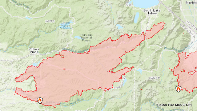
Caldor Burns On, 204,390 Acres, 20% Contained, 729 Structures Destroyed, 4,224 Personnel added by admin on
View all posts by admin →