

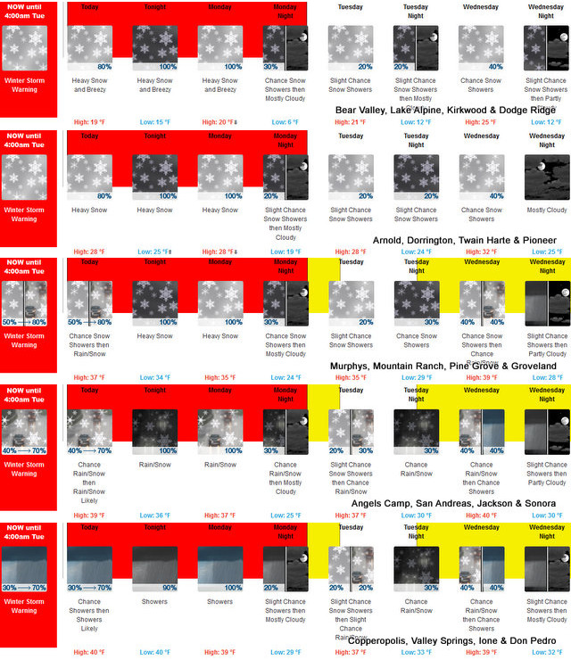
Arnold, CA…The latest from the National Weather Service for our area…Heavy snow occurring. Travel will be very difficult to impossible. Tree branches could fall as well. Additional snow accumulations in the Sierra of 3 to 5 feet, with localized amounts up to 8 feet, are expected above 3000 feet, 6 to 18 inches between 2000 and 3000 feet with localized amounts up to 3 feet, and less than 6 inches below 2000 feet. Additional snow accumulation for the Coastal Range and Shasta County of less than 2 inches below 1500 feet, 4 to 12 inches above 1500 feet, with localized amounts up to 2 feet, are expected.

Winter Storm Warning
URGENT – WINTER WEATHER MESSAGE
National Weather Service Sacramento CA
236 AM PST Sun Dec 26 2021
…Multiple Winter Storms to Impact Mountain and Foothill Travel
through Early This Week…
.Unsettled weather will continue into early this week with
additional mountain snow and gusty winds. We will see another
round of heavy snow later this afternoon into Monday with snow
showers lingering into Monday night. Snow levels will generally be
between 1500 and 2500 feet lowering Monday afternoon into the
evening down to 1000 feet, locally lower over Shasta County and
down to a few 100 feet Monday night.
Major travel delays and difficult to impossible travel conditions
are anticipated through early this week. Gusty winds will further
reduce visibilities during this event with local whiteout
conditions possible. Holiday travelers should prepare for winter
driving conditions by packing chains, warm winter clothes, and
extra food and water. Foothill locations that do not normally
receive snow should prepare for wintry conditions.
CAZ013-014-063-066>069-270000-
/O.CON.KSTO.WS.W.0011.000000T0000Z-211228T1200Z/
Shasta Lake Area / Northern Shasta County-
Burney Basin / Eastern Shasta County-
Mountains Southwestern Shasta County to Western Colusa County-
Northeast Foothills/Sacramento Valley-Motherlode-
Western Plumas County/Lassen Park-
West Slope Northern Sierra Nevada-
Including the cities of Shasta Dam, Burney, Paradise,
and Grass Valley
236 AM PST Sun Dec 26 2021
…WINTER STORM WARNING REMAINS IN EFFECT UNTIL 4 AM PST TUESDAY
ABOVE 1000 FEET…
* WHAT…Heavy snow occurring. Travel will be very difficult to
impossible. Tree branches could fall as well. Additional snow
accumulations in the Sierra of 3 to 5 feet, with localized
amounts up to 8 feet, are expected above 3000 feet, 6 to 18
inches between 2000 and 3000 feet with localized amounts up to
3 feet, and less than 6 inches below 2000 feet. Additional snow
accumulation for the Coastal Range and Shasta County of less
than 2 inches below 1500 feet, 4 to 12 inches above 1500 feet,
with localized amounts up to 2 feet, are expected.
* WHERE…Western Plumas County/Lassen Park and West Slope
Northern Sierra Nevada including Interstate 80 over Donner Pass,
Highway 50 over Echo Summit and Highway 88 over Carson Pass.
Shasta Lake Area / Northern Shasta County, Burney Basin /
Eastern Shasta County and Mountains Southwestern Shasta County
to Western Colusa County including Interstate 5 north of
Redding.
* WHEN…Until 4 AM Tuesday.
* ADDITIONAL DETAILS…Be prepared for significant reductions in
visibility at times.
PRECAUTIONARY/PREPAREDNESS ACTIONS…
A Winter Storm Warning for snow means there will be snow covered
roads and limited visibilities. Travel is not recommended while
the warning is in effect. If you must travel, keep an extra
flashlight, food and water in your vehicle in case of an
emergency.The latest road conditions for the state you are
calling from can be obtained by calling 5 1 1.
$$
Winter Storm Warning, Cold Temps & Up to 8ft of Snow Possible in Some Locations!! added by admin on
View all posts by admin →