

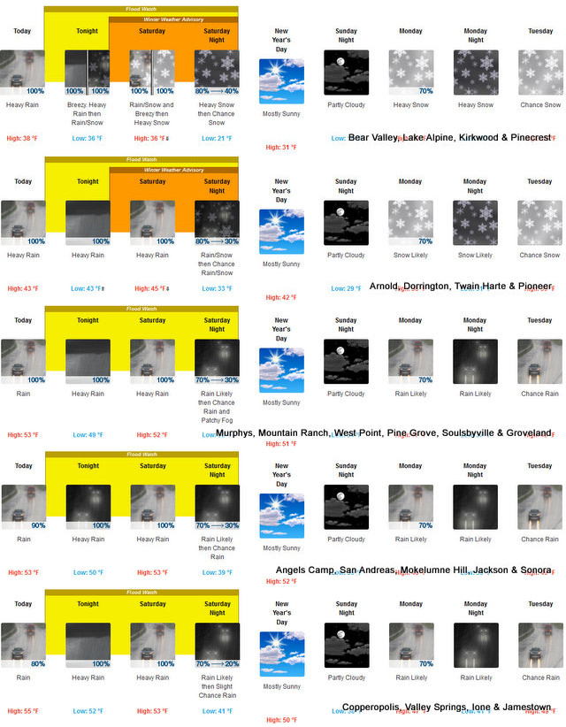
Arnold, CA…The latest Flood Watch & Winter Weather Advisories from the National Weather Service follow…”Heavy rainfall associated an incoming atmospheric river will result in increased potential for areal, small stream, and river flooding across much of northern California. As a result, a Flood Watch remains in effect.

Flood Watch
Flood Watch
National Weather Service Sacramento CA
124 AM PST Fri Dec 30 2022
.Heavy rainfall associated an incoming atmospheric river will result
in increased potential for areal, small stream, and river flooding
across much of northern California. As a result, a Flood Watch
remains in effect.
CAZ068-069-302200-
/O.CON.KSTO.FA.A.0001.221231T0000Z-230101T1200Z/
/00000.0.ER.000000T0000Z.000000T0000Z.000000T0000Z.OO/
Western Plumas County/Lassen Park-West Slope Northern Sierra
Nevada-
Including the cities of Chester, Quincy, and Blue Canyon
124 AM PST Fri Dec 30 2022
…FLOOD WATCH REMAINS IN EFFECT FROM THIS AFTERNOON THROUGH LATE
SATURDAY NIGHT…
* WHAT…Flooding caused by excessive rainfall continues to be
possible.
* WHERE…A portion of northern California, including the following
areas, West Slope Northern Sierra Nevada and Western Plumas
County/Lassen Park.
* WHEN…From this afternoon through late Saturday night.
* IMPACTS…Excessive runoff may result in flooding of rivers,
creeks, streams, and other low-lying and flood-prone locations.
Creeks and streams may rise out of their banks. Flooding may occur
in poor drainage and urban areas. Low-water crossings may be
flooded. Rockslides will be possible. Storm drains and ditches may
become clogged with debris. Extensive street flooding and flooding
of creeks and rivers are possible. Area creeks and streams are
running high and could flood with more heavy rain.
PRECAUTIONARY/PREPAREDNESS ACTIONS…
You should monitor later forecasts and be alert for possible Flood
Warnings. Those living in areas prone to flooding should be prepared
to take action should flooding develop.
&&
$$
Baruffaldi
Winter Weather Advisory
URGENT – WINTER WEATHER MESSAGE
National Weather Service Sacramento CA
131 AM PST Fri Dec 30 2022
CAZ069-302200-
/O.CON.KSTO.WW.Y.0016.221231T1200Z-230101T1200Z/
West Slope Northern Sierra Nevada-
Including the city of Blue Canyon
131 AM PST Fri Dec 30 2022
…WINTER WEATHER ADVISORY REMAINS IN EFFECT FROM 4 AM SATURDAY
TO 4 AM PST SUNDAY…
* WHAT…Snow expected. Total snow accumulations 5 to 12 inches of
snow expected above 6000 ft, locally up to 40 inches above 8000
ft. Winds gusting as high as 55 mph over the higher elevations.
* WHERE…West Slope Northern Sierra Nevada County.
* WHEN…Winter Weather Advisory, from 4 AM Saturday to 4 AM PST
Sunday. Most of the snow will fall from late Saturday afternoon
through Saturday night when snow levels lower below major pass
levels.
* IMPACTS…Travel could be very difficult to impossible. Gusty
winds could bring down tree branches.
PRECAUTIONARY/PREPAREDNESS ACTIONS…
Slow down and use caution while traveling.
The latest road conditions for the state you are calling from can
be obtained by calling 5 1 1.
&&
Heavy Rain, Flood Watch & Up to 40″ of Snow at Higher Elevations New Years Eve added by admin on
View all posts by admin →