

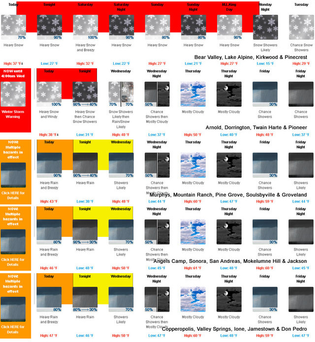
Arnold, CA…Detailed forecast NWS Sacramento for West Slope Northern Sierra Nevada. Today, Mostly cloudy. At lower elevations, a slight chance of rain showers in the morning, then rain showers in the afternoon. At higher elevations, rain showers with heavy snow showers likely in the afternoon. Breezy. Highs 33 to 48 higher elevations… 44 to 54 lower elevations. No snow accumulation lower elevations…2 to 4 inches higher elevations. Snow level 7000 feet. Prevailing south winds 5 to 15 mph increasing to 10 to 25 mph in the afternoon. Gusts up to 40 mph. Over ridges… Prevailing south winds 15 to 30 mph.
Tonight
Rain showers at lower elevations…and heavy rain and snow showers at higher elevations. Colder. Lows 23 to 37 higher elevations…35 to 43 lower elevations. No snow accumulation lower elevations…5 to 10 inches higher elevations. Snow level 6500 feet. Prevailing south winds 10 to 20 mph with gusts to around 35 mph.
Saturday
Rain showers at lower elevations…and heavy rain and snow showers at higher elevations. Windy. Highs 27 to 42 higher elevations…38 to 46 lower elevations. No snow accumulation lower elevations…8 to 13 inches higher elevations. Snow level 6000 feet. Prevailing south winds 15 to 30 mph. Gusts up to 50 mph in the afternoon.
Saturday Night
Heavy rain and snow showers in the evening, then heavy snow showers likely with pockets of showers and thunderstorms after midnight. Breezy, colder. Lows 18 to 33 higher elevations…31 to 39 lower elevations. Snow accumulation up to 1 inch lower elevations…except 9 to 15 inches higher elevations. Snow level 4500 feet. Prevailing southwest winds 15 to 25 mph with gusts to around 45 mph decreasing to 5 to 15 mph with gusts to around 30 mph after midnight.
Sunday
Rain and snow showers. Highs 22 to 37 higher elevations…35 to 43 lower elevations. Snow accumulation 3 to 5 inches. Snow level 4000 feet. Prevailing southwest winds 5 to 15 mph with gusts to around 30 mph.
Sunday Night
Rain and snow showers. Moderate snow accumulations possible. Lows 21 to 36.
Martin Luther King Jr Day
Heavy rain and snow showers. Heavy snow accumulations possible. Highs 26 to 41.
Monday Night
Mostly cloudy with a chance of snow showers. Colder. Lows 17 to 32.
Tuesday
Mostly cloudy with a slight chance of snow showers. Highs 28 to 43.
Tuesday Night
Partly cloudy. Lows 16 to 31.
Wednesday
Mostly cloudy with a slight chance of snow showers. Highs 29 to 44.
Wednesday Night
Mostly cloudy with a chance of rain and snow showers. Lows 18 to 33.
Thursday
Mostly cloudy with a slight chance of snow showers. Highs 30 to 45.
Detailed forecast for
Motherlode
Today
Cloudy. A slight chance of rain showers in the morning, then rain showers in the afternoon. Highs 50 to 60. Prevailing southeast winds 10 to 20 mph.
Tonight
Rain showers and a slight chance of thunderstorms. Lows 40 to 50. Prevailing southeast winds 5 to 15 mph with gusts to around 30 mph.
Saturday
Rain showers. Windy. Highs 44 to 52. Prevailing southeast winds 10 to 20 mph increasing to 15 to 30 mph in the afternoon.
Saturday Night
Rain showers and a slight chance of thunderstorms. Some thunderstorms may produce heavy rainfall. Lows 36 to 44. Prevailing south winds 10 to 20 mph.
Sunday
Rain showers. Highs 40 to 50. Prevailing south winds 5 to 15 mph.
Sunday Night
Rain showers. Lows 36 to 44.
Martin Luther King Jr Day
Rain showers. Highs 40 to 50.
Monday Night
Mostly cloudy with a chance of rain showers. Lows 31 to 39.
Tuesday
Partly cloudy with a slight chance of rain showers. Highs 43 to 53.
Tuesday Night
Partly cloudy. Lows 30 to 38.
Wednesday
Mostly cloudy with a slight chance of rain showers. Highs 43 to 51.
Wednesday Night
Mostly cloudy with a chance of rain showers. Lows 33 to 41.
Thursday
Mostly cloudy. Highs 45 to 53.
Winter Storm Warning
URGENT – WINTER WEATHER MESSAGE
National Weather Service Sacramento CA
300 AM PST Fri Jan 13 2023
CAZ068-069-140000-
/O.CON.KSTO.WS.W.0003.230113T2100Z-230117T0600Z/
Western Plumas County/Lassen Park-
West Slope Northern Sierra Nevada-
Including the cities of Chester, Quincy, and Blue Canyon
300 AM PST Fri Jan 13 2023
…WINTER STORM WARNING REMAINS IN EFFECT FROM 1 PM THIS
AFTERNOON TO 10 PM PST MONDAY…
* WHAT…Heavy snow possible beginning early this afternoon. Total
snow accumulations of 3 to 6 feet possible. Winds could gust as
high as 55 mph.
* WHERE…Western Plumas County/Lassen Park and West Slope
Northern Sierra Nevada including Interstate 80 over Donner
Pass, Highway 50 over Echo Summit and Highway 88 over Carson
Pass.
* WHEN…From 1 PM Friday to 10 PM PST Monday.
* IMPACTS…Travel could be very difficult to impossible. Gusty
winds could bring down tree branches. Widespread blowing snow
could significantly reduce visibility.
* ADDITIONAL DETAILS…Snow will move in early this afternoon
with multiple rounds of heavy snow over the weekend into early
next week. Snow levels will be 5000-6000 feet Friday falling to
3500-4500 feet Saturday night. Mountain travel will be difficult
to impossible especially Saturday and again Monday.
PRECAUTIONARY/PREPAREDNESS ACTIONS…
If you must travel, keep an extra flashlight, food, and water in
your vehicle in case of an emergency.
The latest road conditions for the state you are calling from can
be obtained by calling 5 1 1.
&&
$$
Flood Watch
Flood Watch
National Weather Service Sacramento CA
320 AM PST Fri Jan 13 2023
CAZ015>019-063-066-067-140000-
/O.CON.KSTO.FA.A.0004.230114T1800Z-230115T1500Z/
/00000.0.ER.000000T0000Z.000000T0000Z.000000T0000Z.OO/
Northern Sacramento Valley-Central Sacramento Valley-Southern
Sacramento Valley-Carquinez Strait and Delta-Northern San Joaquin
Valley-Mountains Southwestern Shasta County to Western Colusa
County-Northeast Foothills/Sacramento Valley-Motherlode-
Including the cities of Oroville, Paradise, Sacramento, Stockton,
Grass Valley, Redding, Alder Springs, Marysville/Yuba City,
Jackson, Modesto, Fairfield/Suisun, Red Bluff, and Chico
320 AM PST Fri Jan 13 2023
…FLOOD WATCH REMAINS IN EFFECT FROM SATURDAY MORNING THROUGH
SUNDAY MORNING…
* WHAT…Flooding caused by excessive rainfall continues to be
possible.
* WHERE…A portion of northern California, including the following
areas, Carquinez Strait and Delta, Sacramento Valley, Motherlode,
Mountains of Southwestern Shasta County to Western Colusa County,
Northeast Foothills, Northern San Joaquin Valley.
* WHEN…From Saturday morning through Sunday morning.
* IMPACTS…Excessive runoff may result in flooding of rivers,
creeks, streams, and other low-lying and flood-prone locations.
Creeks and streams may rise out of their banks. Flooding may occur
in poor drainage and urban areas. Low-water crossings may be
flooded.
* ADDITIONAL DETAILS…
– Another round of showers and thunderstorms will bring
moderate to heavy rain across interior NorCal Saturday into
early Sunday, which may lead to urban flooding and rises on
area rivers, creeks and streams.
– http://www.weather.gov/safety/flood
PRECAUTIONARY/PREPAREDNESS ACTIONS…
You should monitor later forecasts and be alert for possible Flood
Warnings. Those living in areas prone to flooding should be prepared
to take action should flooding develop.
&&
$$
kh
Wind Advisory
URGENT – WEATHER MESSAGE
National Weather Service Sacramento CA
119 AM PST Fri Jan 13 2023
CAZ015>019-066-067-140000-
/O.NEW.KSTO.WI.Y.0004.230114T1500Z-230115T0200Z/
Northern Sacramento Valley-Central Sacramento Valley-
Southern Sacramento Valley-Carquinez Strait and Delta-
Northern San Joaquin Valley-Northeast Foothills/Sacramento Valley-
Motherlode-
Including the cities of Redding, Red Bluff, Chico, Oroville,
Marysville/Yuba City, Sacramento, Fairfield/Suisun, Stockton,
Modesto, Paradise, Grass Valley, and Jackson
119 AM PST Fri Jan 13 2023
…WIND ADVISORY IN EFFECT FROM 7 AM TO 6 PM PST SATURDAY…
* WHAT…South winds 15 to 25 mph with gusts 35 to 55 mph
expected.
* WHERE…Sacramento Valley, Carquinez Strait and Delta, Northern
San Joaquin Valley, Northeast Foothills and Motherlode
Counties.
* WHEN…From 7 AM to 6 PM PST Saturday.
* IMPACTS…Gusty winds could blow around unsecured objects.
Tree limbs could be blown down and a few power outages may
result.
* ADDITIONAL DETAILS…Saturated soils will allow for trees to
topple more easily during these winds.
PRECAUTIONARY/PREPAREDNESS ACTIONS…
Use extra caution when driving, especially if operating a high
profile vehicle. Secure outdoor objects.
&&
$$
Another Wave of Moisture Breaking Our Way This Weekend. Full Forecasts & Warnings Below! added by admin on
View all posts by admin →