

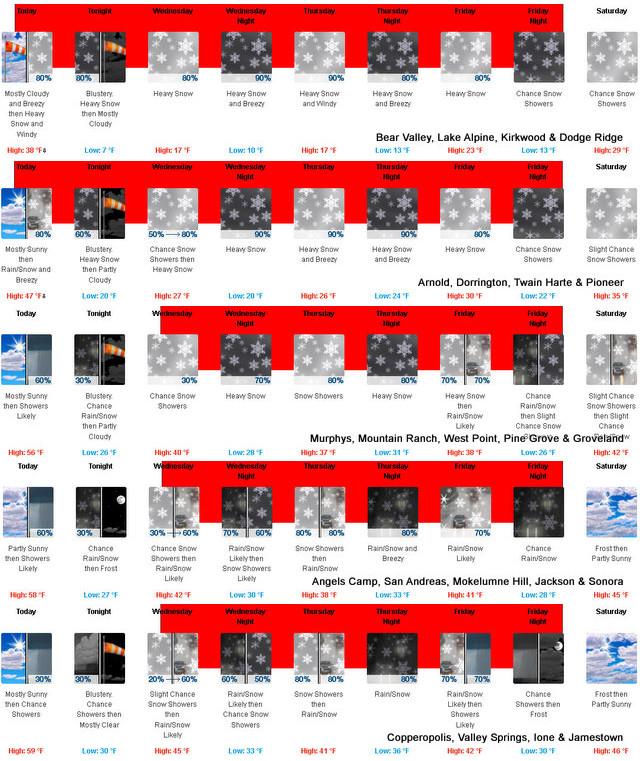
Arnold, CA…So you thought that Mother Nature was done with us for this winter? Well, Well…think again. This batch of systems are forecasted to bring snow down to the lowest elevations of the year. Heavy snow expected. Total snow accumulations of 1 to 3 feet, with locally higher amounts. Winds gusting as high as 70 mph.
Winter Storm Warning
URGENT – WINTER WEATHER MESSAGE
National Weather Service Sacramento CA
742 AM PST Tue Feb 21 2023
CAZ068-069-221500-
/O.CON.KSTO.WS.W.0006.230221T1800Z-230225T1200Z/
Western Plumas County/Lassen Park-
West Slope Northern Sierra Nevada-
Including the cities of Chester, Quincy, and Blue Canyon
742 AM PST Tue Feb 21 2023
…WINTER STORM WARNING REMAINS IN EFFECT UNTIL 4 AM PST
SATURDAY…
* WHAT…Heavy snow expected. Total snow accumulations of 1 to 3
feet, with locally higher amounts. Winds gusting as high as 70
mph.
* WHERE…Western Plumas County/Lassen Park and West Slope
Northern Sierra Nevada Counties.
* WHEN…From 10 AM this morning to 4 AM PST Saturday.
* IMPACTS…Travel could be very difficult to impossible. The
hazardous conditions could impact the morning or evening
commute. Very strong winds could cause extensive tree damage.
* ADDITIONAL DETAILS…Snow levels 4000-5000 feet Today, lowering
to 1000-2000 tonight through Friday, locally lower. Lighter
snow is forecast late tonight into Wednesday morning. Heaviest
snow expected Wednesday afternoon through Friday morning.
PRECAUTIONARY/PREPAREDNESS ACTIONS…
If you must travel, keep an extra flashlight, food, and water in
your vehicle in case of an emergency.
The latest road conditions for the state you are calling from can
be obtained by calling 5 1 1.
weather.gov
National Weather Service
Watches, Warnings & Advisories
Go to the NOAA Homepage
NWS Homepage
Local weather forecast by “City, St” or zip code
One product issued by NWS for: Angels CA
Share
|
Winter Storm Warning
URGENT – WINTER WEATHER MESSAGE
National Weather Service Sacramento CA
742 AM PST Tue Feb 21 2023
CAZ066-067-221500-
/O.CON.KSTO.WS.W.0006.230222T1800Z-230225T1200Z/
Northeast Foothills/Sacramento Valley-Motherlode-
Including the cities of Paradise, Grass Valley, and Jackson
742 AM PST Tue Feb 21 2023
…WINTER STORM WARNING REMAINS IN EFFECT FROM 10 AM WEDNESDAY TO
4 AM PST SATURDAY…
* WHAT…Heavy snow expected. Total snow accumulations of 2 to 8
inches between 1000 to 1500 feet, and 1 to 2 feet between 1500
and 3000 feet. Winds gusting as high as 40 mph.
* WHERE…Northeast Foothills/Sacramento Valley and the Motherlode.
* WHEN…From 10 AM Wednesday to 4 AM PST Saturday.
* IMPACTS…Travel could be very difficult to impossible. The
hazardous conditions could impact the morning or evening
commute.
* ADDITIONAL DETAILS…Snow levels 4000-5000 feet Today,
lowering to 1000-2000 tonight through Friday, locally lower.
Heaviest snow expected Wednesday afternoon through Friday
morning.
PRECAUTIONARY/PREPAREDNESS ACTIONS…
If you must travel, keep an extra flashlight, food, and water in
your vehicle in case of an emergency.
The latest road conditions for the state you are calling from can
be obtained by calling 5 1 1.
&&
$$
U.S. Dept. of Commerce
NOAA National Weather Service
1325 East West Highway
Silver Spring, MD 20910
E-mail: w-nws.webmaster@noaa.gov
Page last modified: May 16, 2007
Disclaimer
Credits
Glossary
Privacy Policy
About Us
Career Opportunities
NATIONAL WEATHER SERVICE: for Safety, for Work, for Fun – FOR LIFE
Winter Storm Warning with Snow Down to 1,000 Feet Through Saturday added by admin on
View all posts by admin →