

Arnold, CA…Ladies, Gents, Boys & Girls, Mother Nature is back for another round the next few days. She will be throwing pretty much everything including possibly a kitchen sink or two. Up to 96 Inches of snow at the highest elevations with wind gust as high as 80 mph. At lower elevations we could see 5-7 inches of rain with the accompanying flooding in low lying areas as well. Buckle up and here we go…
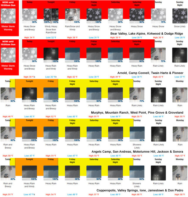
Winter Storm Warning
URGENT – WINTER WEATHER MESSAGE
National Weather Service Sacramento CA
205 AM PST Thu Mar 9 2023
CAZ068-069-100000-
/O.CON.KSTO.WS.W.0009.230309T1800Z-230312T1700Z/
Western Plumas County/Lassen Park-
West Slope Northern Sierra Nevada-
Including the cities of Chester, Quincy, and Blue Canyon
205 AM PST Thu Mar 9 2023
…WINTER STORM WARNING REMAINS IN EFFECT FROM 10 AM PST THURSDAY
TO 10 AM PDT SUNDAY…
* WHAT…Heavy snow expected. Total snow accumulations of up to
96 inches. Winds gusting as high as 80 mph.
* WHERE…Western Plumas County/Lassen Park and West Slope
Northern Sierra Nevada including Interstate 80 over Donner Pass
and Highway 50 over Echo Summit.
* WHEN…From 10 AM PST Thursday to 10 AM PDT Sunday.
* IMPACTS…Travel could be very difficult to impossible. Blowing
snow could significantly reduce visibility. Very strong winds
could cause extensive tree damage.
PRECAUTIONARY/PREPAREDNESS ACTIONS…
If you must travel, keep an extra flashlight, food, and water in
your vehicle in case of an emergency.
The latest road conditions for the state you are calling from can
be obtained by calling 5 1 1.
&&
$$
Flood Watch
Flood Watch
National Weather Service Sacramento CA
642 AM PST Thu Mar 9 2023
CAZ013>019-063-066>069-101500-
/O.CON.KSTO.FA.A.0005.230309T2100Z-230312T1700Z/
/00000.0.ER.000000T0000Z.000000T0000Z.000000T0000Z.OO/
Shasta Lake Area / Northern Shasta County-Burney Basin / Eastern
Shasta County-Northern Sacramento Valley-Central Sacramento
Valley-Southern Sacramento Valley-Carquinez Strait and Delta-
Northern San Joaquin Valley-Mountains Southwestern Shasta County
to Western Colusa County-Northeast Foothills/Sacramento Valley-
Motherlode-Western Plumas County/Lassen Park-West Slope Northern
Sierra Nevada-
Including the cities of Blue Canyon, Modesto, Sacramento,
Chester, Quincy, Oroville, Fairfield/Suisun, Shasta Dam, Burney,
Grass Valley, Redding, Alder Springs, Paradise, Red Bluff,
Stockton, Jackson, Chico, and Marysville/Yuba City
642 AM PST Thu Mar 9 2023
…FLOOD WATCH REMAINS IN EFFECT THIS AFTERNOON THROUGH SUNDAY
MORNING FOR ELEVATIONS BELOW 4000 FEET…
* WHAT…Flooding caused by excessive rainfall and snow melt is
possible.
* WHERE…A portion of northern California, including the following
areas, Burney Basin / Eastern Shasta County, Carquinez Strait and
Delta, Central Sacramento Valley, Motherlode, Mountains
Southwestern Shasta County to Western Colusa County, Northeast
Foothills/Sacramento Valley, Northern Sacramento Valley, Northern
San Joaquin Valley, Shasta Lake Area / Northern Shasta County,
Southern Sacramento Valley, West Slope Northern Sierra Nevada and
Western Plumas County/Lassen Park.
* WHEN…From this afternoon through Sunday morning. Heaviest rain
expected tonight into Friday.
* IMPACTS…Excessive runoff may result in flooding of rivers,
creeks, streams, and other low-lying and flood-prone locations.
Creeks and streams may rise out of their banks. Flooding may occur
in poor drainage and urban areas.
* ADDITIONAL DETAILS…
– http://www.weather.gov/safety/flood
PRECAUTIONARY/PREPAREDNESS ACTIONS…
You should monitor later forecasts and be alert for possible Flood
Warnings. Those living in areas prone to flooding should be prepared
to take action should flooding develop.
&&
$$
KH
Wind Advisory
URGENT – WEATHER MESSAGE
National Weather Service Sacramento CA
205 AM PST Thu Mar 9 2023
CAZ015>019-063-066>069-100000-
/O.CON.KSTO.WI.Y.0012.230310T0000Z-230311T0000Z/
Northern Sacramento Valley-Central Sacramento Valley-
Southern Sacramento Valley-Carquinez Strait and Delta-
Northern San Joaquin Valley-
Mountains Southwestern Shasta County to Western Colusa County-
Northeast Foothills/Sacramento Valley-Motherlode-
Western Plumas County/Lassen Park-
West Slope Northern Sierra Nevada-
Including the cities of Redding, Red Bluff, Chico, Oroville,
Marysville/Yuba City, Sacramento, Fairfield/Suisun, Stockton,
Modesto, Alder Springs, Paradise, Grass Valley, Jackson, Chester,
Quincy, and Blue Canyon
205 AM PST Thu Mar 9 2023
…WIND ADVISORY REMAINS IN EFFECT FROM 4 PM THURSDAY TO 4 PM PST
FRIDAY…
* WHAT…South winds 25 to 35 mph with gusts of 45 to 55 mph in
the Central Valley, and gusts of 50 to 70 mph in the foothills
and mountains.
* WHERE…Sacramento Valley, Carquinez Strait and Delta, Northern
San Joaquin Valley, Mountains Southwestern Shasta County to
Western Colusa County, Northeast Foothills/Sacramento Valley,
Motherlode, Western Plumas County/Lassen Park and West Slope
Northern Sierra Nevada.
* WHEN…From 4 PM Thursday to 4 PM PST Friday.
* IMPACTS…Gusty winds could blow around unsecured objects.
Tree limbs could be blown down and a few power outages may
result.
PRECAUTIONARY/PREPAREDNESS ACTIONS…
Use extra caution when driving, especially if operating a high
profile vehicle. Secure outdoor objects.
&&
Mother Nature is Back with a Vengeance with Snow, Wind, Rain & Floods added by admin on
View all posts by admin →