


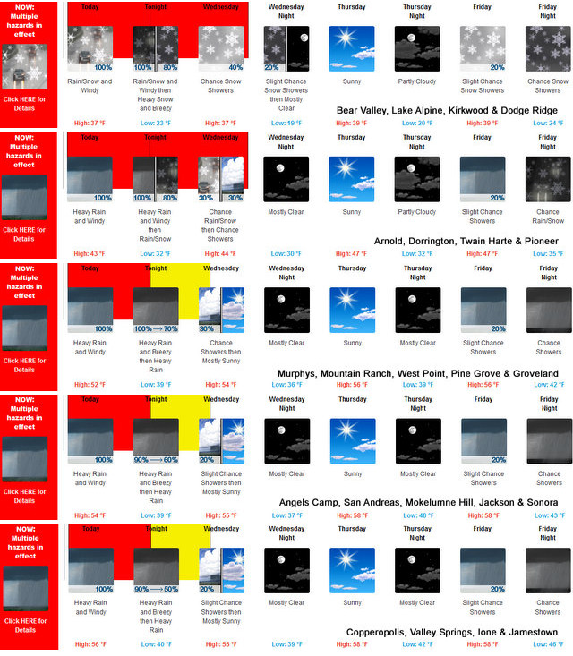
Arnold, CA…Heavy snow. Additional snow accumulations of 1 to 3 feet above 6500 feet, up to 5 feet above 8000 feet. Winds gusting as high as 75 mph. Flooding caused by excessive rainfall continues to be possible. Details for the West Slope & Mother Lode areas are below…

* WHERE…Western Plumas County/Lassen Park and West Slope
Northern Sierra Nevada including Interstate 80 over Donner
Pass and Highway 50 over Echo Summit.
Winter Storm Warning
URGENT – WINTER WEATHER MESSAGE
National Weather Service Sacramento CA
230 AM PDT Tue Mar 14 2023
CAZ068-069-150000-
/O.CON.KSTO.WS.W.0009.000000T0000Z-230316T0000Z/
Western Plumas County/Lassen Park-
West Slope Northern Sierra Nevada-
Including the cities of Chester, Quincy, and Blue Canyon
230 AM PDT Tue Mar 14 2023
…WINTER STORM WARNING REMAINS IN EFFECT UNTIL 5 PM PDT
WEDNESDAY…
* WHAT…Heavy snow. Additional snow accumulations of 1 to 3 feet
above 6500 feet, up to 5 feet above 8000 feet. Winds gusting as
high as 75 mph.
* WHERE…Western Plumas County/Lassen Park and West Slope
Northern Sierra Nevada including Interstate 80 over Donner
Pass and Highway 50 over Echo Summit.
* WHEN…Until 5 PM PDT Wednesday.
* IMPACTS…Travel could be very difficult to impossible.
Reduced visibility at times due to heavy snow. Very strong
winds could cause extensive tree damage.
* ADDITIONAL DETAILS…Snow levels rising to 7500 to 8500 feet
today, lowering to 4000 to 6000 ft tonight, and to 3000 to 5000
feet by Wednesday morning.
PRECAUTIONARY/PREPAREDNESS ACTIONS…
If you must travel, keep an extra flashlight, food, and water in
your vehicle in case of an emergency.
The latest road conditions for the state you are calling from can
be obtained by calling 5 1 1.
&&
$$
High Wind Warning
URGENT – WEATHER MESSAGE
National Weather Service Sacramento CA
230 AM PDT Tue Mar 14 2023
CAZ013-015>019-063-066>069-150000-
/O.CON.KSTO.HW.W.0003.230314T1200Z-230315T0600Z/
Shasta Lake Area / Northern Shasta County-
Northern Sacramento Valley-Central Sacramento Valley-
Southern Sacramento Valley-Carquinez Strait and Delta-
Northern San Joaquin Valley-
Mountains Southwestern Shasta County to Western Colusa County-
Northeast Foothills/Sacramento Valley-Motherlode-
Western Plumas County/Lassen Park-
West Slope Northern Sierra Nevada-
Including the cities of Shasta Dam, Redding, Red Bluff, Chico,
Oroville, Marysville/Yuba City, Sacramento, Fairfield/Suisun,
Stockton, Modesto, Alder Springs, Paradise, Grass Valley,
Jackson, Chester, Quincy, and Blue Canyon
230 AM PDT Tue Mar 14 2023
…HIGH WIND WARNING REMAINS IN EFFECT FROM 5 AM UNTIL 11 PM PDT
THIS EVENING…
* WHAT…South winds 25 to 35 mph with gusts of 50 to 60 mph.
Local gusts up to 70 mph expected.
* WHERE…Portions of northern California including the Sacramento
Valley, Carquinez Strait and Delta, northern San Joaquin Valley
and adjacent foothills and mountains.
* WHEN…Until 11 PM PDT this evening.
* IMPACTS…Damaging winds will blow down trees and power lines.
Saturated soils could lead to additional downed trees.
Widespread power outages are expected. Travel will be
difficult, especially for high profile vehicles.
* ADDITIONAL DETAILS…The strongest winds are expected to develop
this morning and continue into this evening.
PRECAUTIONARY/PREPAREDNESS ACTIONS…
People should avoid being outside in forested areas and around
trees and branches. If possible, remain in the lower levels of
your home during the windstorm, and avoid windows. Use caution if
you must drive.
&&
$$
Flood Watch
Flood Watch
National Weather Service Sacramento CA
430 PM PDT Mon Mar 13 2023
CAZ013>019-063-066>069-150000-
/O.CON.KSTO.FA.A.0006.000000T0000Z-230315T1700Z/
/00000.0.ER.000000T0000Z.000000T0000Z.000000T0000Z.OO/
Shasta Lake Area / Northern Shasta County-Burney Basin / Eastern
Shasta County-Northern Sacramento Valley-Central Sacramento
Valley-Southern Sacramento Valley-Carquinez Strait and Delta-
Northern San Joaquin Valley-Mountains Southwestern Shasta County
to Western Colusa County-Northeast Foothills/Sacramento Valley-
Motherlode-Western Plumas County/Lassen Park-West Slope Northern
Sierra Nevada-
Including the cities of Red Bluff, Stockton, Sacramento, Shasta
Dam, Oroville, Modesto, Grass Valley, Redding, Fairfield/Suisun,
Burney, Alder Springs, Marysville/Yuba City, Paradise, Blue
Canyon, Chester, Jackson, Chico, and Quincy
430 PM PDT Mon Mar 13 2023
…FLOOD WATCH REMAINS IN EFFECT THROUGH WEDNESDAY MORNING…
* WHAT…Flooding caused by excessive rainfall continues to be
possible.
* WHERE…A portion of northern California, including the following
areas, Burney Basin / Eastern Shasta County, Carquinez Strait and
Delta, Central Sacramento Valley, Motherlode, Mountains
Southwestern Shasta County to Western Colusa County, Northeast
Foothills/Sacramento Valley, Northern Sacramento Valley, Northern
San Joaquin Valley, Shasta Lake Area / Northern Shasta County,
Southern Sacramento Valley, West Slope Northern Sierra Nevada and
Western Plumas County/Lassen Park.
* WHEN…Through Wednesday morning.
* IMPACTS…Excessive runoff may result in flooding of rivers,
creeks, streams, and other low-lying and flood-prone locations.
Creeks and streams may rise out of their banks. Flooding may occur
in poor drainage and urban areas.
* ADDITIONAL DETAILS…
– http://www.weather.gov/safety/flood
PRECAUTIONARY/PREPAREDNESS ACTIONS…
You should monitor later forecasts and be alert for possible Flood
Warnings. Those living in areas prone to flooding should be prepared
to take action should flooding develop.
&&
$$
EK
Flood Advisory
Flood Advisory
National Weather Service Reno NV
125 PM PDT Mon Mar 13 2023
CAC003-017-035-051-057-061-063-091-NVC001-005-019-021-029-031-510-
142030-
/O.NEW.KREV.FA.Y.0005.230313T2025Z-230315T0600Z/
/00000.N.ER.000000T0000Z.000000T0000Z.000000T0000Z.OO/
Alpine CA-El Dorado CA-Lassen CA-Mono CA-Nevada CA-Placer CA-Plumas
CA-Sierra CA-Churchill NV-Douglas NV-Lyon NV-Mineral NV-Storey NV-
Washoe NV-Carson City NV-
125 PM PDT Mon Mar 13 2023
…FLOOD ADVISORY IN EFFECT UNTIL 11 PM PDT TUESDAY…
* WHAT…Flooding caused by excessive rainfall and snow melt is
expected.
* WHERE…Portions of California and Nevada, including the following
counties and independent city, in California, Alpine, El Dorado,
Lassen, Mono, Nevada, Placer, Plumas and Sierra. In Nevada, Carson
City, Churchill, Douglas, Lyon, Mineral, Storey and Washoe.
* WHEN…Until 1100 PM PDT Tuesday.
* IMPACTS…Excessive runoff may result in flooding of rivers,
creeks, streams and other low-lying and poor drainage areas.
Flooding may occur in mountain urban areas due to deep snow
confining flow and restricting drainage. Runoff exceeding drainage
capacity is expected to impact roads, agricultural areas, and poor
drainage areas. Very high flows will continue on the Carson River
both above and below Lahontan Reservoir and on the Walker River.
Terminal Lakes will see additional rises.
* ADDITIONAL DETAILS…
– At 117 PM PDT, Heavy rain with snow levels above 7000 feet
are expected to renew the risk of flooding Tuesday morning
through Wednesday, mostly in areas below approximately 7000
feet. Areas of primary concern are small creeks and streams,
and areas with poor or obstructed drainage, including areas
impacted by flooding recently. This includes the Walker
River, where minor lowland flooding is currently ongoing
below Yerington. Very High flows are also ongoing along the
Carson river. Additional river flooding is a concern,
especially on the East Fork and mainstem of the Walker, the
Carson River, and the Middle Fork of the Feather near
Portola.
– A warm atmospheric river will lead to rapid runoff in
elevations below approximately 7000 feet. Although this
atmospheric river appears to be slightly cooler and maybe not
quite as wet as last Friday`s storm, runoff will respond more
rapidly due to primed low elevation snowpack, current high
river and stream flows, and saturated ground conditions.
Expect renewed flooding in areas that have just experienced
flood impacts. Significant river rises are expected with
river flooding possible on the Middle Fork of the Feather,
and segments of the Carson and Walker Rivers.
– http://www.weather.gov/safety/flood
PRECAUTIONARY/PREPAREDNESS ACTIONS…
Turn around, don`t drown when encountering flooded roads. Most flood
deaths occur in vehicles.
&&
LAT…LON 4118 12133 4118 12000 4199 12000 4199 11932
4000 11934 3992 11747 3909 11778 3900 11820
3847 11769 3790 11843 3747 11783 3748 11885
3772 11926 3805 11931 3885 12015 3962 12048
3971 12072 4020 12089 4019 12089 4059 12132
2 products issued by NWS for: 8 Miles SW Angels CA
Share
|
High Wind Warning
URGENT – WEATHER MESSAGE
National Weather Service Sacramento CA
230 AM PDT Tue Mar 14 2023
CAZ013-015>019-063-066>069-150000-
/O.CON.KSTO.HW.W.0003.230314T1200Z-230315T0600Z/
Shasta Lake Area / Northern Shasta County-
Northern Sacramento Valley-Central Sacramento Valley-
Southern Sacramento Valley-Carquinez Strait and Delta-
Northern San Joaquin Valley-
Mountains Southwestern Shasta County to Western Colusa County-
Northeast Foothills/Sacramento Valley-Motherlode-
Western Plumas County/Lassen Park-
West Slope Northern Sierra Nevada-
Including the cities of Shasta Dam, Redding, Red Bluff, Chico,
Oroville, Marysville/Yuba City, Sacramento, Fairfield/Suisun,
Stockton, Modesto, Alder Springs, Paradise, Grass Valley,
Jackson, Chester, Quincy, and Blue Canyon
230 AM PDT Tue Mar 14 2023
…HIGH WIND WARNING REMAINS IN EFFECT FROM 5 AM UNTIL 11 PM PDT
THIS EVENING…
* WHAT…South winds 25 to 35 mph with gusts of 50 to 60 mph.
Local gusts up to 70 mph expected.
* WHERE…Portions of northern California including the Sacramento
Valley, Carquinez Strait and Delta, northern San Joaquin Valley
and adjacent foothills and mountains.
* WHEN…Until 11 PM PDT this evening.
* IMPACTS…Damaging winds will blow down trees and power lines.
Saturated soils could lead to additional downed trees.
Widespread power outages are expected. Travel will be
difficult, especially for high profile vehicles.
* ADDITIONAL DETAILS…The strongest winds are expected to develop
this morning and continue into this evening.
PRECAUTIONARY/PREPAREDNESS ACTIONS…
People should avoid being outside in forested areas and around
trees and branches. If possible, remain in the lower levels of
your home during the windstorm, and avoid windows. Use caution if
you must drive.
&&
$$
Flood Watch
Flood Watch
National Weather Service Sacramento CA
430 PM PDT Mon Mar 13 2023
CAZ013>019-063-066>069-150000-
/O.CON.KSTO.FA.A.0006.000000T0000Z-230315T1700Z/
/00000.0.ER.000000T0000Z.000000T0000Z.000000T0000Z.OO/
Shasta Lake Area / Northern Shasta County-Burney Basin / Eastern
Shasta County-Northern Sacramento Valley-Central Sacramento
Valley-Southern Sacramento Valley-Carquinez Strait and Delta-
Northern San Joaquin Valley-Mountains Southwestern Shasta County
to Western Colusa County-Northeast Foothills/Sacramento Valley-
Motherlode-Western Plumas County/Lassen Park-West Slope Northern
Sierra Nevada-
Including the cities of Red Bluff, Stockton, Sacramento, Shasta
Dam, Oroville, Modesto, Grass Valley, Redding, Fairfield/Suisun,
Burney, Alder Springs, Marysville/Yuba City, Paradise, Blue
Canyon, Chester, Jackson, Chico, and Quincy
430 PM PDT Mon Mar 13 2023
…FLOOD WATCH REMAINS IN EFFECT THROUGH WEDNESDAY MORNING…
* WHAT…Flooding caused by excessive rainfall continues to be
possible.
* WHERE…A portion of northern California, including the following
areas, Burney Basin / Eastern Shasta County, Carquinez Strait and
Delta, Central Sacramento Valley, Motherlode, Mountains
Southwestern Shasta County to Western Colusa County, Northeast
Foothills/Sacramento Valley, Northern Sacramento Valley, Northern
San Joaquin Valley, Shasta Lake Area / Northern Shasta County,
Southern Sacramento Valley, West Slope Northern Sierra Nevada and
Western Plumas County/Lassen Park.
* WHEN…Through Wednesday morning.
* IMPACTS…Excessive runoff may result in flooding of rivers,
creeks, streams, and other low-lying and flood-prone locations.
Creeks and streams may rise out of their banks. Flooding may occur
in poor drainage and urban areas.
* ADDITIONAL DETAILS…
– http://www.weather.gov/safety/flood
PRECAUTIONARY/PREPAREDNESS ACTIONS…
You should monitor later forecasts and be alert for possible Flood
Warnings. Those living in areas prone to flooding should be prepared
to take action should flooding develop.
Winter Storm Warnings, Flood Watches, High Wind Warnings & More! added by admin on
View all posts by admin →