

Arnold, CA…The National Weather Service in Sacramento is forecasting for our balmy temps to ebb, cooler temps to make an appearance with rain possible by Saturday Evening. Full forecasts for the West Slope & Motherlode are below…

Detailed forecast for
West Slope Northern Sierra Nevada
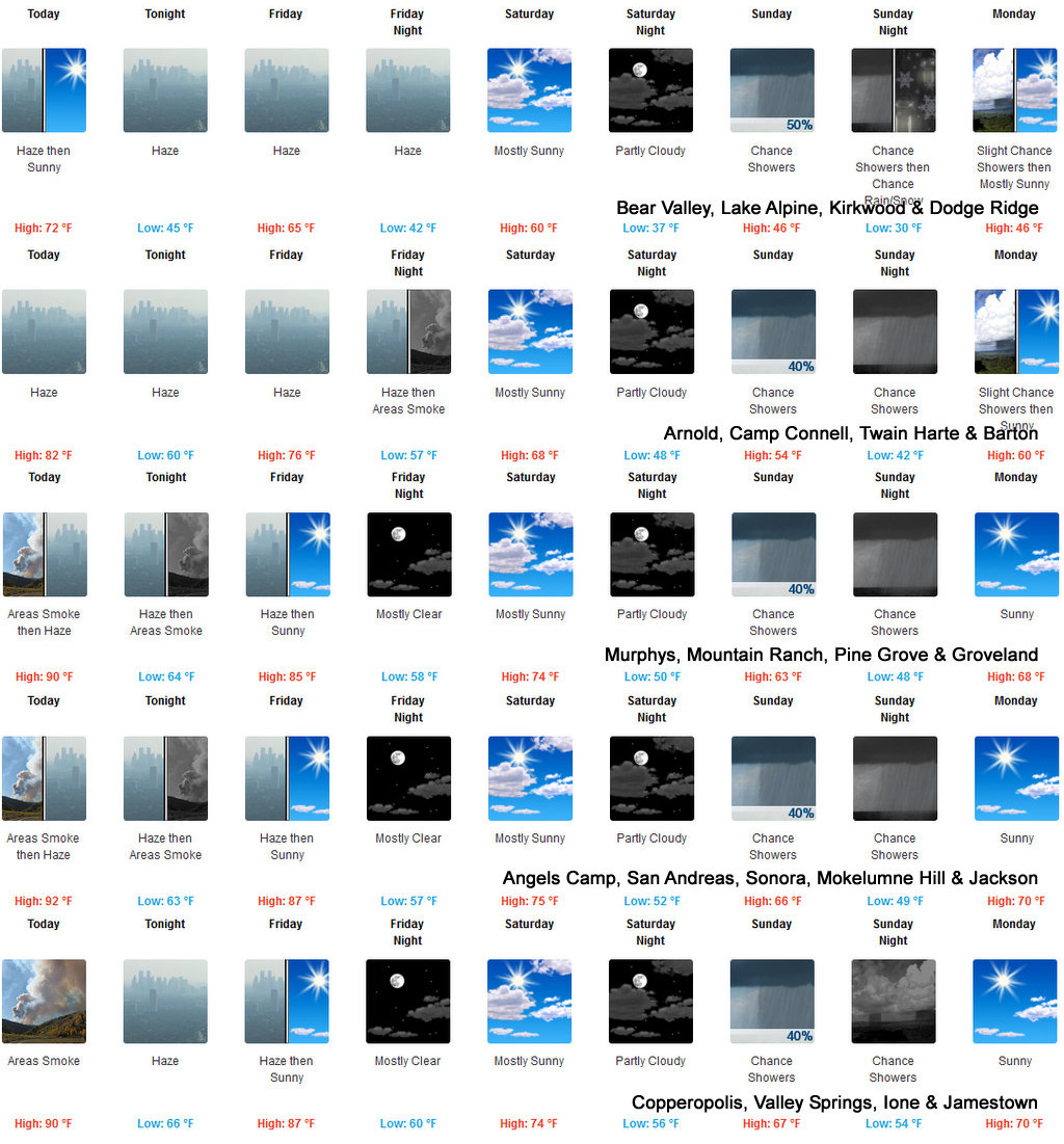
Today
Sunny. Areas of smoke early in the morning. Haze through the day. Highs 67 to 82 higher elevations…81 to 91 lower elevations. Prevailing east winds up to 10 mph shifting to the west in the afternoon.
Tonight
Clear. Haze and areas of smoke. Lows 44 to 59 higher elevations…54 to 68 lower elevations. Prevailing north winds up to 10 mph shifting to the east after midnight.
Friday
Mostly sunny. Haze. Highs 62 to 77 higher elevations… 75 to 85 lower elevations. Prevailing east winds up to 10 mph shifting to the southwest in the afternoon.
Friday Night
Clear, colder. Lows 40 to 55 higher elevations… 49 to 63 lower elevations. Prevailing southwest winds up to 10 mph shifting to the east after midnight.
Saturday
Mostly sunny in the morning then becoming partly cloudy. Highs 55 to 70 higher elevations…66 to 76 lower elevations. Prevailing east winds up to 10 mph shifting to the southwest in the afternoon.
Saturday Night
Partly cloudy. Colder. Lows 36 to 51.
Sunday
Mostly cloudy with a chance of rain showers. Highs 44 to 59.
Sunday Night
Mostly cloudy with a chance of rain showers. Colder. Lows 31 to 46.
Monday
Partly cloudy with a slight chance of rain showers. Not as cool. Highs 49 to 64.
Monday Night
Mostly clear. Lows 33 to 48.
Tuesday
Partly cloudy with a slight chance of rain showers. Warmer. Highs 52 to 67.
Tuesday Night And Wednesday
Mostly cloudy with a chance of rain and snow showers. Lows 32 to 47. Highs 49 to 64.
Detailed forecast for
Motherlode
Today
Sunny. Areas of smoke until late afternoon. Haze through the day. Highs 86 to 94. Prevailing east winds up to 10 mph shifting to the west in the afternoon.
Tonight
Clear. Haze through the night. Areas of smoke after midnight. Lows 58 to 68. Prevailing north winds up to 10 mph shifting to the east after midnight.
Friday
Haze and areas of smoke in the morning. Mostly sunny. Highs 81 to 89. Prevailing east winds up to 10 mph shifting to the southwest in the afternoon.
Friday Night
Clear, cooler. Lows 53 to 61. Prevailing west winds up to 10 mph in the evening becoming light.
Saturday
Partly cloudy. Highs 67 to 77. Light winds becoming southwest up to 10 mph in the afternoon.
Saturday Night
Partly cloudy with a slight chance of rain showers. Lows 48 to 56.
Sunday
Mostly cloudy with a chance of rain showers. Highs 57 to 69.
Sunday Night
Mostly cloudy with a chance of rain showers. Lows 44 to 52.
Monday And Monday Night
Mostly clear. Highs 65 to 75. Lows 44 to 54.
Tuesday
Partly cloudy with a slight chance of rain showers. Highs 64 to 74.
Tuesday Night And Wednesday
Partly cloudy with a slight chance of rain showers. Lows 46 to 54. Highs 60 to 74.
Fall Temps Will Be Falling & Chance of Rain Sunday! added by admin on
View all posts by admin →