

Arnold, CA…Make sure you hold your honey tight the next few days as the National Weather Service says some locations will see gusts up to 80 mph. The winds may be strong enough to down trees etc so power outages can be expected.

Detailed forecast for
West Slope Northern Sierra Nevada
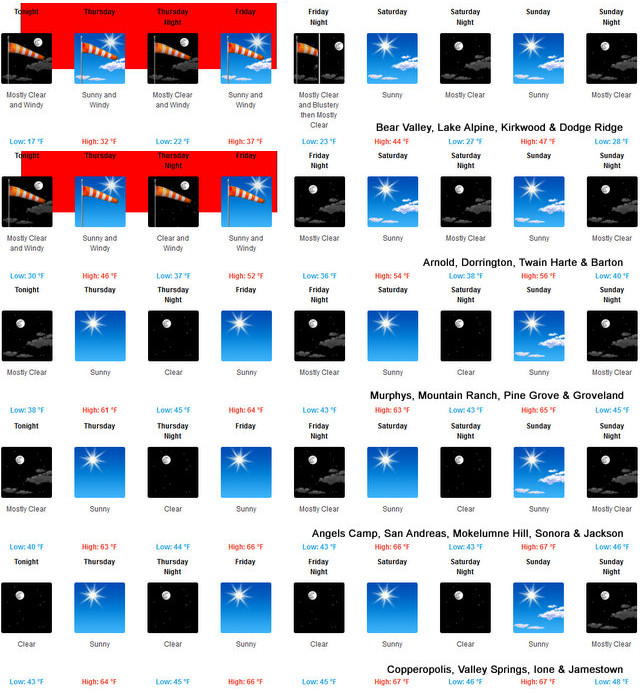
Today
Mostly sunny. Not as cool. Highs 33 to 48 higher elevations…46 to 58 lower elevations. Prevailing northeast winds up to 15 mph.
Tonight
Mostly clear. Very windy. Lows 14 to 29 higher elevations…28 to 38 lower elevations. Prevailing northeast winds 15 to 25 mph with gusts to around 55 mph increasing to 30 to 45 mph with gusts to around 75 mph after midnight. Over ridges, prevailing northeast winds 30 to 40 mph increasing to 45 to 65 mph after midnight.
Thursday
Sunny. Strong winds. Highs 30 to 45 higher elevations…46 to 58 lower elevations. Prevailing northeast winds 35 to 55 mph decreasing to 25 to 45 mph in the afternoon. Gusts up to 75 mph. Over ridges…prevailing northeast winds 45 to 65 mph.
Thursday Night
Clear. Very windy. Lows 20 to 35 higher elevations…35 to 45 lower elevations. Prevailing northeast winds 25 to 45 mph with gusts to around 65 mph…except northeast 25 to 55 mph over ridges.
Friday
Sunny. Very windy. Not as cool. Highs 35 to 50 higher elevations…51 to 63 lower elevations. Prevailing northeast winds 25 to 45 mph decreasing to 25 to 35 mph in the afternoon. Gusts up to 65 mph. Over ridges…prevailing northeast winds 30 to 50 mph.
Friday Night
Clear. Lows 24 to 39.
Saturday
Sunny. Not as cool. Highs 45 to 60.
Saturday Night
Clear. Lows 27 to 42.
Sunday
Mostly sunny. Not as cool. Highs 48 to 63.
Sunday Night And Monday
Clear. Lows 29 to 44. Highs 49 to 64.
Monday Night
Mostly clear. Lows 30 to 45.
Tuesday
Partly cloudy with a slight chance of rain showers. Highs 48 to 63.
High Wind Warning
URGENT – WEATHER MESSAGE
National Weather Service Sacramento CA
157 PM PDT Wed Mar 13 2024
CAZ068-069-141200-
/O.CON.KSTO.HW.W.0002.240314T0600Z-240316T0000Z/
Western Plumas County/Lassen Park-
West Slope Northern Sierra Nevada-
Including the cities of Chester, Quincy, and Blue Canyon
157 PM PDT Wed Mar 13 2024
…HIGH WIND WARNING REMAINS IN EFFECT FROM 11 PM THIS EVENING TO
5 PM PDT FRIDAY…
* WHAT…Northeast winds 40 to 55 mph with gusts up to 80 mph
possible. Strongest winds above 4000 feet.
* WHERE…Western Plumas County/Lassen Park and West Slope
Northern Sierra Nevada Counties.
* WHEN…From 11 PM this evening to 5 PM PDT Friday.
* IMPACTS…Damaging winds will blow down trees and power lines.
Widespread power outages are expected. Travel will be
difficult, especially for high profile vehicles.
PRECAUTIONARY/PREPAREDNESS ACTIONS…
People should avoid being outside in forested areas and around
trees and branches. If possible, remain in the lower levels of
your home during the windstorm, and avoid windows. Use caution if
you must drive.
&&
$$
Blustery Days Through Friday…Hold on to Your Honey! added by admin on
View all posts by admin →