

Arnold, CA…Most of the moisture from these systems is today and tonight. The NWS does have the Winter Storm Warning through Easter Sunday but the amount of moisture for Sat & Sun is low enough that the Easter Egg Hunts etc can probably continue.
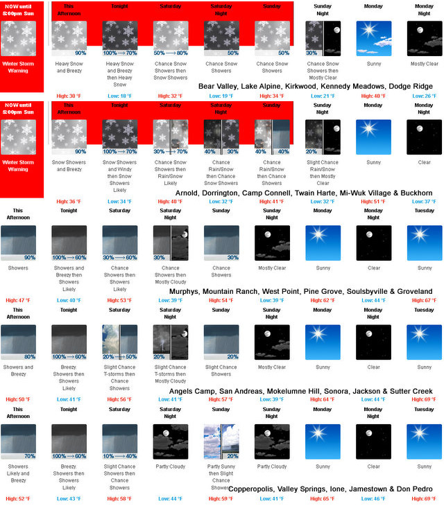

Winter Storm Warning
URGENT – WINTER WEATHER MESSAGE
National Weather Service Sacramento CA
158 AM PDT Fri Mar 29 2024
CAZ068-069-292200-
/O.CON.KSTO.WS.W.0015.240329T1500Z-240401T0000Z/
Western Plumas County/Lassen Park-
West Slope Northern Sierra Nevada-
Including the cities of Chester, Quincy, and Blue Canyon
158 AM PDT Fri Mar 29 2024
…WINTER STORM WARNING REMAINS IN EFFECT FROM 8 AM THIS MORNING
TO 5 PM PDT SUNDAY…
* WHAT…Heavy snow expected. Total snow accumulations of 8 to 20
inches, up to 30 inches at the highest peaks. Winds gusting as
high as 40 mph.
* WHERE…Western Plumas County/Lassen Park and West Slope
Northern Sierra Nevada above 4000 feet, including Interstate
80 over Donner Summit and Highway 50 over Echo Summit.
* WHEN…From 8 AM this morning to 5 PM PDT Sunday.
* IMPACTS…Travel could be very difficult from delays, snow-
covered roads, and chain controls. The hazardous conditions
will impact holiday weekend travelers.
* ADDITIONAL DETAILS…Snow levels 3500 to 4500 feet. Heaviest
snow expected this afternoon and into Saturday morning with
snowfall rates up to an inch per hour at times.
PRECAUTIONARY/PREPAREDNESS ACTIONS…
If you must travel, keep an extra flashlight, food, and water in
your vehicle in case of an emergency.
The latest road conditions for the state you are calling from can
be obtained by calling 5 1 1.
$$
Winter Storm Warning Remains in Effect for High Country to 5pm Easter Sunday. added by admin on
View all posts by admin →