

Arnold, CA…Heat Advisory in Effect Until Tomorrow Night for Lower Elevations. Full detailed forecasts from the NWS for the West Slope & Mother Lode are below…

Detailed forecast for
West Slope Northern Sierra Nevada
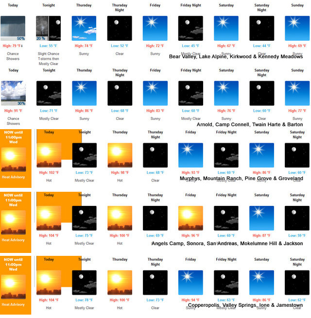
Today
Sunny in the morning, then mostly cloudy with a chance of rain showers and a slight chance of thunderstorms in the afternoon. Highs 76 to 91 higher elevations…91 to 101 lower elevations. Light winds becoming west up to 10 mph in the afternoon.
Tonight
Mostly clear. At higher elevations, a slight chance of showers and thunderstorms in the evening. Cooler. Lows 53 to 68 higher elevations…64 to 78 lower elevations. Prevailing west winds up to 10 mph in the evening becoming light.
Thursday
Sunny. Highs 71 to 86 higher elevations…86 to 96 lower elevations. Light winds becoming southwest 5 to 15 mph in the afternoon. Gusts up to 30 mph.
Thursday Night
Clear, cooler. Lows 50 to 65 higher elevations…60 to 74 lower elevations. Prevailing southwest winds up to 10 mph shifting to the southeast after midnight. Gusts up to 25 mph.
Friday
Sunny. Highs 68 to 83 higher elevations…82 to 92 lower elevations. Prevailing southeast winds up to 10 mph shifting to the southwest with gusts to around 30 mph in the afternoon.
Friday Night
Clear, cooler. Lows 47 to 62.
Saturday
Sunny. Highs 66 to 81.
Saturday Night Through Tuesday
Clear. Lows 47 to 62. Highs 69 to 84.
Detailed forecast for
Motherlode
Today
Sunny. Highs 96 to 108. Light winds becoming west up to 10 mph in the afternoon.
Tonight
Clear. Lows 69 to 79. Prevailing west winds up to 10 mph in the evening becoming light.
Thursday
Sunny. Highs 91 to 103. Light winds becoming southwest up to 10 mph in the afternoon.
Thursday Night
Clear, cooler. Lows 64 to 74. Prevailing southwest winds up to 10 mph in the evening becoming light.
Friday
Sunny. Highs 87 to 97. Light winds becoming southwest up to 10 mph in the afternoon.
Friday Night
Clear, cooler. Lows 55 to 65.
Saturday
Sunny. Highs 79 to 89.
Saturday Night Through Tuesday
Clear. Lows 55 to 68. Highs 80 to 95.
Heat Advisory
URGENT – WEATHER MESSAGE
National Weather Service Sacramento CA
200 AM PDT Wed Jul 24 2024
CAZ015>019-066-067-250000-
/O.CON.KSTO.HT.Y.0004.000000T0000Z-240725T0600Z/
Northern Sacramento Valley-Central Sacramento Valley-
Southern Sacramento Valley-Carquinez Strait and Delta-
Northern San Joaquin Valley-Northeast Foothills/Sacramento Valley-
Motherlode-
Including the cities of Redding, Red Bluff, Chico, Oroville,
Marysville/Yuba City, Sacramento, Fairfield/Suisun, Stockton,
Modesto, Paradise, Grass Valley, and Jackson
200 AM PDT Wed Jul 24 2024
…HEAT ADVISORY REMAINS IN EFFECT UNTIL 11 PM PDT THIS EVENING…
* WHAT…Hot conditions again today, although slightly cooler with
high temperatures 100 to 110, hottest in the Northern Sacramento
Valley.
* WHERE…Sacramento Valley, Northeast Foothills of the Sacramento
Valley, Motherlode, Carquinez Strait and Delta, and Northern San
Joaquin Valley.
* WHEN…Until 11 PM PDT this evening.
* IMPACTS…Heat related illnesses will be possible, especially
for groups that are sensitive to heat.
* ADDITIONAL DETAILS…Areas of major HeatRisk are expected.
This level of heat could impact outdoor activities.
PRECAUTIONARY/PREPAREDNESS ACTIONS…
Drink plenty of fluids, stay in an air-conditioned room, stay out
of the sun, and check up on relatives and neighbors.
&&
Heat Advisory in Effect Until Tomorrow Night for Lower Elevations added by admin on
View all posts by admin →