

Arnold, CA…The National Weather Service in Sacramento is forecasting another system to pass through our area today. Snow level at 5,000 ft & rising for this wave. Full details for the West Slope & Motherlode are below…
ThePineTree.net Weather Sponsored By Fox Security

Detailed forecast for
West Slope Northern Sierra Nevada
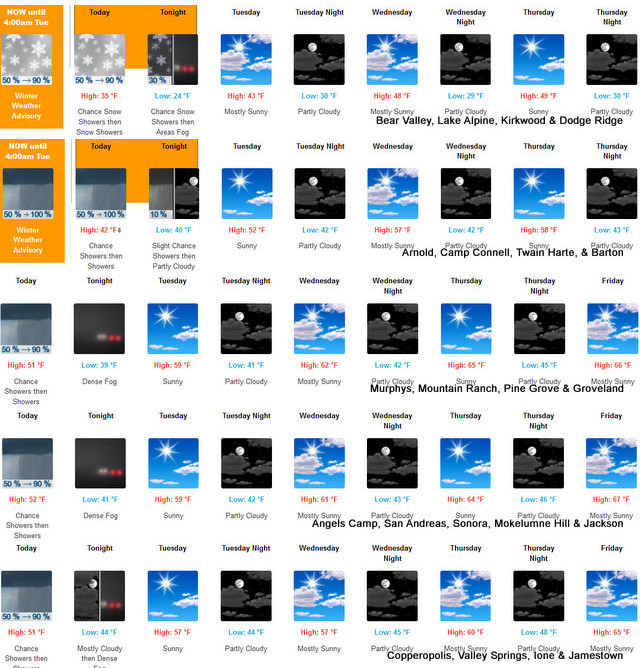
Today
At lower elevations, a chance of rain and snow showers late in the morning. Rain showers in the afternoon. At higher elevations, a chance of snow showers late in the morning. Snow showers and rain showers in the afternoon. Areas of fog late in the afternoon. Highs 30 to 45 higher elevations…38 to 52 lower elevations. No snow accumulation lower elevations…up to 3 inches higher elevations. Snow level 5000 feet increasing to 6500 feet in the afternoon. Prevailing south winds up to 10 mph with gusts to around 30 mph. Over ridges, prevailing southwest winds 15 to 25 mph becoming southwest 15 to 25 mph in the afternoon.
Tonight
Mostly cloudy. At lower elevations, a chance of rain showers in the evening. At higher elevations, a chance of rain and snow showers in the evening. Areas of fog in the evening. Patchy fog after midnight. Lows 21 to 36 higher elevations… 32 to 42 lower elevations. No snow accumulation lower elevations…up to 1 inch higher elevations. Snow level 7000 feet. Prevailing south winds up to 10 mph with gusts to around 35 mph. Over ridges, prevailing southwest winds 15 to 25 mph decreasing to 5 to 15 mph after midnight.
Tuesday
Partly cloudy in the morning then clearing. Areas of fog…locally dense in the morning. Not as cool. Highs 38 to 53 higher elevations…49 to 61 lower elevations. Prevailing northeast winds up to 10 mph.
Tuesday Night
Mostly clear. Lows 26 to 41 higher elevations… 35 to 47 lower elevations. Prevailing northeast winds up to 10 mph.
Wednesday
Mostly sunny in the morning then becoming partly cloudy. Not as cool. Highs 43 to 58 higher elevations…55 to 65 lower elevations. Prevailing northeast winds up to 10 mph.
Wednesday Night
Partly cloudy. Lows 29 to 44.
Thursday
Mostly sunny. Highs 48 to 63.
Thursday Night
Mostly clear. Lows 30 to 45.
Friday
Partly cloudy. Highs 45 to 60.
Friday Night
Mostly cloudy. Lows 30 to 45.
Saturday Through Sunday
Mostly cloudy with a chance of rain and snow showers. Highs 38 to 53. Lows 29 to 44.
Detailed forecast for
Motherlode
Today
A slight chance of rain showers early in the morning. A chance of rain showers late in the morning, then rain showers in the afternoon. Highs 44 to 54. Prevailing southeast winds up to 10 mph.
Tonight
Mostly cloudy. A chance of rain showers in the evening. Patchy fog after midnight. Lows 37 to 45. Light winds.
Tuesday
Widespread fog…locally dense in the morning. Mostly sunny. Not as cool. Highs 55 to 61. Light winds.
Tuesday Night
Mostly clear. Lows 38 to 46. Light winds.
Wednesday
Mostly sunny in the morning then becoming partly cloudy. Highs 56 to 64. Light winds.
Wednesday Night
Partly cloudy. Lows 38 to 48.
Thursday
Mostly sunny. Highs 59 to 67.
Thursday Night
Mostly clear. Lows 41 to 49.
Friday
Partly cloudy. Highs 60 to 68.
Friday Night
Mostly cloudy. Lows 43 to 51.
Saturday Through Sunday
Mostly cloudy with a chance of rain showers. Highs 51 to 62. Lows 42 to 51.
Winter Weather Advisory
URGENT – WINTER WEATHER MESSAGE
National Weather Service Sacramento CA
331 AM PST Mon Dec 16 2024
CAZ068-069-162315-
/O.CON.KSTO.WW.Y.0020.241216T1200Z-241217T1200Z/
Western Plumas County/Lassen Park-West Slope Northern Sierra
Nevada-
Including the cities of Blue Canyon, Quincy, and Chester
331 AM PST Mon Dec 16 2024
…WINTER WEATHER ADVISORY REMAINS IN EFFECT UNTIL 4 AM PST TUESDAY
ABOVE 5000 FEET…
* WHAT…Snow expected. Total snow accumulations of 2 to 6 inches
above 5000 feet, locally higher over peaks. Winds gusting as high
as 40 mph.
* WHERE…West Slope Northern Sierra Nevada and Western Plumas
County/Lassen Park Counties.
* WHEN…Until 4 AM PST Tuesday.
* IMPACTS…Plan on slippery road conditions. The hazardous
conditions could impact the Monday morning and evening commutes.
* ADDITIONAL DETAILS…Snow levels around 4500 feet this morning,
rising to near 6000 feet in the afternoon.
PRECAUTIONARY/PREPAREDNESS ACTIONS…
Check the latest road conditions from Caltrans online at
quickmap.dot.ca.gov or dial 5 1 1.
&&
$$
For more information, visit us at www.weather.gov/sto/
Wood
White Stuff in the High Country & A Bit of Rain Down the Hill added by admin on
View all posts by admin →