

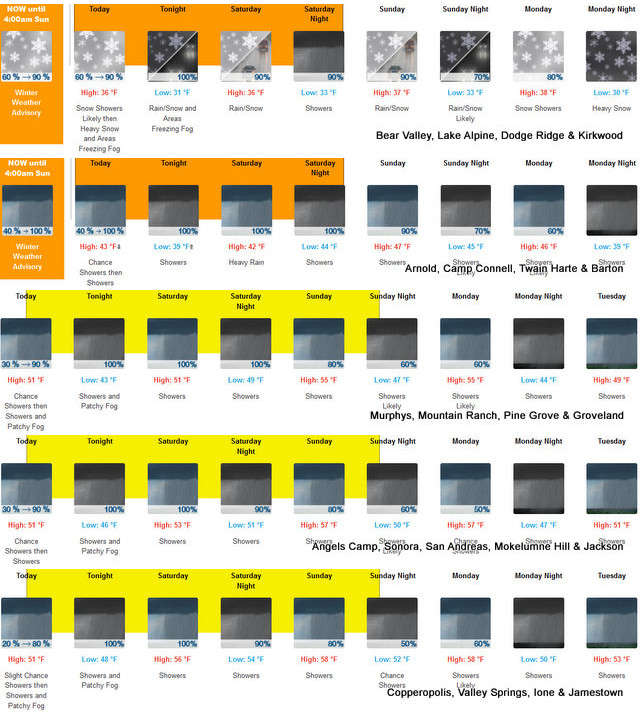
Arnold, CA…Snow expected above 6500 feet. Total snow accumulations of 12 to 18 inches above 7000 feet, up to 2 feet over the highest peaks. Winds gusting as high as 45 mph, up to 60 mph for the highest peaks. At lower elevations…Excessive runoff will result in sharp rises on rivers, creeks, and streams. Creeks and streams may rise out of their banks. Flooding may occur in poor drainage and urban areas. There is the potential for mud and rock slides in the foothills.
ThePineTree.net Weather Sponsored By Fox Security

Winter Weather Advisory
URGENT – WINTER WEATHER MESSAGE
National Weather Service Sacramento CA
146 AM PST Fri Jan 31 2025
CAZ068-069-010015-
/O.CON.KSTO.WW.Y.0002.250131T1200Z-250202T1200Z/
Western Plumas County/Lassen Park-West Slope Northern Sierra
Nevada-
Including the cities of Blue Canyon, Chester, and Quincy
146 AM PST Fri Jan 31 2025
…WINTER WEATHER ADVISORY REMAINS IN EFFECT UNTIL 4 AM PST SUNDAY
ABOVE 6500 FEET…
* WHAT…Snow expected above 6500 feet. Total snow accumulations of
12 to 18 inches above 7000 feet, up to 2 feet over the highest
peaks. Winds gusting as high as 45 mph, up to 60 mph for the
highest peaks.
* WHERE…West Slope Northern Sierra Nevada and Western Plumas
County/Lassen Park Counties.
* WHEN…Until 4 AM PST Sunday.
* IMPACTS…Plan on slippery travel conditions with mountain travel
delays and chain controls. Gusty winds could bring down tree
branches. Weather conditions could impact the evening commute.
* ADDITIONAL DETAILS…Heaviest snow expected overnight Friday into
early Saturday. Colder storm with lower snow levels and heavier
snow amounts expected next week.
PRECAUTIONARY/PREPAREDNESS ACTIONS…
Check the latest road conditions from Caltrans online at
quickmap.dot.ca.gov or dial 5 1 1.
&&
$$
For more information, visit us at www.weather.gov/sto/
EK
Flood Watch
Flood Watch
National Weather Service Sacramento CA
138 AM PST Fri Jan 31 2025
CAZ013-015>019-063-066-067-010015-
/O.CON.KSTO.FA.A.0001.250131T2000Z-250203T0600Z/
/00000.0.ER.000000T0000Z.000000T0000Z.000000T0000Z.OO/
Shasta Lake Area / Northern Shasta County-Northern Sacramento
Valley-Central Sacramento Valley-Southern Sacramento Valley-
Carquinez Strait and Delta-Northern San Joaquin Valley-Mountains
Southwestern Shasta County to Western Colusa County-Northeast
Foothills/Sacramento Valley-Motherlode-
Including the cities of Stockton, Chico, Marysville/Yuba City,
Shasta Dam, Alder Springs, Jackson, Fairfield/Suisun, Redding,
Red Bluff, Paradise, Oroville, Sacramento, Grass Valley, and
Modesto
138 AM PST Fri Jan 31 2025
…FLOOD WATCH REMAINS IN EFFECT FROM NOON PST TODAY THROUGH SUNDAY
EVENING BELOW 3000 FEET…
* WHAT…The potential for flooding caused by excessive rainfall
continues.
* WHERE…A portion of northern California, including the following
areas, Carquinez Strait and Delta, Sacramento Valley, Motherlode,
Mountains Southwestern Shasta County to Western Colusa County,
Northeast Foothills, Northern San Joaquin Valley, and Shasta Lake
Area / Northern Shasta County.
* WHEN…From noon PST today through Sunday evening.
* IMPACTS…Excessive runoff will result in sharp rises on rivers,
creeks, and streams. Creeks and streams may rise out of their
banks. Flooding may occur in poor drainage and urban areas. There
is the potential for mud and rock slides in the foothills.
* ADDITIONAL DETAILS…
– Periods of moderate to heavy rainfall are expected with
totals from 2 to 4 inches over 48 hours. Heaviest rain
expected from this afternoon through Saturday afternoon.
– http://www.weather.gov/safety/flood
PRECAUTIONARY/PREPAREDNESS ACTIONS…
You should monitor later forecasts and be alert for possible Flood
Warnings. Those living in areas prone to flooding should be prepared
to take action should flooding develop.
&&
$$
EK
Winter Returns…Up to 2 Feet of Snow at Highest Elevations & Flood Watches Down the Hill added by admin on
View all posts by admin →