


Arnold, CA…This highway information is the latest reported by caltrans as of Thursday, March 6th, 2025 at 07:15 AM. Details for each Hwy are below…
SR 4
[IN THE CENTRAL CALIFORNIA AREA]
Is closed from the Mt Reba Turnoff to the Jct of SR 89 /Ebbetts Pass/ (Alpine Co) – For the Winter – Motorists are advised to use an alternate route
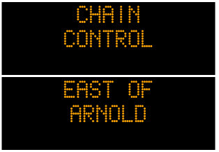
Chains are required on all vehicles except 4-wheel-drive vehicles with snow tires on all 4 wheels from 1 mi east of Arnold (Calaveras Co) to the Mt Reba Turnoff (Alpine Co)
Please research chain control locations as Caltrans is currently working to update chain control descriptions for consistency with internet mapping, like Google Maps & Mapquest
1-way controlled traffic at various locations from Van Allen Dr to Escalon Bellota Rd /in Farmington/ (San Joaquin Co) from 0900 hrs to 1500 hrs Monday thru Friday thru 3/7/25 – Due to construction
SR 88
[IN THE CENTRAL CALIFORNIA AREA & SIERRA NEVADA]
Chains are required on all vehicles except 4-wheel-drive vehicles with snow tires on all 4 wheels from 3.6 mi west of Dew Drop (Amador Co) to 5 mi west of Picketts Jct (Alpine Co)
Please research chain control locations as Caltrans is currently working to update chain control descriptions for consistency with internet mapping, like Google Maps & Mapquest
SR 108
[IN THE CENTRAL CALIFORNIA AREA & SIERRA NEVADA]
Is closed from 7.2 mi east of Strawberry to 5.3 mi west of the Jct of US 395 /Sonora Pass/ (Tuolumne,Mono Co) – For the winter – Motorists are advised to use an alternate route
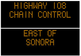
Chains are required on all vehicles except 4-wheel-drive vehicles with snow tires on all 4 wheels from Camp Sunshine to 7.2 mi east of Strawberry (Tuolumne Co)
Please research chain control locations as caltrans is currently working to update chain control descriptions for consistency with internet mapping, like google maps & mapquest.
[YOSEMITE NAT’L PARK]
For Yosemite Nat’l Park road information call 209-372-0200
SR 120
[IN THE CENTRAL CALIFORNIA AREA & SIERRA NEVADA]
Is closed from Crane Flat to 3.5 mi west of the North Jct of US 395 /Tioga Pass/ (Tuolumne, Mono Co) – For the winter – Motorists are advised to use an alternate route
Is closed from 5.1 mi east of the South Jct of US 395 to 7.5 mi west of the Jct of US 6 (Mono Co) – For the winter – Motorists are advised to use an alternate route
Chains are required on all vehicles except 4-wheel-drive vehicles with snow tires on all 4 wheels from 2.5 mi west of Groveland to Yosemite National Park Boundary (Tuolumne Co)
Please research chain control locations as Caltrans is currently working to update chain control descriptions for consistency with internet mapping, like Google Maps & Mapquest
[YOSEMITE NAT’L PARK]
For Yosenite Nat’l Park road information call 209-372-0200
Chain Controls on Hwys 4, 88, 108 & 120 this Morning added by admin on
View all posts by admin →