


Arnold, CA…After a bit of a break Mother Nature is bringing weather back with a vengeance for Christmas. Snow levels will start high & then drop as the week goes on. Flood watches for lower elevations & more. Full forecasts from NWS Sacramento for the West Slope & Mother Lode are below. Here we go…
ThePineTree.net Weather Sponsored By Fox Security

Detailed forecast for
West Slope Northern Sierra Nevada
Today
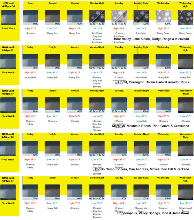
Heavy rain showers. Highs 37 to 52 higher elevations… 47 to 57 lower elevations. Prevailing south winds 10 to 20 mph with gusts to around 55 mph…except south 10 to 35 mph with gusts to around 60 mph over ridges.
Tonight
Heavy rain showers and a slight chance of thunderstorms at lower elevations…and heavy rain showers, heavy snow showers and a slight chance of thunderstorms at higher elevations. Breezy, colder. Some thunderstorms may produce heavy rainfall. Lows 29 to 44 higher elevations…42 to 50 lower elevations. No snow accumulation lower elevations…4 to 9 inches higher elevations. Snow level above 8000 feet. Prevailing south winds 10 to 25 mph decreasing to 5 to 15 mph after midnight. Gusts up to 50 mph. Over ridges…prevailing southwest winds 20 to 35 mph.
Monday
Rain showers at lower elevations…and rain showers and heavy snow showers at higher elevations. Highs 34 to 49 higher elevations…45 to 55 lower elevations. No snow accumulation lower elevations…1 to 7 inches higher elevations. Snow level above 8000 feet. Prevailing south winds up to 15 mph with gusts to around 35 mph.
Monday Night
Rain showers and a chance of snow showers in the evening, then a chance of rain and snow showers after midnight. Lows 29 to 44 higher elevations…40 to 50 lower elevations. No snow accumulation lower elevations…up to 1 inch higher elevations. Snow level 7500 feet. Prevailing south winds up to 10 mph with gusts to around 30 mph…except south up to 25 mph over ridges.
Tuesday
Mostly cloudy. A chance of rain and snow showers. Highs 37 to 52 higher elevations…47 to 59 lower elevations. Snow level 7000 feet. Prevailing south winds up to 15 mph with gusts to around 35 mph…except south up to 25 mph over ridges.
Tuesday Night
Heavy rain showers and heavy snow showers. Colder. Moderate snow accumulations possible. Lows 28 to 43.
Wednesday
Rain showers and heavy snow showers. Heavy snow accumulations possible. Highs 33 to 48.
Wednesday Night Through Friday
Heavy rain showers and heavy snow showers. Heavy snow accumulations possible. Lows 27 to 42. Highs 31 to 46.
Friday Night
Heavy rain and snow showers likely. Moderate snow accumulations possible. Lows 24 to 39.
Saturday
Mostly cloudy with a chance of rain and snow showers. Not as cool. Highs 34 to 49.
Detailed forecast for
Motherlode
Today
Rain showers. Highs 52 to 58. Prevailing south winds 5 to 15 mph with gusts to around 35 mph.
Tonight
Heavy rain showers and a slight chance of thunderstorms. Some thunderstorms may produce heavy rainfall. Lows 45 to 53. Prevailing south winds up to 15 mph with gusts to around 35 mph.
Monday
Rain showers. Highs 50 to 56. Prevailing southeast winds up to 10 mph.
Monday Night
Rain showers and a slight chance of thunderstorms in the evening, then a chance of rain showers and a slight chance of thunderstorms after midnight. Some thunderstorms may produce heavy rainfall. Lows 44 to 50. Light winds.
Tuesday
Cloudy with a chance of rain showers. Highs 52 to 58. Prevailing southeast winds up to 10 mph. Gusts up to 25 mph in the afternoon.
Tuesday Night
Rain showers. Lows 41 to 49.
Wednesday
Rain showers and a slight chance of thunderstorms. Some thunderstorms may produce heavy rainfall. Highs 47 to 53.
Wednesday Night Through Friday
Rain showers. Lows 39 to 49. Highs 44 to 51.
Friday Night And Saturday
Mostly cloudy with a chance of rain showers. Lows 36 to 44. Highs 47 to 53.
Flood Watch
Flood Watch
National Weather Service Sacramento CA
103 PM PST Sat Dec 20 2025
.A series of warm atmospheric rivers will bring moderate to heavy
rain to the Valley, foothills, and mountains the week of Christmas.
The prolonged period of rain will bring the risk of flooding to the
Sacramento Valley, northern San Joaquin Valley, northern Sierra
Nevada and adjacent foothills, as well as the Coastal Range.
CAZ013>019-063-066>069-220000-
/O.CON.KSTO.FA.A.0004.251221T0000Z-251227T0000Z/
/00000.0.ER.000000T0000Z.000000T0000Z.000000T0000Z.OO/
Shasta Lake Area / Northern Shasta County-Burney Basin / Eastern
Shasta County-Northern Sacramento Valley-Central Sacramento
Valley-Southern Sacramento Valley-Carquinez Strait and Delta-
Northern San Joaquin Valley-Mountains Southwestern Shasta County
to Western Colusa County-Northeast Foothills/Sacramento Valley-
Motherlode-Western Plumas County/Lassen Park-West Slope Northern
Sierra Nevada-
Including the cities of Marysville/Yuba City, Burney, Paradise,
Chico, Sacramento, Alder Springs, Modesto, Blue Canyon, Jackson,
Stockton, Fairfield/Suisun, Grass Valley, Red Bluff, Shasta Dam,
Redding, Quincy, Oroville, and Chester
103 PM PST Sat Dec 20 2025
…FLOOD WATCH REMAINS IN EFFECT THROUGH FRIDAY AFTERNOON…
* WHAT…Flooding caused by excessive rainfall continues to be
possible.
* WHERE…A portion of northern California, including the following
areas, the Sacramento Valley, northern San Joaquin Valley, Delta
region, Sierra Nevada and adjacent foothills, and Coastal Range.
* WHEN…Through Friday afternoon.
* IMPACTS…Excessive runoff will result in rises along area rivers,
creeks, streams. Small streams and creeks may rise out of their
banks. Flooding may occur in low-lying, poor drainage, and urban
areas. Mudslides and rockslides may occur in mountain and foothill
areas.
* ADDITIONAL DETAILS…
– Periods of moderate to heavy rain are forecast the week of
Christmas. Debris flows are not expected over recent burn
scars, but do anticipate enhanced runoff in/below scars.
– http://www.weather.gov/safety/flood
PRECAUTIONARY/PREPAREDNESS ACTIONS…
You should monitor later forecasts and be alert for possible Flood
Warnings. Those living in areas prone to flooding should be prepared
to take action should flooding develop.
&&
$$
JS
Winter Storm Watch
URGENT – WINTER WEATHER MESSAGE
National Weather Service Sacramento CA
413 PM PST Sat Dec 20 2025
CAZ068-069-220000-
/O.CON.KSTO.WS.A.0009.251224T0600Z-251226T1800Z/
Western Plumas County/Lassen Park-West Slope Northern Sierra
Nevada-
Including the cities of Quincy, Blue Canyon, and Chester
413 PM PST Sat Dec 20 2025
…WINTER STORM WATCH REMAINS IN EFFECT FROM TUESDAY EVENING THROUGH
FRIDAY MORNING…
* WHAT…Heavy snow possible. Accumulation amounts uncertain at this
time but may range from around a foot at 5500 feet and up 4 feet
at highest elevations. Winds could gust as high as 45 mph.
* WHERE…West Slope Northern Sierra Nevada and Western Plumas
County/Lassen Park including Interstate 80 and Highway 50.
* WHEN…From Tuesday evening through Friday morning.
* IMPACTS…Dangerous travel conditions with chain controls and road
closures possible. Low visibility due to combination of wind and
heavy snow.
* ADDITIONAL DETAILS…Snow accumulations will remain near or above
pass level through Tuesday, then drop to around 5500 feet during
the day Wednesday.
PRECAUTIONARY/PREPAREDNESS ACTIONS…
Check the latest road conditions from Caltrans online at
quickmap.dot.ca.gov or dial 5 1 1.
&&
$$
For more information, visit us at www.weather.gov/sto/
A White Christmas on the Way With Up to 4 Feet of Snow at Higher Elevations added by admin on
View all posts by admin →
Speaking of White.
2025 has been a GREAT year for White Collar Crimes.
Thanks to Donald J Trump 2025 has been a record year for white collar manipulations of the law.
And the fact that the POTUS will not only condone your activities, but pardon you for any crimes you have been found guilty of, this is a great time to be a crypto currency criminal, a stock market criminal, a political criminal, a drug syndicate dealer, whatever.
As long as you give Trump a piece of your “pie” you are free to carry on taking advantage of this administrations lax enforcing of laws.
Thank you Donald Trump.
But if you are a typical dumb Trump backer, don’t plan on things being lax for you. See, his base is the foundation these misdeeds are built on. Their stupidity is what allows lawbreakers to succeed. That and an immoral leader.
Happy Days Are Here Again! You Go Donald
I’m into Black Meat myself! Adam Fairy on live oak ct..