

Arnold, CA…Today, Heavy rain and snow. Highs 27 to 42 higher elevations… 37 to 47 lower elevations. Little or no snow accumulation lower elevations…10 to 16 inches higher elevations. Snow level 5500 feet. Prevailing south winds up to 15 mph. Gusts up to 25 mph increasing to 40 mph in the afternoon. Over ridges… Prevailing south winds 5 to 15 mph increasing to 15 to 30 mph in the afternoon. Tonight, Heavy rain and snow in the evening, then heavy snow showers and a slight chance of thunderstorms after midnight. Colder. Lows 12 to 27 higher elevations…25 to 35 lower elevations. Snow accumulation 3 to 6 inches lower elevations… Except 13 to 18 inches higher elevations. Snow level 4500 feet in the evening. Prevailing southwest winds 10 to 20 mph with gusts to around 50 mph…except southwest 10 to 45 mph over ridges.
ThePineTree.net Weather Sponsored By Fox Security

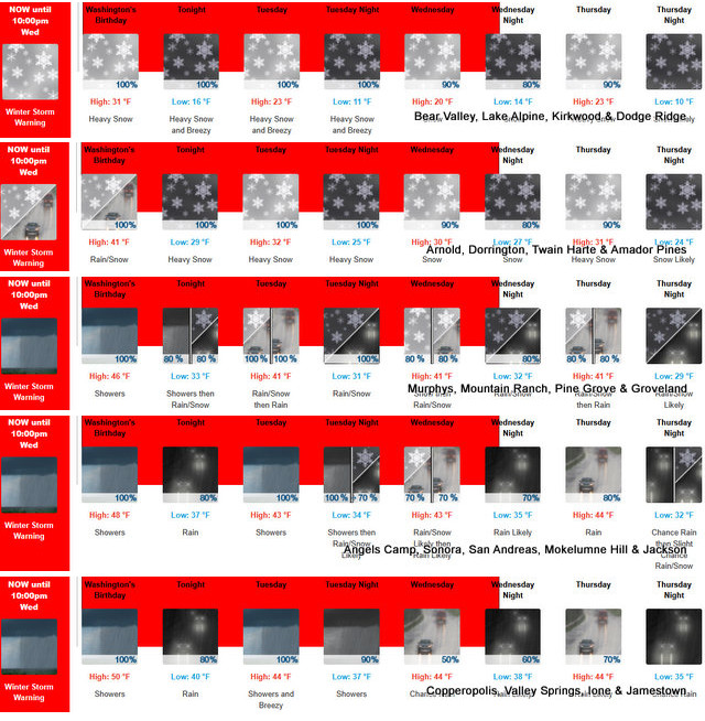
URGENT - WINTER WEATHER MESSAGE
National Weather Service Sacramento CA
1129 AM PST Sun Feb 15 2026

CAZ013-014-063-066>069-170030-
/O.CON.KSTO.WS.W.0002.260216T0600Z-260219T0600Z/
Shasta Lake Area / Northern Shasta County-Burney Basin / Eastern
Shasta County-Mountains Southwestern Shasta County to Western
Colusa County-Northeast Foothills/Sacramento Valley-Motherlode-
Western Plumas County/Lassen Park-West Slope Northern Sierra
Nevada-
Including the cities of Burney, Quincy, Chester, Shasta Dam,
Alder Springs, Grass Valley, Jackson, Paradise, and Blue Canyon
1129 AM PST Sun Feb 15 2026

...WINTER STORM WARNING REMAINS IN EFFECT FROM 10 PM THIS EVENING TO
10 PM PST WEDNESDAY...

* WHAT...Heavy snow expected. Accumulation amounts range from up to
  1 foot 1500 to 2500 feet, 1 to 2 feet at 2500 to 3500 feet and 4
  to 8 feet at higher elevations. Wind gusts of 45 to 55mph expected.

* WHERE...West Slope Northern Sierra Nevada and Western Plumas
  County/Lassen Park including Interstate 80 and Highway 50,
  northern Shasta County including portions of Interstate 5, the
  Coastal Range, and foothill regions of the Sierra Nevada.

* WHEN...From 10 PM this evening to 10 PM PST Wednesday.

* IMPACTS...Dangerous to near impossible travel conditions with
  chain controls and road closures. Low visibility due to a
  combination of wind and heavy snow.

* ADDITIONAL DETAILS...Snow levels will be around 4500-5500 feet
  tonight through Monday. 2500 to 3500 feet snow levels by Monday
  night and 1500 to 2500 feet Tuesday into Wednesday. Potential to
  see snow levels as low as 750 feet for areas along the Coastal
  Range, across Shasta County including Shasta Lake, and in the
  southern Cascades.

PRECAUTIONARY/PREPAREDNESS ACTIONS...

Check the latest road conditions from Caltrans online at
quickmap.dot.ca.gov or dial 5 1 1.

&&

$$

For more information, visit us at www.weather.gov/sto/
Winter Storm Warning
URGENT - WINTER WEATHER MESSAGE
National Weather Service Sacramento CA
1129 AM PST Sun Feb 15 2026

CAZ013-014-063-066>069-170030-
/O.CON.KSTO.WS.W.0002.260216T0600Z-260219T0600Z/
Shasta Lake Area / Northern Shasta County-Burney Basin / Eastern
Shasta County-Mountains Southwestern Shasta County to Western
Colusa County-Northeast Foothills/Sacramento Valley-Motherlode-
Western Plumas County/Lassen Park-West Slope Northern Sierra
Nevada-
Including the cities of Burney, Quincy, Chester, Shasta Dam,
Alder Springs, Grass Valley, Jackson, Paradise, and Blue Canyon
1129 AM PST Sun Feb 15 2026

...WINTER STORM WARNING REMAINS IN EFFECT FROM 10 PM THIS EVENING TO
10 PM PST WEDNESDAY...

* WHAT...Heavy snow expected. Accumulation amounts range from up to
  1 foot 1500 to 2500 feet, 1 to 2 feet at 2500 to 3500 feet and 4
  to 8 feet at higher elevations. Wind gusts of 45 to 55mph expected.

* WHERE...West Slope Northern Sierra Nevada and Western Plumas
  County/Lassen Park including Interstate 80 and Highway 50,
  northern Shasta County including portions of Interstate 5, the
  Coastal Range, and foothill regions of the Sierra Nevada.

* WHEN...From 10 PM this evening to 10 PM PST Wednesday.

* IMPACTS...Dangerous to near impossible travel conditions with
  chain controls and road closures. Low visibility due to a
  combination of wind and heavy snow.

* ADDITIONAL DETAILS...Snow levels will be around 4500-5500 feet
  tonight through Monday. 2500 to 3500 feet snow levels by Monday
  night and 1500 to 2500 feet Tuesday into Wednesday. Potential to
  see snow levels as low as 750 feet for areas along the Coastal
  Range, across Shasta County including Shasta Lake, and in the
  southern Cascades.

PRECAUTIONARY/PREPAREDNESS ACTIONS...

Check the latest road conditions from Caltrans online at
quickmap.dot.ca.gov or dial 5 1 1.

&&

$$

For more information, visit us at www.weather.gov/sto/

DA
Buckle Up, Here We Go! Over 8 Feet of Snow Possible at Higher Elevations ~ Weather Sponsored by Fox Security added by admin on
View all posts by admin →
Why are you telling Adam that?