


Bear Valley, CA…West Slope Northern Sierra Nevada. Today At lower elevations, rain likely in the morning, then heavy rain in the afternoon. At higher elevations, rain and snow likely in the morning, then heavy rain and heavy snow in the afternoon. Windy. Highs 36 to 50 higher elevations…46 to 54 lower elevations. No snow accumulation lower elevations…2 to 4 inches higher elevations. Snow level above 8000 feet. Prevailing south winds 15 to 30 mph with gusts to around 50 mph… Except southwest 25 to 45 mph with gusts to around 60 mph over ridges.
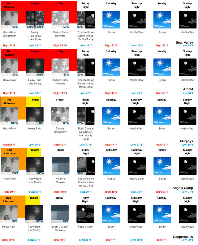
Tonight Heavy rain at lower elevations…and heavy rain and heavy snow at higher elevations. Breezy, colder. Lows 21 to 36 higher elevations…33 to 39 lower elevations. No snow accumulation lower elevations…6 to 11 inches higher elevations. Snow level above 8000 feet decreasing to 6500 feet after midnight. Prevailing south winds 15 to 25 mph with gusts to around 50 mph…except southwest 25 to 45 mph over ridges.
Friday Mostly cloudy. A chance of rain and snow showers in the morning, then a chance of snow showers in the afternoon. Highs 21 to 36 higher elevations…35 to 41 lower elevations. Snow level 4500 feet in the morning. Prevailing southwest winds 5 to 15 mph with gusts to around 30 mph…except southwest 15 to 30 mph over ridges.
Friday Night Partly cloudy. A chance of snow showers in the evening. Much colder. Lows 6 to 21 higher elevations…21 to 27 lower elevations. Prevailing southwest winds up to 10 mph shifting to the northeast after midnight.
Saturday Mostly sunny. Not as cold. Highs 25 to 40 higher elevations…38 to 46 lower elevations. Prevailing northeast winds up to 10 mph.
Saturday Night Mostly clear. Lows 15 to 30.
Sunday Mostly sunny. Highs 30 to 45.
Sunday Night Through Tuesday NightMostly clear. Lows 18 to 33. Highs 35 to 50.
Wednesday Partly cloudy. Highs 36 to 51.
Heavy Rain & Up To 15 Inches Of Snow At Higher Elevations added by admin on
View all posts by admin →