


Bear Valley, CA…The National Weather Service is projecting a busy weather week along the West Slope Northern Sierra Nevada Tonight Snow showers. Lows 13 to 28 higher elevations…26 to 34 lower elevations. Snow accumulation of 3 to 6 inches. Prevailing south winds 5 to 15 mph with gusts to around 35 mph… Except south 20 to 35 mph over ridges.
Tuesday Snow showers. Not as cold. Highs 23 to 37 higher elevations…34 to 42 lower elevations. Snow accumulation of 1 to 6 inches lower elevations…except 3 to 5 inches higher elevations. Prevailing southeast winds 5 to 15 mph with gusts to around 30 mph…except south 15 to 30 mph over ridges.
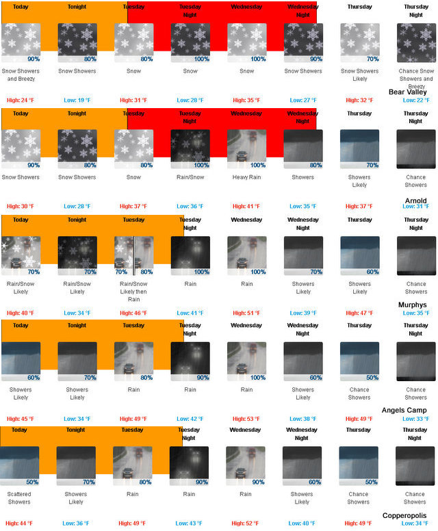
Tuesday Night At lower elevations, snow showers and heavy rain showers in the evening, then heavy rain showers after midnight. At higher elevations, snow showers in the evening, then snow showers and heavy rain showers after midnight. Lows 23 to 35 higher elevations…32 to 40 lower elevations. Snow accumulation 3 to 6 inches lower elevations…except 6 to 12 inches higher elevations. Snow level 4000 feet increasing to 5000 feet after midnight. Prevailing south winds 5 to 15 mph with gusts to around 35 mph…except southwest 15 to 30 mph over ridges.
Wednesday Heavy rain and snow showers. Not as cool. Highs 30 to 42 higher elevations…39 to 47 lower elevations. No snow accumulation lower elevations…3 to 8 inches higher elevations. Snow level 6000 feet. Prevailing south winds 10 to 20 mph with gusts to around 40 mph…except southwest 25 to 35 mph over ridges.
Wednesday Night Rain and snow showers. Lows 21 to 35 higher elevations…31 to 41 lower elevations. No snow accumulation lower elevations…1 to 7 inches higher elevations. Snow level 6000 feet. Prevailing southwest winds 10 to 20 mph with gusts to around 45 mph…except southwest 25 to 40 mph over ridges.
Thursday Rain and snow showers likely. Moderate snow accumulations possible. Highs 30 to 45.
Thursday Night Mostly cloudy with a chance of rain and snow showers. Breezy, colder. Lows 18 to 33.
Friday Mostly cloudy with a slight chance of snow. Not as cool. Highs 33 to 48.
Friday Night Mostly cloudy with a chance of rain and snow. Lows 22 to 37.
Saturday Rain and snow likely. Moderate snow accumulations possible. Highs 33 to 48.
Saturday Night And Sunday Heavy rain and snow. Heavy snow accumulations possible. Lows 27 to 42. Highs 34 to 49.
Sunday Night And Monday Rain and snow. Lows 26 to 41. Highs 31 to 46.
2017 Starts Off With A Busy And Wintery Weather Week added by admin on
View all posts by admin →