


Arnold, CA…Mother Nature Returns today bringing more rain & snow to the West Slope of the Northern Sierra Nevada. Today At lower elevations, heavy rain in the morning, then rain showers in the afternoon. At higher elevations, heavy rain and snow in the morning, then rain and snow showers in the afternoon. Windy. Highs 32 to 46 higher elevations…43 to 53 lower elevations. No snow accumulation lower elevations…3 to 6 inches higher elevations. Snow level 7000 feet decreasing to 6000 feet in the afternoon. Prevailing south winds 15 to 30 mph decreasing to 10 to 20 mph in the afternoon. Gusts up to 50 mph. Over ridges…prevailing south winds 30 to 45 mph becoming southwest 20 to 30 mph in the afternoon.
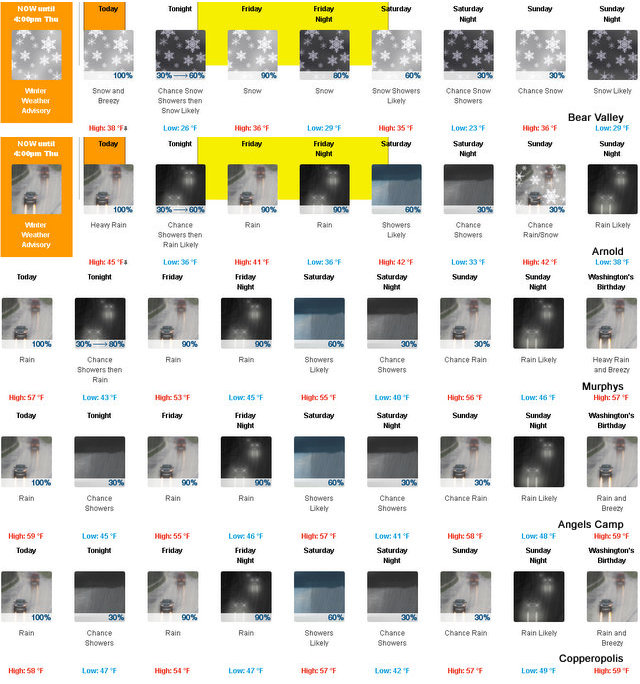
Tonight Mostly cloudy. A chance of rain showers at lower elevations…and a chance of rain and snow showers at higher elevations. Colder. Lows 22 to 37 higher elevations…35 to 41 lower elevations. No snow accumulation lower elevations…up to 1 inch higher elevations. Snow level 6000 feet. Prevailing southeast winds up to 15 mph.
Friday Rain at lower elevations…and rain and snow at higher elevations. Highs 29 to 43 higher elevations…41 to 49 lower elevations. No snow accumulation lower elevations…3 to 5 inches higher elevations. Snow level 6000 feet. Prevailing southeast winds up to 10 mph.
Friday Night Rain and snow in the evening, then rain and snow showers after midnight. Lows 24 to 38 higher elevations…36 to 42 lower elevations. No snow accumulation lower elevations…2 to 4 inches higher elevations. Snow level 6000 feet. Prevailing south winds up to 15 mph.
Saturday Rain and snow showers likely. Highs 29 to 43 higher elevations…42 to 50 lower elevations. No snow accumulation lower elevations…up to 3 inches higher elevations. Snow level 6000 feet. Prevailing southwest winds up to 10 mph.
Saturday Night Mostly cloudy with a chance of rain and snow showers. Colder. Lows 23 to 38.
Sunday Mostly cloudy with a chance of rain and snow. Highs 33 to 48.
Sunday Night Rain and snow likely. Moderate snow accumulations possible. Lows 28 to 43. .washingtons birthday and monday night…heavy rain and heavy snow. Very windy. Moderate snow accumulations possible. Highs 35 to 50. Lows 28 to 43.
Tuesday Through Wednesday Rain and snow showers. Windy. Moderate snow accumulations possible. Highs 30 to 45. Lows 26 to 41.
Winter Weather Advisory
URGENT – WINTER WEATHER MESSAGE
National Weather Service Sacramento CA
512 AM PST Thu Feb 16 2017
CAZ068-069-170115-
/O.CON.KSTO.WW.Y.0009.000000T0000Z-170217T0000Z/
/O.CON.KSTO.WS.A.0007.170217T1200Z-170218T1800Z/
Western Plumas County/Lassen Park-
West Slope Northern Sierra Nevada-
Including the cities of Chester, Quincy, and Blue Canyon
512 AM PST Thu Feb 16 2017
…WINTER WEATHER ADVISORY REMAINS IN EFFECT UNTIL 4 PM PST THIS
AFTERNOON…
…WINTER STORM WATCH REMAINS IN EFFECT FROM LATE TONIGHT THROUGH
SATURDAY MORNING…
The National Weather Service in Sacramento has issued a Winter
Weather Advisory, which is in effect through 4 PM PST Today.
A Winter Storm Watch is in effect from late Tonight through
Saturday morning.
* MAIN IMPACTS: Unprepared travelers may experience long delays.
Chain controls likely. Poor visibility may make travel
hazardous. Concern for mudslides over steeper terrain.
* CONFIDENCE…High.
* TIMING…Snow starting early this morning and continuing through
the afternoon. Another round of heavy snow Friday morning
through Saturday morning.
* LOCATIONS…Interstate 80 over Donner Pass, Highway 50 over
Echo Summit, Highway 88 over Carson Pass, and Lassen Park.
* SNOW ACCUMULATIONS…3 to 7 inches of snow possible above 6000
feet with up to a foot highest elevations today. Another 5 to 10
inches of snow Friday and Saturday with up to 18 inches higher
elevations.
* WIND…Southwest wind gusts between 25 and 35 mph. Ridgetop
gusts over 50 mph possible today
* OTHER IMPACTS…Snow combined with wind will create poor
visibility and hazardous travel
PRECAUTIONARY/PREPAREDNESS ACTIONS…
A Winter Weather Advisory means that periods of snow and gusty
winds will cause travel difficulties. Be prepared for slippery
roads and limited visibilities, and use caution while driving.
A Winter Storm Watch means there is a potential for significant
snow, that may impact travel. Continue to monitor the latest
forecasts.
&&
Interact with us via social media
www.facebook.com/nws.sacramento
www.twitter.com/nwssacramento
$$
Winter Storm Watch
URGENT – WINTER WEATHER MESSAGE
National Weather Service Sacramento CA
512 AM PST Thu Feb 16 2017
CAZ068-069-170115-
/O.CON.KSTO.WW.Y.0009.000000T0000Z-170217T0000Z/
/O.CON.KSTO.WS.A.0007.170217T1200Z-170218T1800Z/
Western Plumas County/Lassen Park-
West Slope Northern Sierra Nevada-
Including the cities of Chester, Quincy, and Blue Canyon
512 AM PST Thu Feb 16 2017
…WINTER WEATHER ADVISORY REMAINS IN EFFECT UNTIL 4 PM PST THIS
AFTERNOON…
…WINTER STORM WATCH REMAINS IN EFFECT FROM LATE TONIGHT THROUGH
SATURDAY MORNING…
The National Weather Service in Sacramento has issued a Winter
Weather Advisory, which is in effect through 4 PM PST Today.
A Winter Storm Watch is in effect from late Tonight through
Saturday morning.
* MAIN IMPACTS: Unprepared travelers may experience long delays.
Chain controls likely. Poor visibility may make travel
hazardous. Concern for mudslides over steeper terrain.
* CONFIDENCE…High.
* TIMING…Snow starting early this morning and continuing through
the afternoon. Another round of heavy snow Friday morning
through Saturday morning.
* LOCATIONS…Interstate 80 over Donner Pass, Highway 50 over
Echo Summit, Highway 88 over Carson Pass, and Lassen Park.
* SNOW ACCUMULATIONS…3 to 7 inches of snow possible above 6000
feet with up to a foot highest elevations today. Another 5 to 10
inches of snow Friday and Saturday with up to 18 inches higher
elevations.
* WIND…Southwest wind gusts between 25 and 35 mph. Ridgetop
gusts over 50 mph possible today
* OTHER IMPACTS…Snow combined with wind will create poor
visibility and hazardous travel
PRECAUTIONARY/PREPAREDNESS ACTIONS…
A Winter Weather Advisory means that periods of snow and gusty
winds will cause travel difficulties. Be prepared for slippery
roads and limited visibilities, and use caution while driving.
A Winter Storm Watch means there is a potential for significant
snow, that may impact travel. Continue to monitor the latest
forecasts.
&&
Interact with us via social media
www.facebook.com/nws.sacramento
www.twitter.com/nwssacramento
$$
A Wet Substance Is Falling From The Sky Again & Will For Next Few Days added by admin on
View all posts by admin →